
Pursuing a Fastest Known Time on the Tuckup Trail
Some adventures are more involved than others. The Tuckup happens to fall on the ‘more involved’ end of the spectrum; traversing the entire route tests not just your endurance and navigation skills but also your willingness to suffer.
Thankfully Ashly Winchester and I possess plenty of the latter, as well as some degree of the former.
What is the Tuckup, you may ask? It is a remote, rugged trail on the Esplanade level of the Grand Canyon — on the very remote and hard-to-access west end of the already quite remote and hard-to-access North Rim, to be specific. How long is it? Great question: nobody knows. The National Park Service tear sheet estimates that the trail is roughly 60 miles from east to west. It also cautions that “Mileages are very difficult/impossible to gage, because the terrain is so convoluted, and routes vary.” Copy that.
Ashly and I decided to set out on the Tuckup because of our shared love of long, hard routes and remote speed missions. As an added bonus the Grand Canyon is now my backyard and, thanks to my day job as co-owner of Dreamland Safari Tours, I am in a position to judge conditions & access to the Tuckup’s remote trailheads.
And so, on the first of November, we headed out towards 150 Mile Trailhead - the eastern terminus for the Tuckup. The few in-the-know folks that I had talked to about our plans all voiced the same opinion: that we were in for a beatdown, and an adventure where 20 miles feel like 100. Undeterred, Ashly and I readied our gear for what we figured would be a 60-80 mile route that shouldn’t take us much longer than 36 hours, at a conservative pace. After all, the trail is almost flat — how hard could it be?
Two of Dreamland’s finest, Andrea and Orion, volunteered to give us a ride to the eastern terminus. We were prepared for the fact that we might not be able to get to the trailhead on account of washed out roads after recent monsoon flooding. Turns out we were right, but not because of road conditions: our truck encountered worrisome transmission issues right at the National Park boundary, causing A&O to head back to Kanab while Ashly and I decided to use the remaining six road miles as a warm up. We started the approach hike to the trailhead at 3pm.

Truck down, time to start the human-powered part of our project.
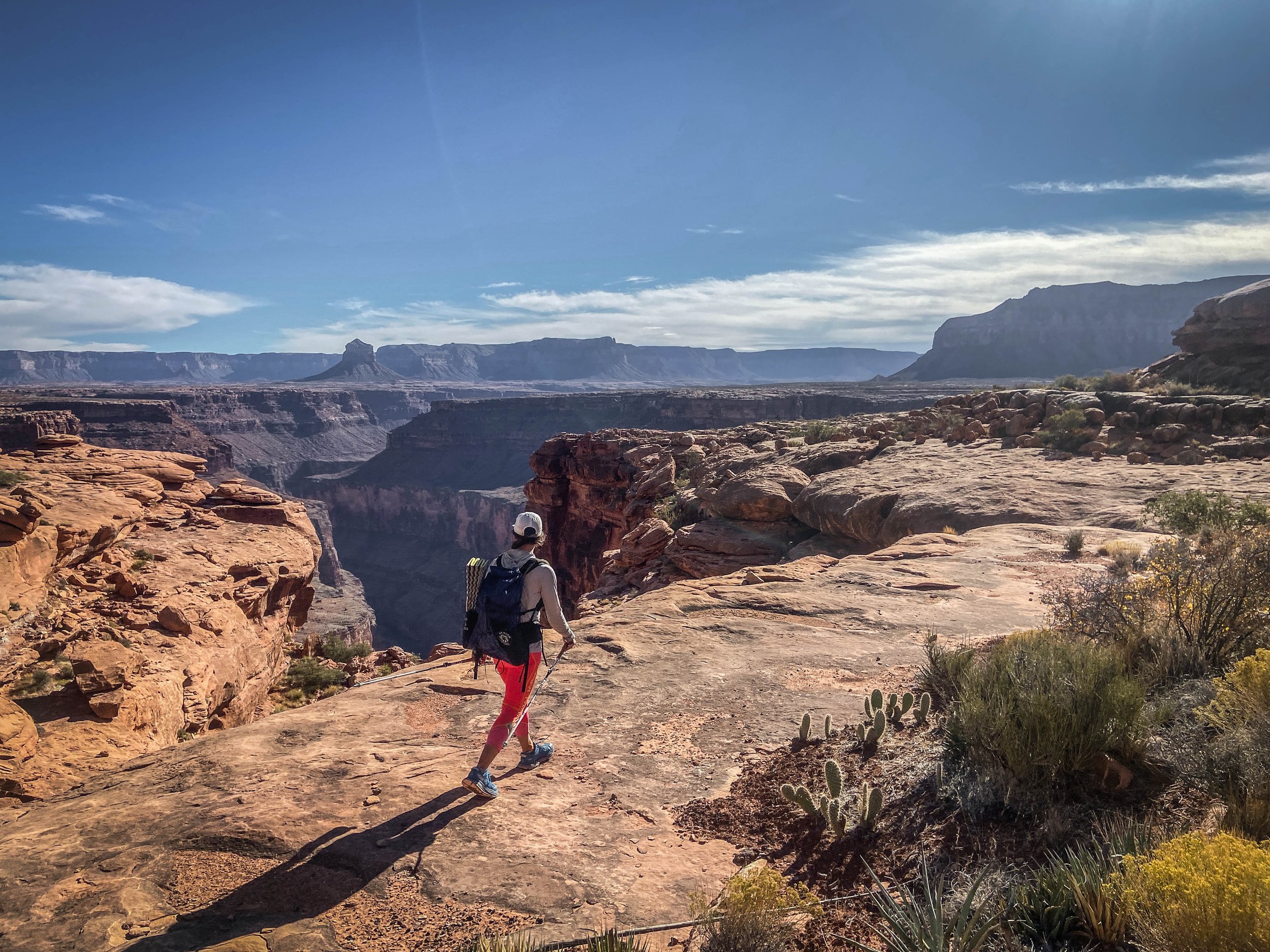
A little less than two hours later we had reached the trailhead (where four other vehicles were parked, so the road clearly was passable) and were ready to get going for real. We took a bit of a break to refresh our feet and legs, and started our watches for the Tuckup Fastest Known Time attempt at 5:15pm. The trail led us down an abrupt, steep descent into the canyon and soon we found ourselves in the land of canyon time and canyon miles, where normal chronology does not apply.
We quickly find out that even a conservative 2 miles-an-hour pace is stiff here on the east side of the Tuckup, and night-time navigation is near impossible - even with a bomber GPS track. There is barely any trail; cactus, century plants and other pricklies abound. The Esplanade itself may be largely flat, but there is a maze of side canyons and arroyos to navigate. To borrow another adventurer’s apt description: traversing the Esplanade feels like being trapped in a fractal.
“Traversing the Esplanade feels like being trapped in a fractal”
Our initial plan had been to push through the night, put down as many miles as possible, and set ourselves up for a 36 hour finish — 48 hours tops, if things were to be slow. Yet a few hours after dark we have barely covered ten miles, and the terrain is getting harder not easier. I spend a lot of time in the lead, and continuously have to rely on my headlamp’s high beam to try and make sense of the maze of canyon end runs and precipitous drops that we are facing. While I love my Nite Ize headlamps, I know fully well that I haven’t brought enough battery power to sustain high beam use for what is now going to be a minimum of two full nights. At the same time both Ashly and I quickly realize that onsighting a fast time on this “trail” is going to be impossible, so we decide to change tack.

Sunset was pretty; navigating in the dark was not.
Drawing lessons from my multi-day experience on the Iditarod Trail, I suggest that we sleep early and plentifully - a minimum of three+ hours vs the 30-60 minutes that so often characterize hard FKT pushes. We bed down over an hour before midnight; I set my alarm for 2am. Tired and reluctant to leave our respective sleeping bags, we end up snoozing and watching shooting stars from the warmth of our sleep setups until after 4am.
Day 2 is our make or break: Ashly and I know that we need to find water today, or else bail at the halfway point of the route. Water on the Tuckup is available only from a few springs of mixed water quality or productivity, and — a much better option — potholes that will hold water after rain. It had rained just about week prior to the start of our attempt, so we are hopeful; but while we have seen traces of pothole water the first evening we also encounter a lot of dried up sources. The water that we did see early on was so shallow and close to evaporation that the only way to harvest it would have been with a sponge. We know we are coming up hard against the end of this particular rain water window: for every one pothole that does hold water, we probably walk past 1000+ empty ones.
To Ashly’s and my great relief we do find water not just in Cork Spring (which is barely running and very bitter tasting), but also in the occasional pothole along the way. By the time we reach our halfway point and sole possible bailout option just below Schmutz Trailhead, it is clear: while water isn’t abundant, it’ll be enough to get us through. We’re moving atrociously slow, but don’t have to bail for fear of dehydration.

Ashly contemplating one of our lucky potholes. Over the course of 80+ miles we found ~six distinct spots where there was a tiny bit of pothole water to be had.
So we keep on keeping on. Our hopes of faster daytime progress dissipate as the hours tick by. We barely cover 25 miles, despite moving from 4:30am until after dark. It is hard to say what exactly makes this trail so hard, but hard it is. Finding and collecting water takes up precious time. Climbing from the Esplanade level into the Hermit Formation and sometimes seemingly as high as the Coconino Sandstone in order to end-run side canyons takes up precious time. Finding shaded spots to escape the sun and cool down our core temperatures takes up precious time. Dancing two-step with a thousand cacti takes up precious time. Everything takes time; the hours fly by, yet the miles are barely passing.
Night two, day three: more of the same. Ashly and I have a serious talk about bailing at the halfway point, but with water in the picture we decide that we just don’t have a reason to not complete the route. It may take us twice as long as we expected, but we do have what we need to get it done.
It’s hard, it’s slow, and yet there is a consistent theme for our journey above and beyond aches and difficulty: joy, and laughter. We both find humor in the most absurd of situations. We start calling the Tuckup “Trail” the Magic Trail - first, because it does feel like magic when we find our first actual trail segments; later, because the trail proves time and again that it knows how to put on a disappearing act that would put serious magicians to shame. Thanks, Tuckup.

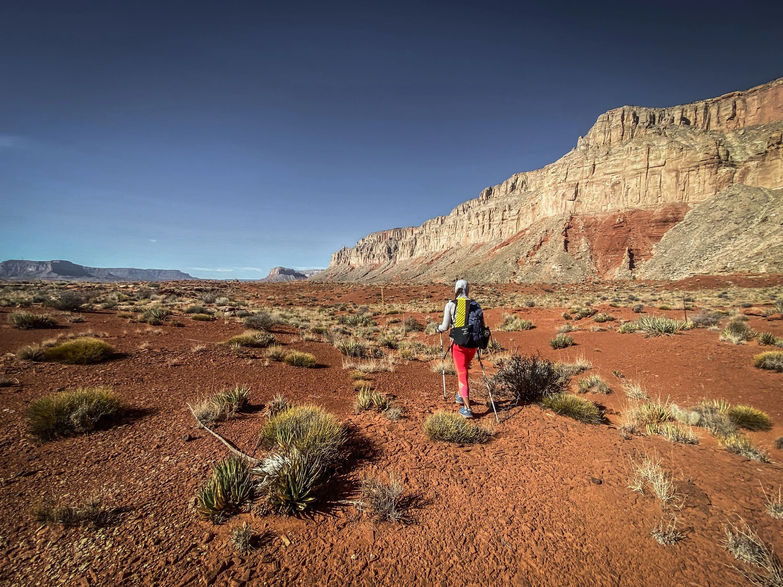
Magic Trail: don’t be deceived by this picture. Most of the Tuckup looks nothing like this.
By the time Day 3 rolls around I am starting to harbor serious concerns about missing the bus. The bus, in this case, is Maddi & Robert — another two of Dreamland’s extraordinary guides who have agreed to take a personal camping trip to Toroweap (one of Dreamland’s off-road tour destinations) in order to be there when we finish, and give us a ride back to Kanab. The catch is this: Toroweap closes its gates for the night half an hour after sunset, which at this time of year is around 7:30pm. I am keenly aware that, should we finish our adventure too late in the day on Thursday, none of us will make it home for work on Friday.
Ashly and I push hard, moving until long after dark and getting back up long before daybreak in order to get through the miles that separate us from Toroweap. The kicker is this: as the crow flies, Toroweap is only ~4-5 miles from our final bivy spot. Factor in the fractal hell of end-running end runs, and we still have a good 15-20 miles to cover to get from where we sleep our final sleep back to the Western trailhead.
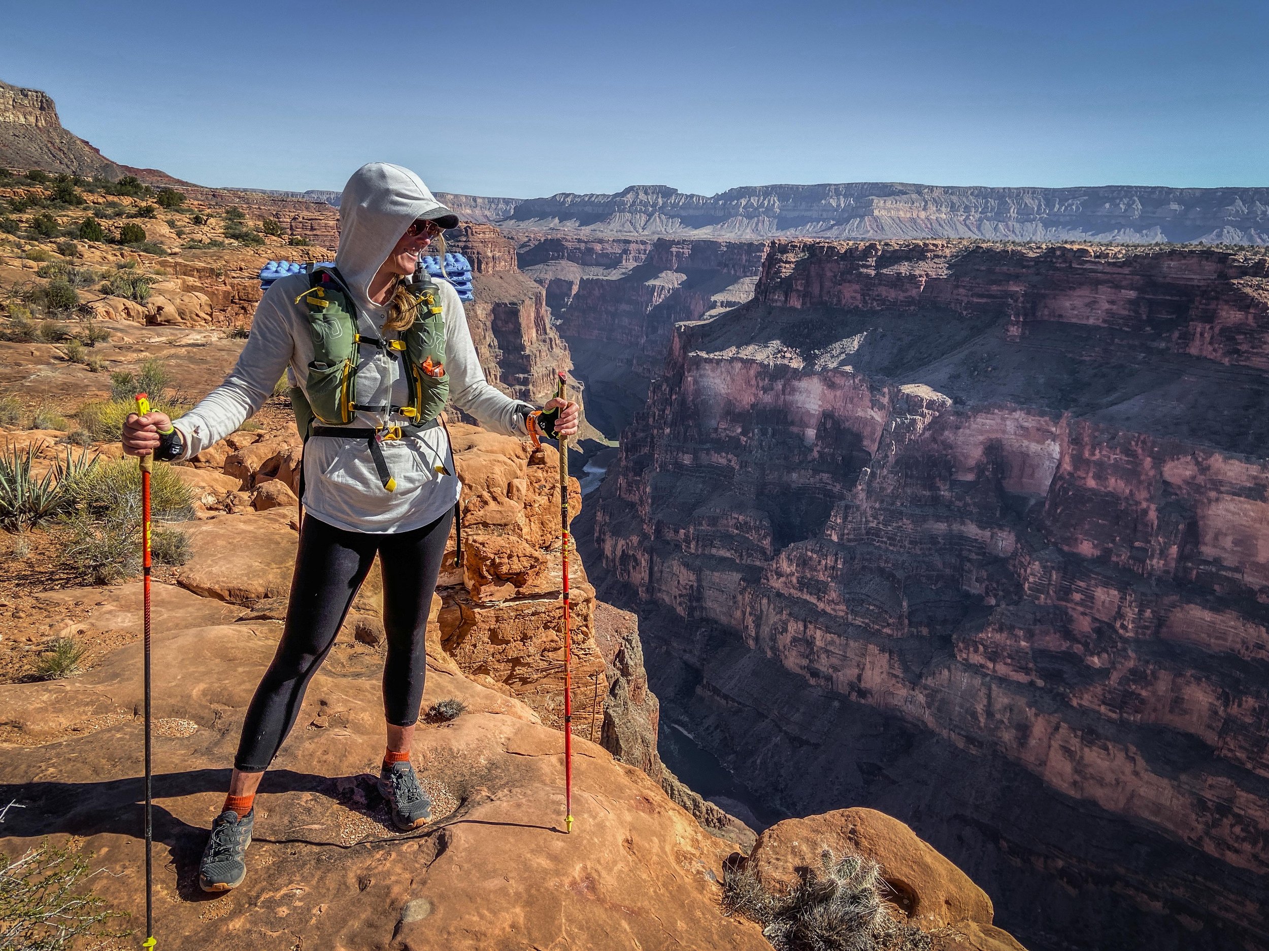
After 75+ miles, we’re finally back on my home turf — the final three miles to Toroweap come with amazing views like this one: 3,000ft straight down to the Colorado River.
And then, on Day 4 (speaking of calendar days… looking at elapsed time, we’re still sub 70 hours), we finally do find easy footing and the semblance of real trail. As the National Park tear sheet accurately states: “The trail [from Toroweap] begins deceptively easily.” We make good time and we finally get to enjoy the views that Toroweap is famous for: a sheer 3,000ft drop straight down to the Colorado River. Rather than missing the bus, Ashly and I beat our revised-and-revised-again finish time estimate by over half an hour, finishing all 80 brutal miles of the Tuckup Trail in 69 hours and 21 minutes.

Made it!
It’s hard to put in words what this adventure meant to me and Ashly, but I will say this: the Esplanade of the Grand Canyon feels more remote and inescapable than anything else I have experienced in the lower 48 to date. The Tuckup is a formidable adventure, and it depends on endurance, skill, and good conditions. To anyone who may plan to repeat this route as a fast-push effort I will say this: make good choices, and be ready for the consequences. It is possible, but it requires planning as well as flexibility.
Tactical considerations: gear, water, and more
What would we do differently if we were to do it again? How could you do this route faster? Here are a few things that come to mind immediately:
The temperatures were still too hot. Later in the fall/winter would bring cooler days, though it also comes with potentially more difficult road access and even shorter days. An early spring trip would likely be prime: longer days, still cool temps, and possibly full potholes from winter moisture.
Start time, aka respect the trail. We started down from 150 Mile Trailhead at 5:15pm, thinking all we needed was to get down to the Esplanade and have a bit of daylight to get used to Esplanade level navigation. Far from it — east-side navigation is tough and near impossible in the dark. If I were to do this again, I’d plan to sleep at the trail head and then head out about an hour before first light. Day #1 should be as much daytime navigation as possible to get through some of the roughest sections.
Water capacity. Ashly and I each carried 4-4.5 liters of water, and we essentially kept our capacity filled to the brim at all times. The only time we needed the entire capacity was for the stretch from Big Point to Toroweap, though we found a bit of pothole water even in there. Now… pothole water isn’t to be counted on, and wouldn’t have been there had we been any farther removed from the last rain. That said, I’d venture to say that it IS possible to do the Tuckup on spring water only if you’re willing to drink mineral-rich water — I’d want to have 6 liters of carrying capacity though to be on the safe side.
Gear. Our gear generally worked out great, though next time I would forgo running tights in favor of long hiking pants and also consider adding running gaiters. I’d add tweezers to my first-aid kit (cactus!), and plan for plenty of battery power or solar charging ability to support headlamp high beam use for any and all night-time travel. Beyond that, here’s what Ashly and I each brought:
Fastpack — mine was the trusty Ultimate Direction Fastpack 40 that I also used on the Grand Canyon R2R2R-alt
Running poles — absolutely indispensable for this terrain; Ashly and I both used LEKI poles, mine are the ridiculously lightweight Micro Trail model
3 quarter length foam pad
Ultra lightweight sleeping bag — a 20 degree Sierra Designs quilt for me, and a 40 degree bag coupled with a SOL emergency bivy for Ashly
Headlamp(s)
4 liters of water capacity
Water filter + iodine tabs for backup (yes my water filter did clog!)
8000 calories: in my case: lots of GU chews, stroop wafels, gels and Roctane drink mix, as well as a bit of beef jerky
Comfortable, lightweight yet sturdy trail shoes — my model of choice are the LOWA Maddox Lo
GPS communicator — for the obvious reasons: safety, crew communication, and FKT verification.
GPS track. We had a GPS track that I pawned from Gaia, and it was great 85% of the time. The other 15% seemed like it led us to no-mans-land that hadn’t seen a visitor in years (thinking particularly about end-runs near Toroweap, where I suspect we followed an obscure, out-of-use route that was way higher up than necessary). It’d be ideal to obtain a GPS track from someone with recent, solid experience on the Tuckup.
Stats
To sum it all up, Ashly and I spent 69 hours and 21 minutes on the route (plus 6 miles / 2hrs of approach hike before the real start). According to Ashly’s GPS watch, we covered ~81 miles and roughly 13,000ft of ascent. Our packs weighed about 22lbs at the beginning of our adventure, and we each came home with only a few hundred calories to spare. We saw precisely 0 people in between the two trailheads, though we did follow footsteps for a while that couldn’t have been older than a day or two.
The Tuckup is an amazing route, and I will highly recommend it for any intrepid adventurer who prizes self-sufficiency and is OK with slow, hard terrain. I know I’ll come back - just not for another FKT. My next go around on the Tuckup is going to be SLOW with all the time in the world for side trips and explorations.