White Pocket, Arizona: What Nobody Tells You About Getting There (and Why That's the Point)

Comment

White Pocket, Arizona: What Nobody Tells You About Getting There (and Why That's the Point)

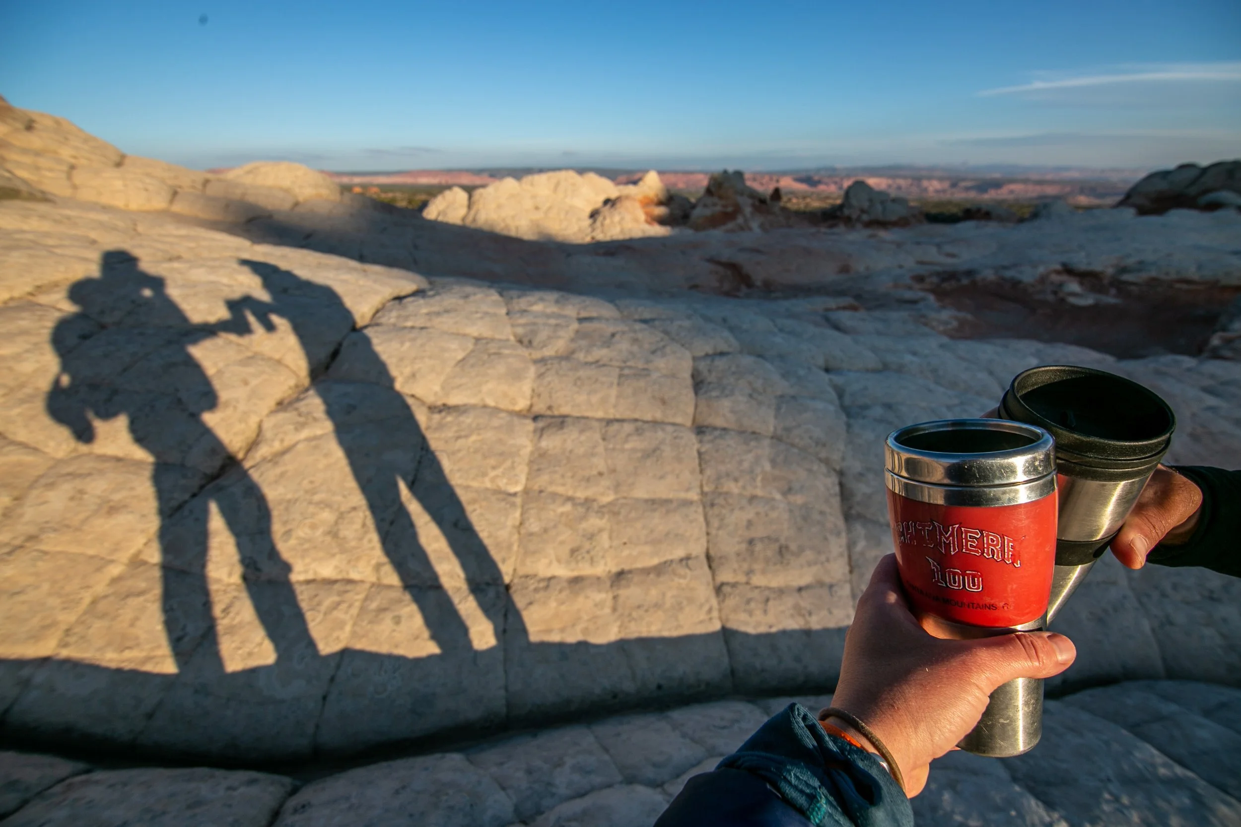
Most of what I’m talking about on this blog is big adventures that have some (but minor) overlap with the businesses that Paul and I run. Today, I want to switch that up a little bit, because I’ve gotten so many questions about White Pocket over the years and it feels like it’s high time for me to share my thoughts on why that spot, in this remote corner of the Vermilion Cliffs, stole my heart and sealed the deal when Paul and I first considered taking over Dreamland Safari Tours in early 2020.

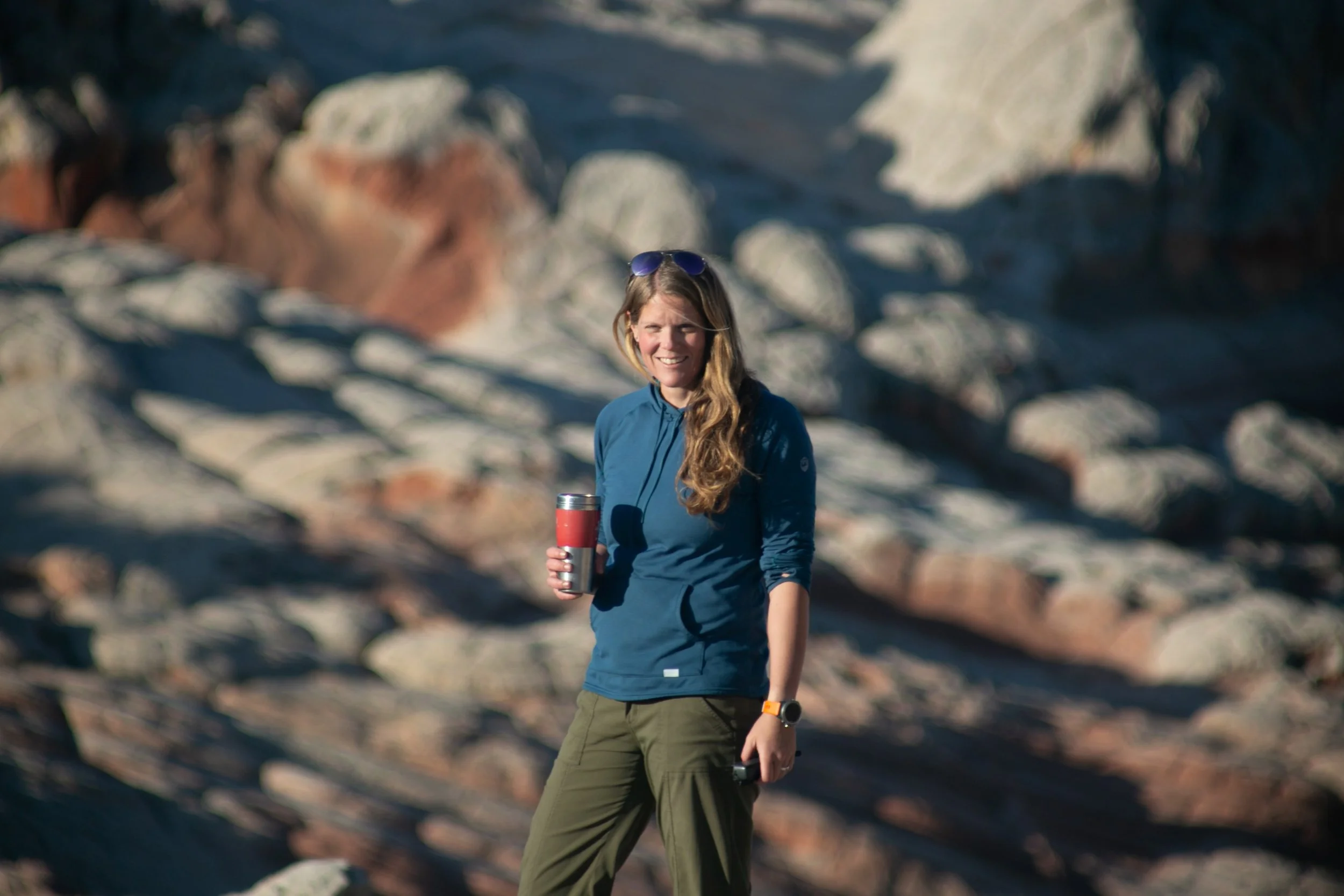
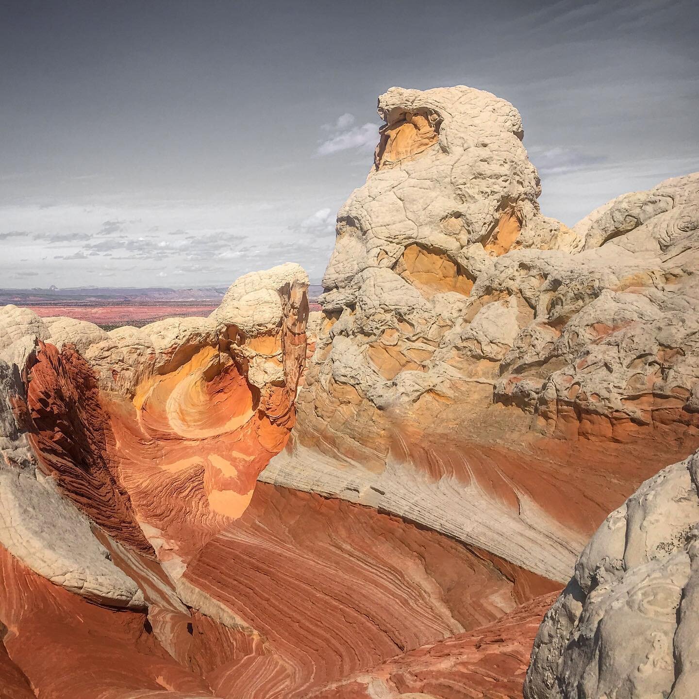
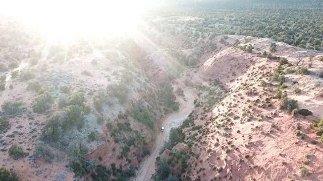
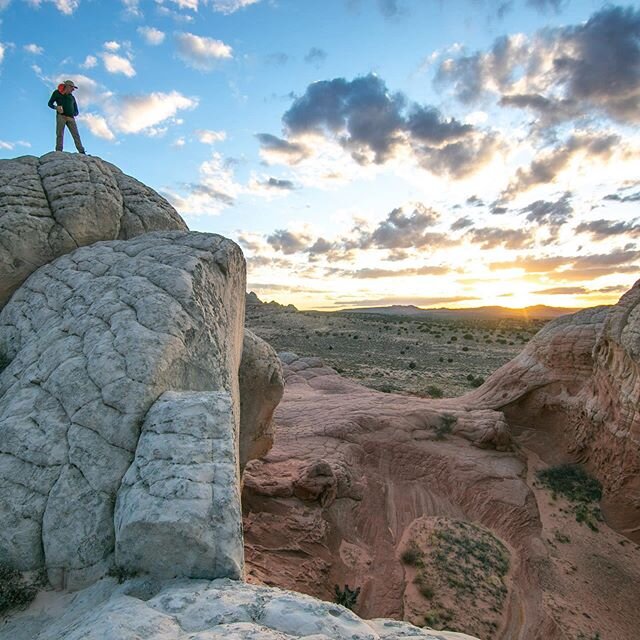
During an early visit to White Pocket (2020)

By now, I've been to White Pocket more than 30 times since Paul and I took over Dreamland six years ago. Some of our senior guides have been out there 300+ times - over a decade of leading trips across the same deep-sand roads to the same 20 acres of rock. You'd think that kind of repetition would dull the place but really… it doesn't. That's the strange thing about White Pocket: it operates on a different logic than most landscapes. Our guides still come back with photos of formations they swear they've never seen before, and after 30-something personal visits I believe them, because it keeps happening to me too. I still pull out my camera or iPhone to take photos everytime I’m out there myself!

So: what makes White Pocket so spectacular, and do you need a guide to visit White Pocket? The answer is: I’ll try to tell you but really - you need to see it for yourself to understand - and, no, you don't need a guide (IF…. you hit a lot of buckets like having a proper 4WD high-clearance vehicle, know how to air down your tires, etc etc).

I'll tell you exactly how to get there yourself, what to watch out for, and when to go. And then I'll tell you why I think most people should seriously consider not doing it alone - which is a conflicted thing to say, given that I run a tour company and have an obvious financial interest in your decision. I'll try to be honest about both sides. You can decide.

So what is it about White Pocket?

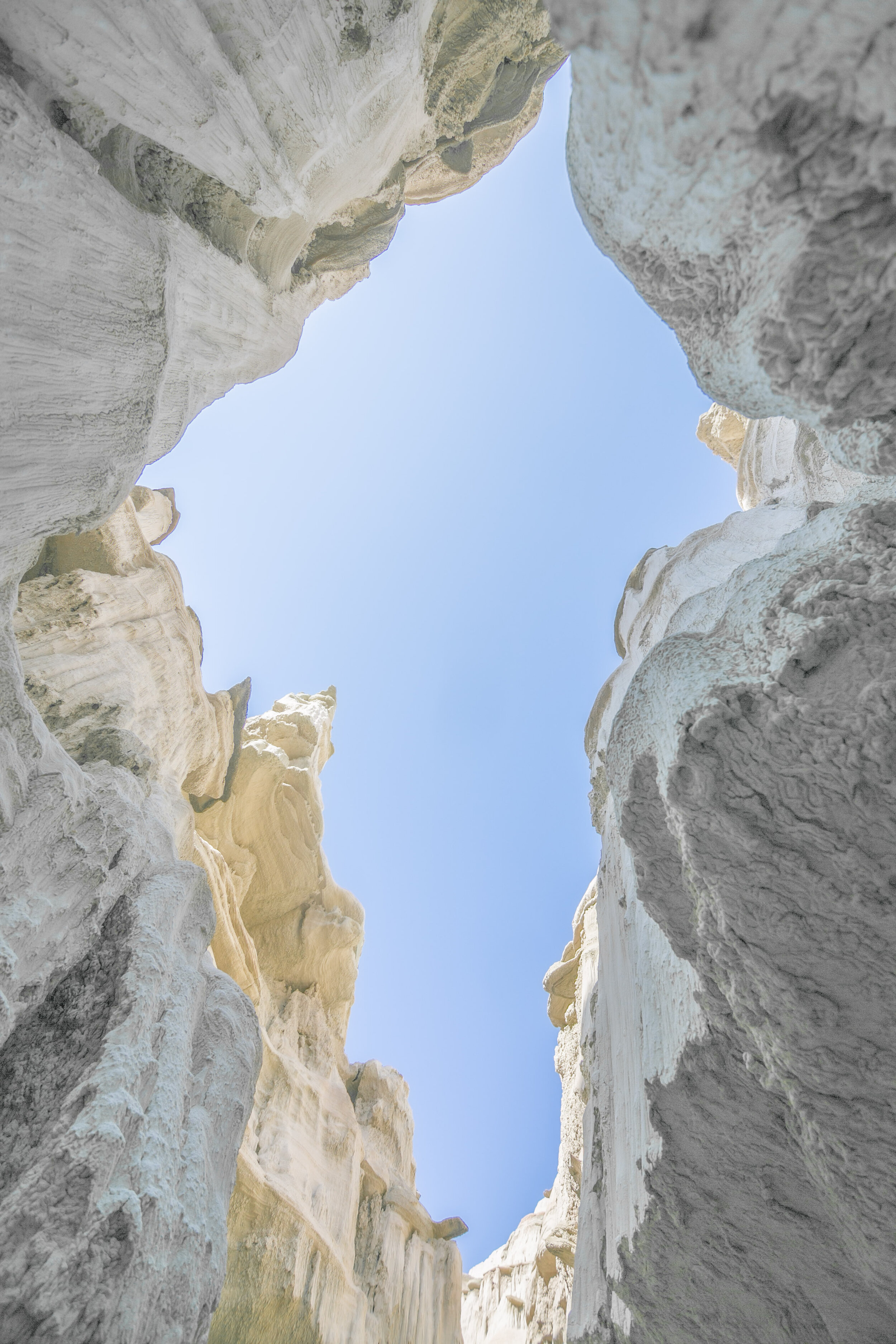
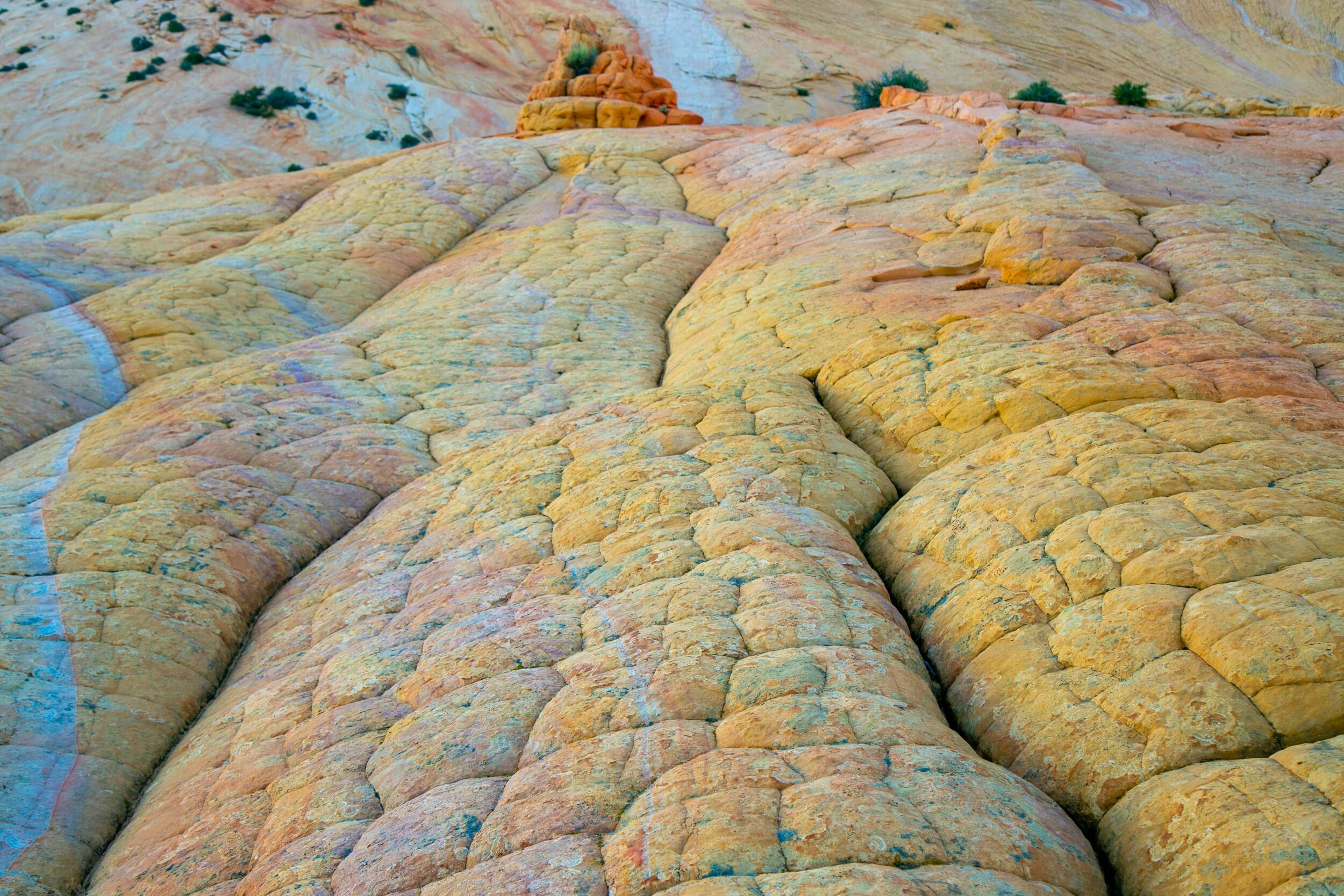
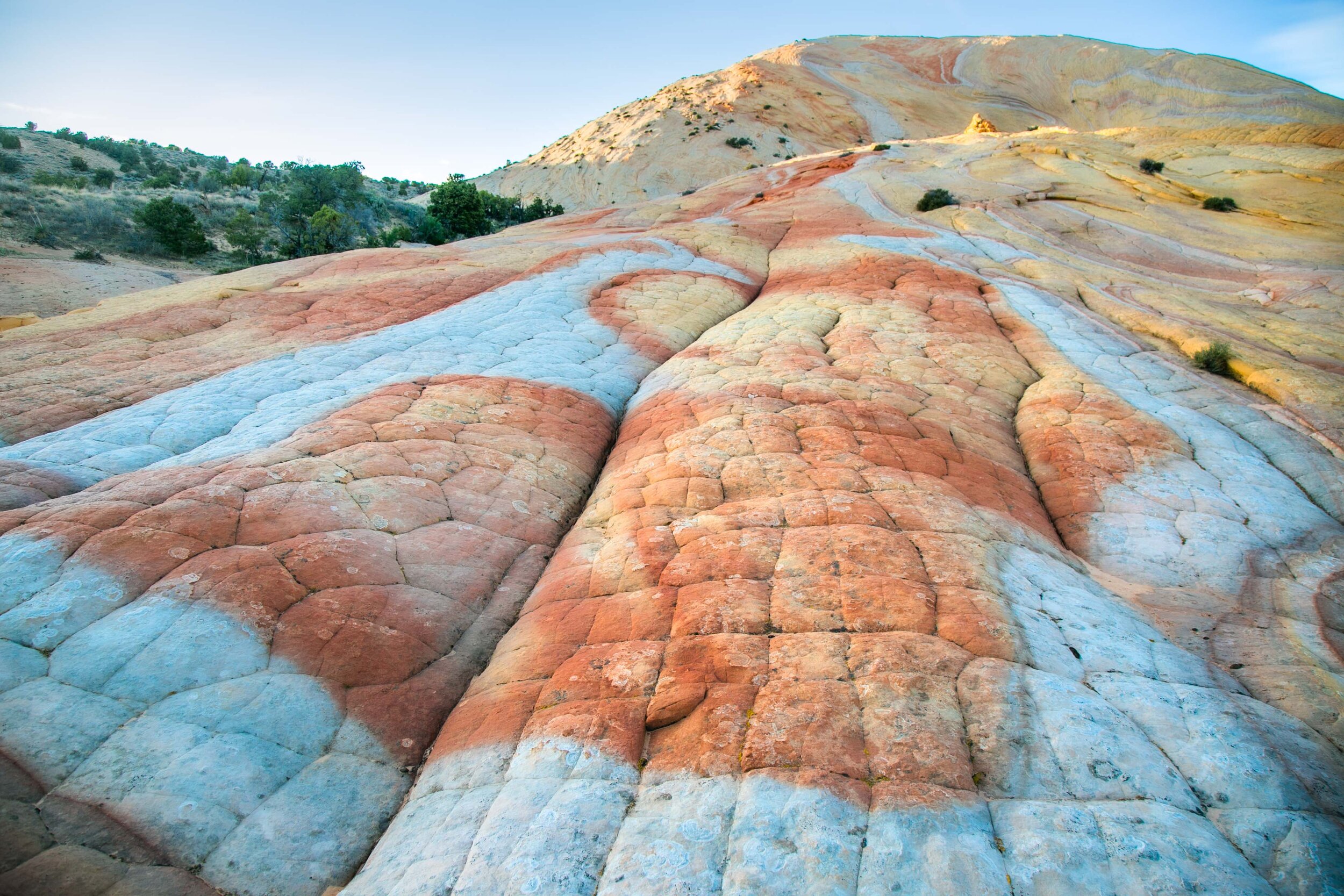
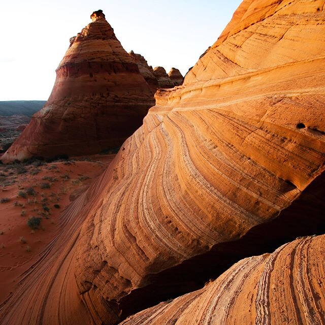
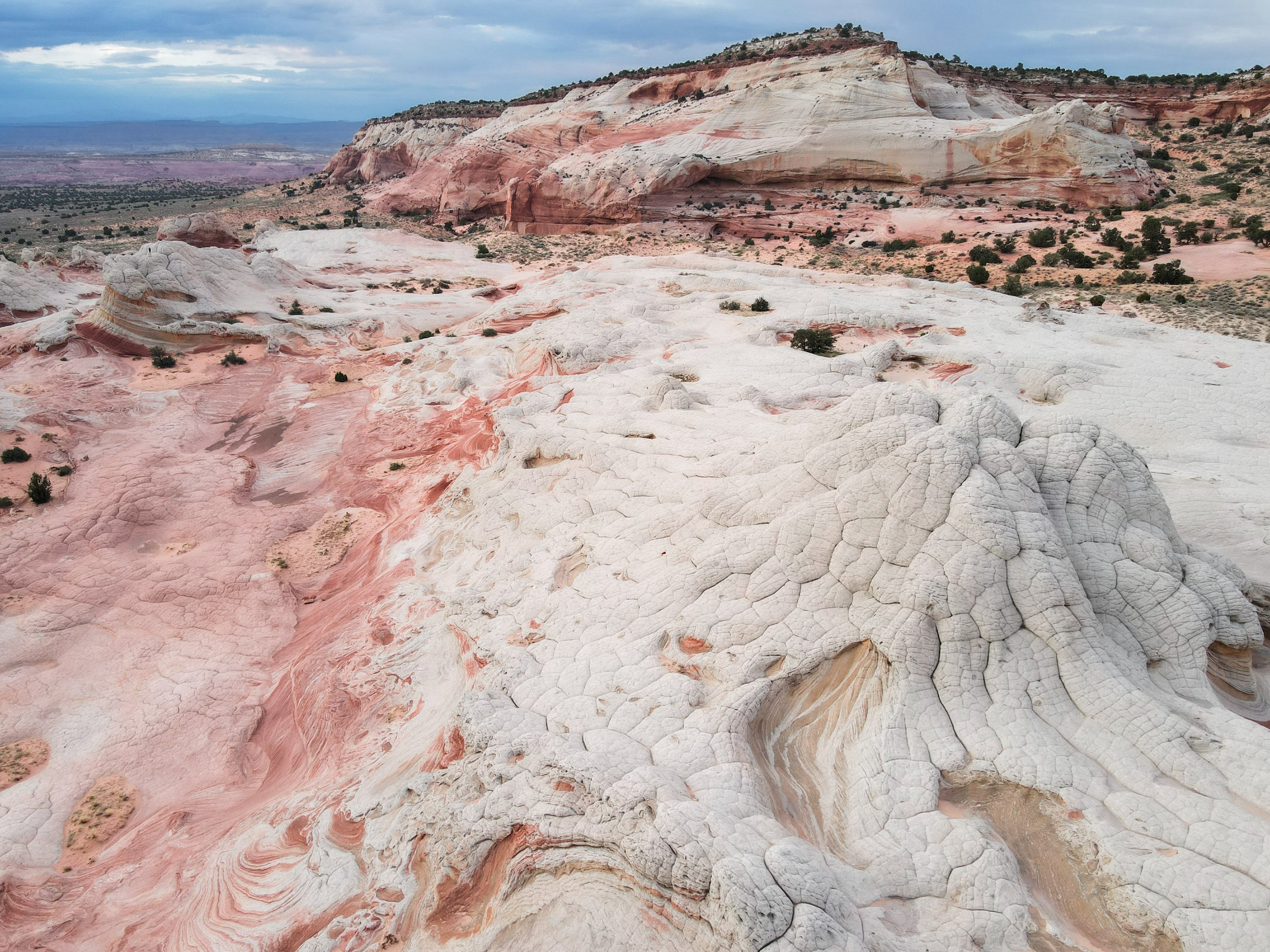
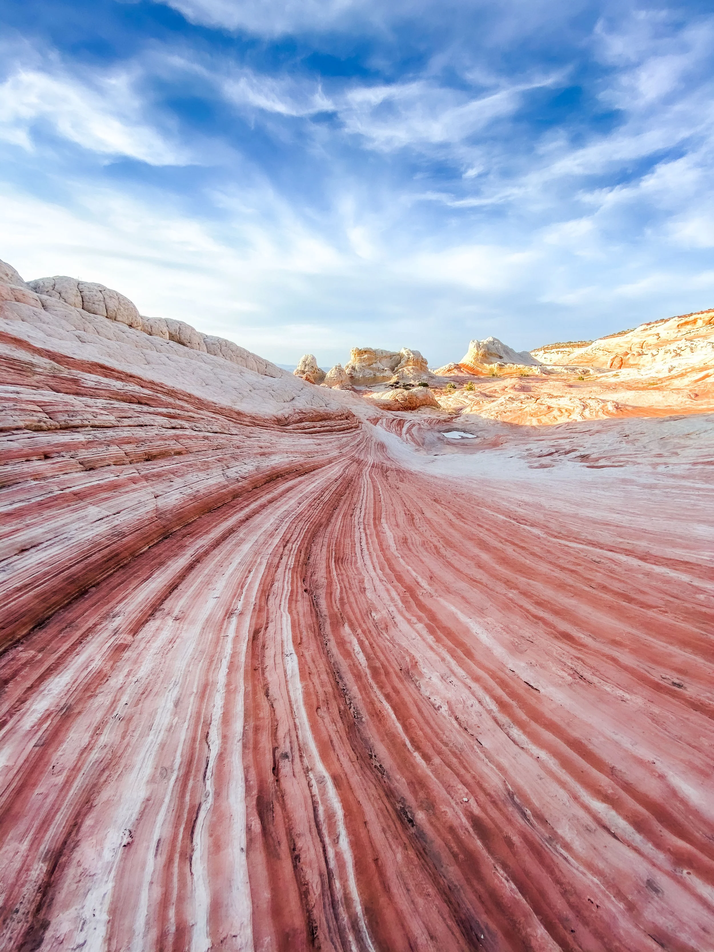
The short version: imagine 20 acres of Navajo Sandstone that looks like it was designed by a fever dream. White polygonal plates - "brain rock" - cracked and tilted at improbable angles. Deep red iron oxide streaks bleeding through white stone like watercolor on wet paper. Swirls that curve into themselves and then just... stop, for no apparent reason. Solution cavities the size of bathtubs carved into rock that's 190 million years old. The whole formation sits on a remote plateau in the Vermilion Cliffs, ringed by the Grand Staircase and the red walls of the Coyote Buttes, and there is no trail. You just walk out onto the rock and start looking. Every time I go, I find something I haven't seen before - a new pocket of color, a micro-arch I walked right past last time, a pattern in the cross-bedding that only shows up when the light hits at a certain angle. It is, genuinely one of the most visually dense landscape I've encountered anywhere - and I've spent a lot of time in a lot of strange places.

The drive is the filter

White Pocket sits on the Paria Plateau in the Vermilion Cliffs National Monument, technically in Arizona but less than three miles from the Utah border. The closest town is Kanab, Utah - our home - and from Kanab the drive takes about two and a half hours each way. Most of that time is spent on dirt roads, and the last stretch is deep sand. Not packed sand, not hard-pan. Loose, rutted, axle-grabbing sand that swallows rental SUVs and spits out tow bills north of a thousand dollars.

This is not an exaggeration. Every year the BLM posts warnings about it. Every year people ignore them. I've personally pulled strangers out of sand pits with our Suburbans more times than I can count, and I've watched recovery trucks make the long haul out to rescue people who got in over their heads. The ones who rented a Jeep Wrangler with aggressive tires usually do fine. The ones who showed up in an AWD crossover because "AWD is basically the same thing, right?" - those are the ones sitting on the side of the road at 3pm wondering how their day went sideways.

Here's the honest assessment: if you have a true 4WD vehicle with decent clearance, if you know how to air down your tires, and if you're comfortable driving in sand, you can absolutely get to White Pocket on your own. No permit required, no fee, no reservation. Just show up and explore. The BLM office in Kanab and the Kanab Visitor Center both have detailed maps and current road condition reports (stop in before you go) and we have a great primer about deep sand driving and the road to White Pocket on the Dreamland website here. A GPS is non-negotiable; cell service is nonexistent out there, and the unsigned intersections all look the same.

If you don't have the right vehicle or the sand-driving experience, hire a guide. I'd say that even if I didn't own a guide company. Getting stuck 90 minutes from pavement with no cell service and no shade is not the kind of adventure story that's fun to tell later.

What you're actually looking at

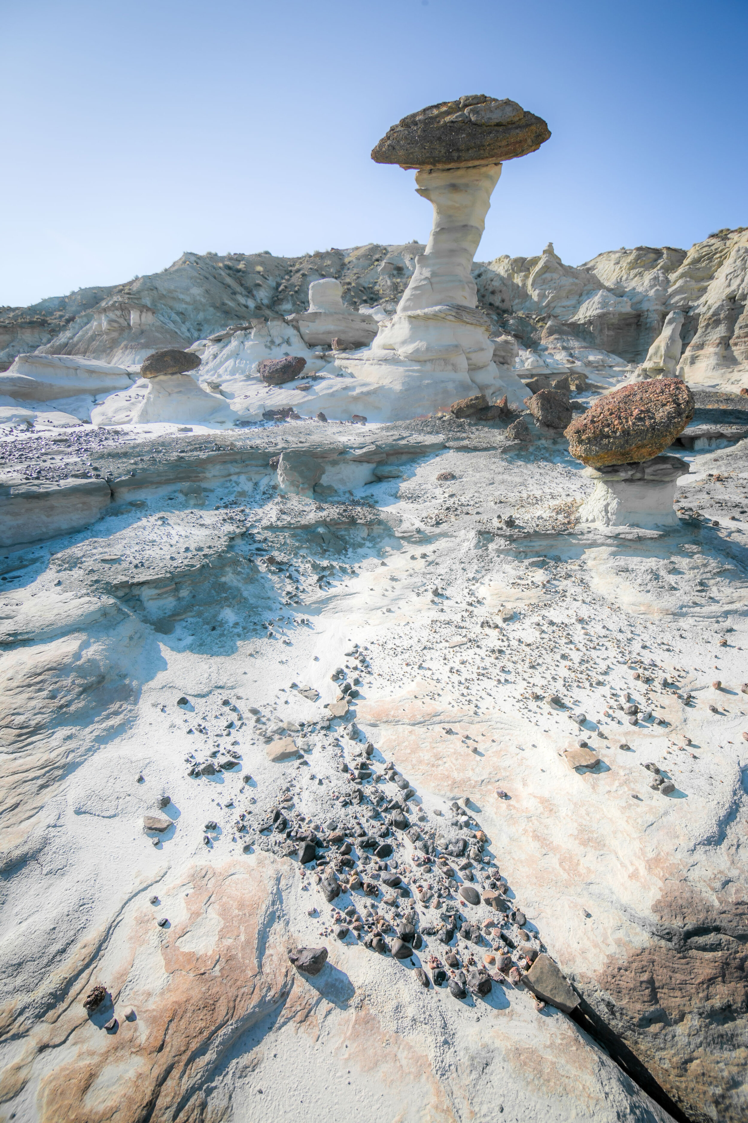
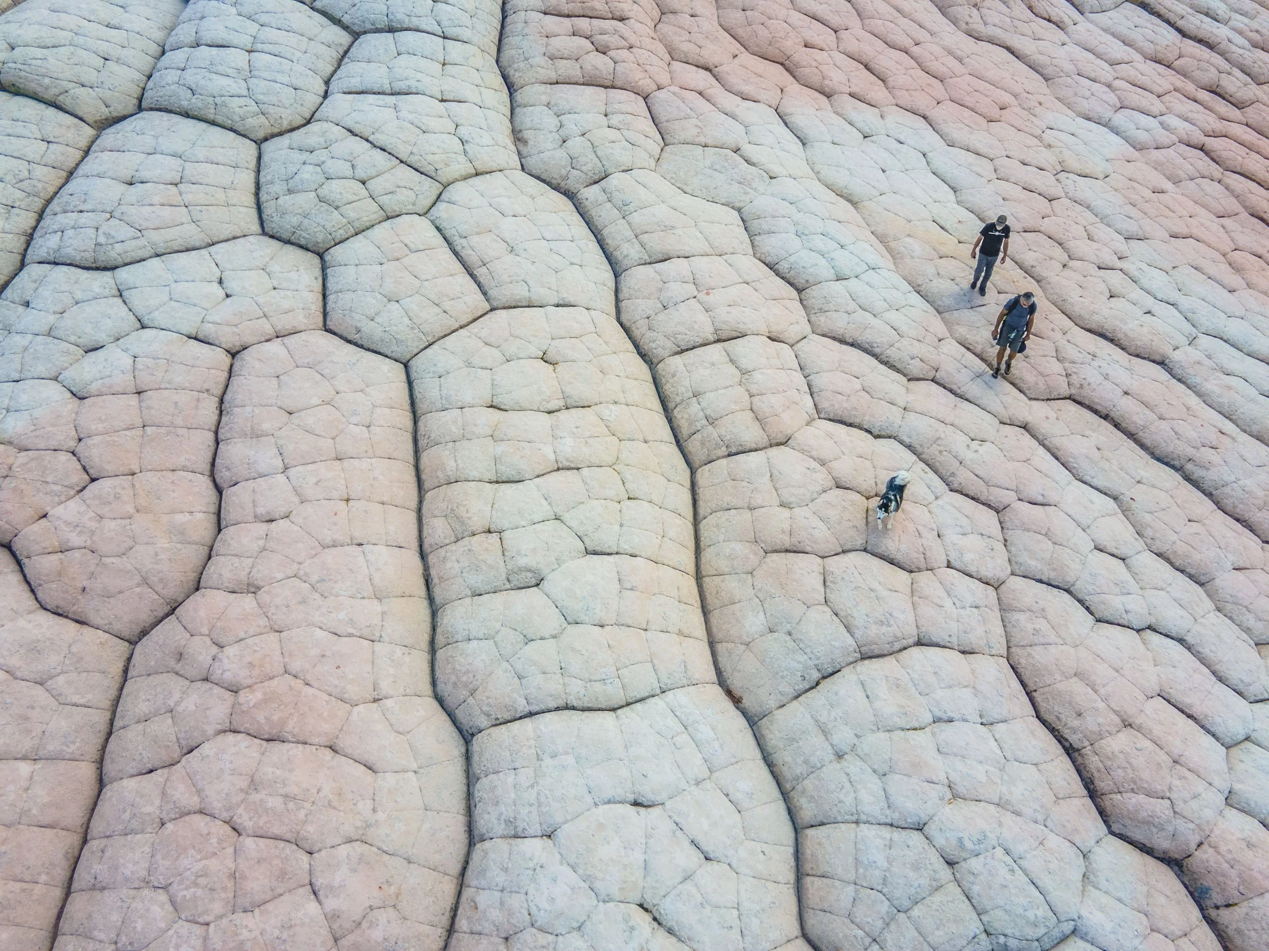
Most blog posts about White Pocket describe it as "brain rock" or "like another planet" and leave it there. Fair enough - the formations do look like a cross between a coral reef and a CT scan. But the geology is more interesting than the metaphors.

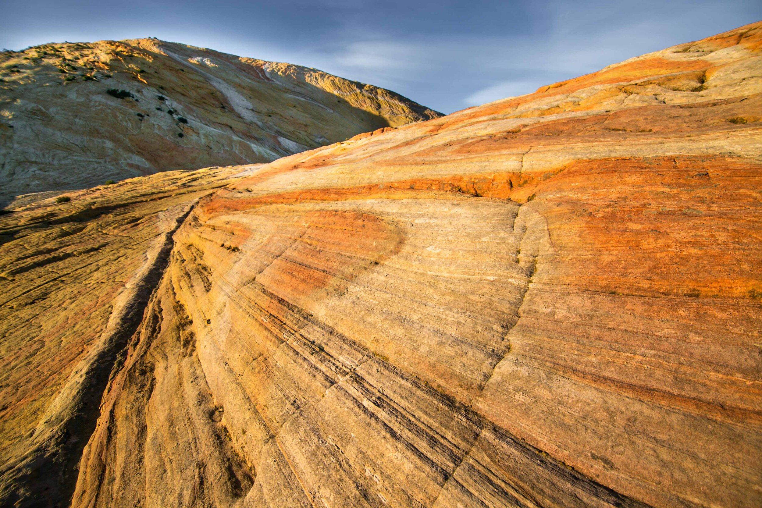
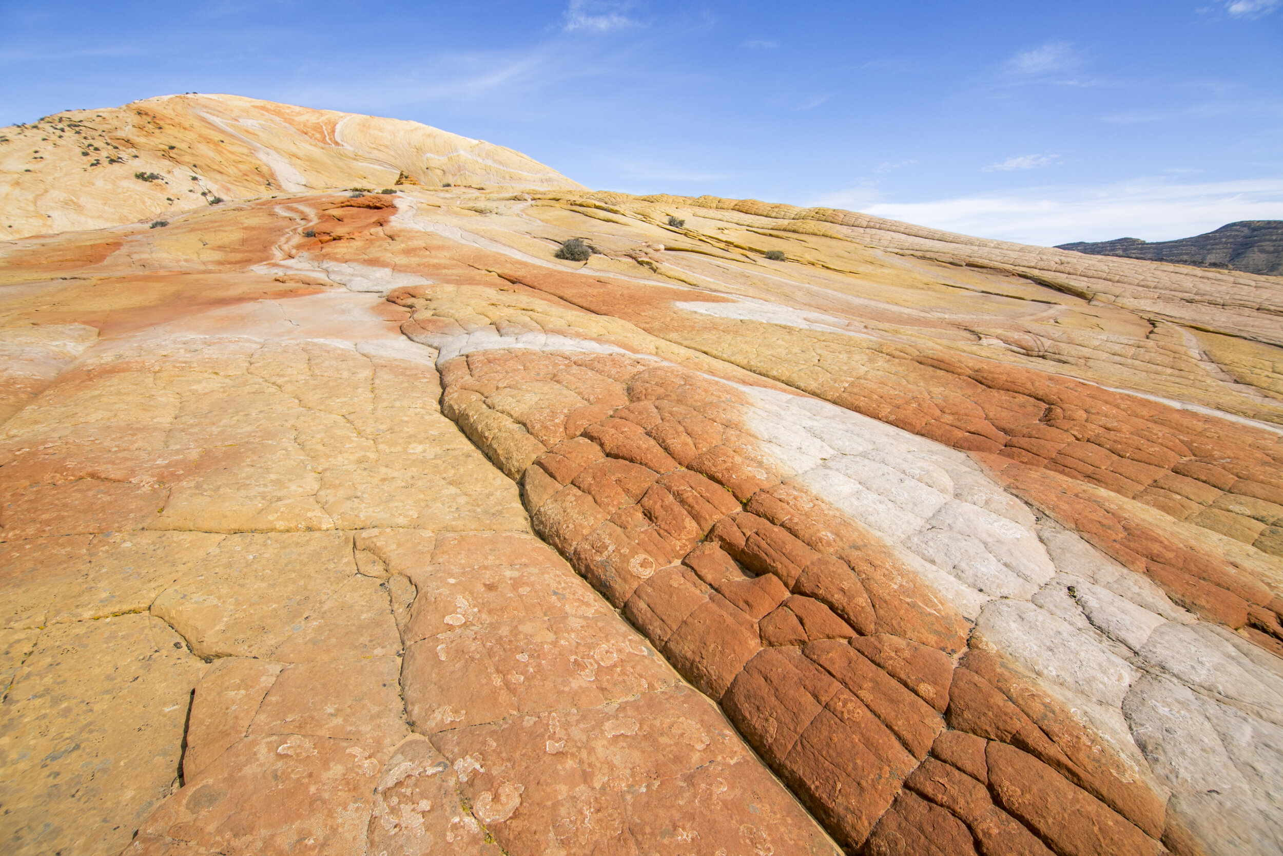
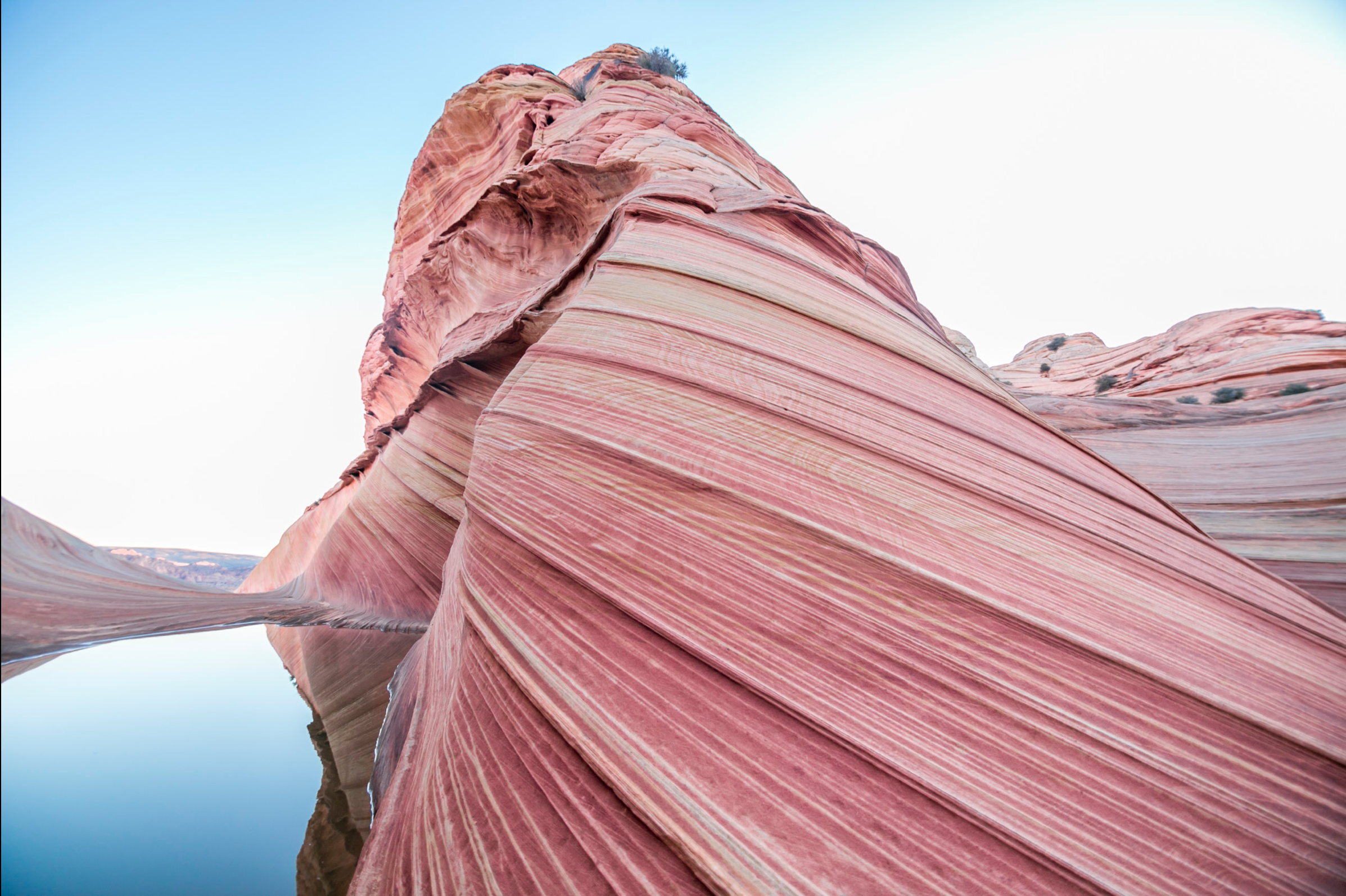
White Pocket is Navajo Sandstone, roughly 190 million years old - the same formation that makes up the Wave at Coyote Buttes North, just 6.5 miles away as the raven flies. Same rock, same age, wildly different outcome. The Wave is smooth, symmetrical, photogenically layered. White Pocket is chaotic; polygonal plates of white rock fractured and tilted at odd angles, streaked through with iron oxide reds and oranges, pockmarked with solution cavities, swirled into patterns that genuinely don't look like they should exist in nature.

Here's the thing that most visitors don't realize and that I find endlessly interesting: geologists still don't agree on how White Pocket formed. The leading theory involves differential weathering and iron oxide cementation, but the mechanism that produced the polygonal "brain" pattern specifically is still debated. I've listened to geologists argue about it on our tours. I've read the papers. Nobody has a clean answer. For a person who spent her pre-outdoor career in strategy consulting, where every problem was supposed to yield to structured analysis, I find a landscape that resists explanation deeply satisfying. White Pocket doesn't owe us a theory.

The case for going alone

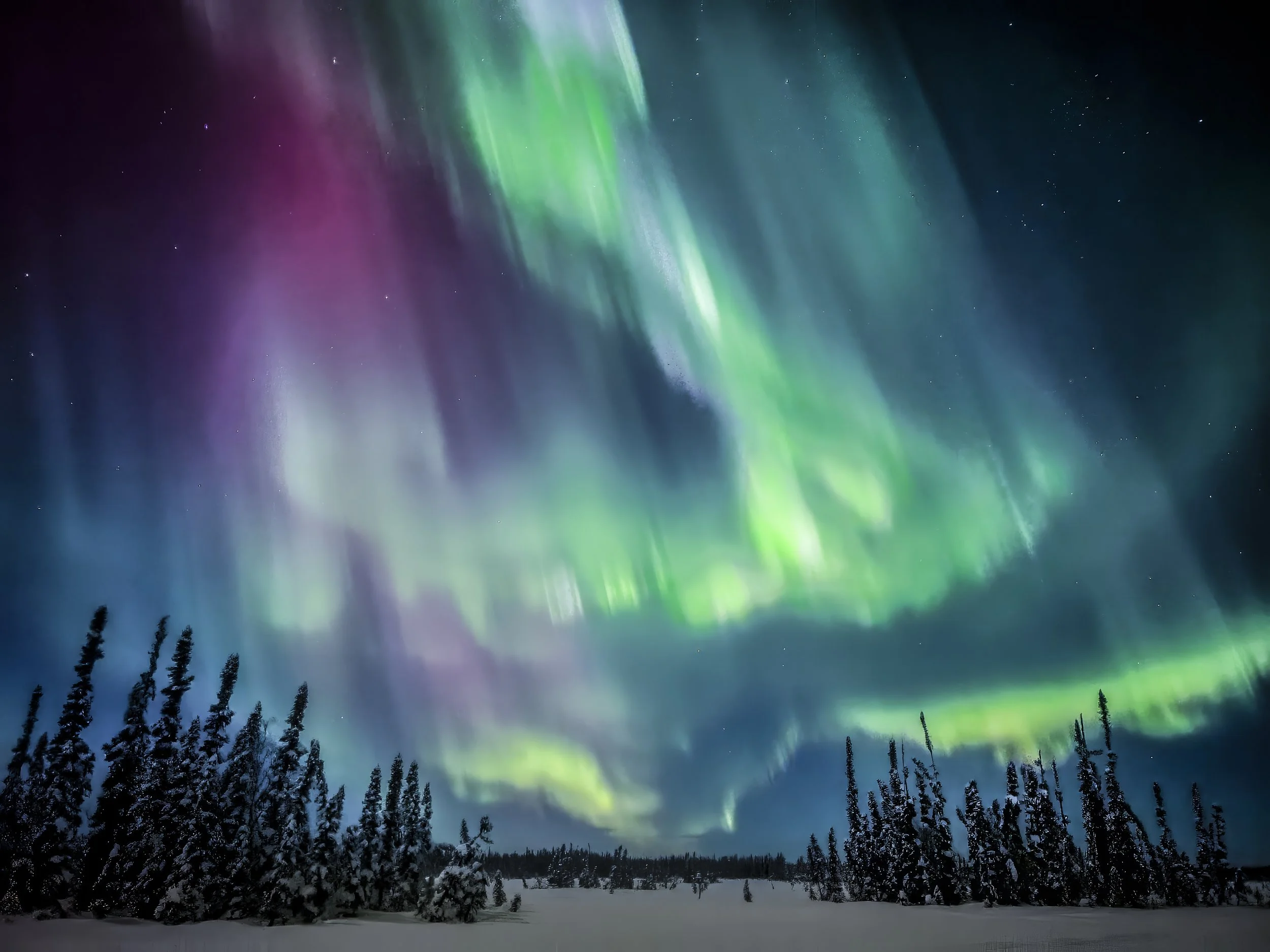
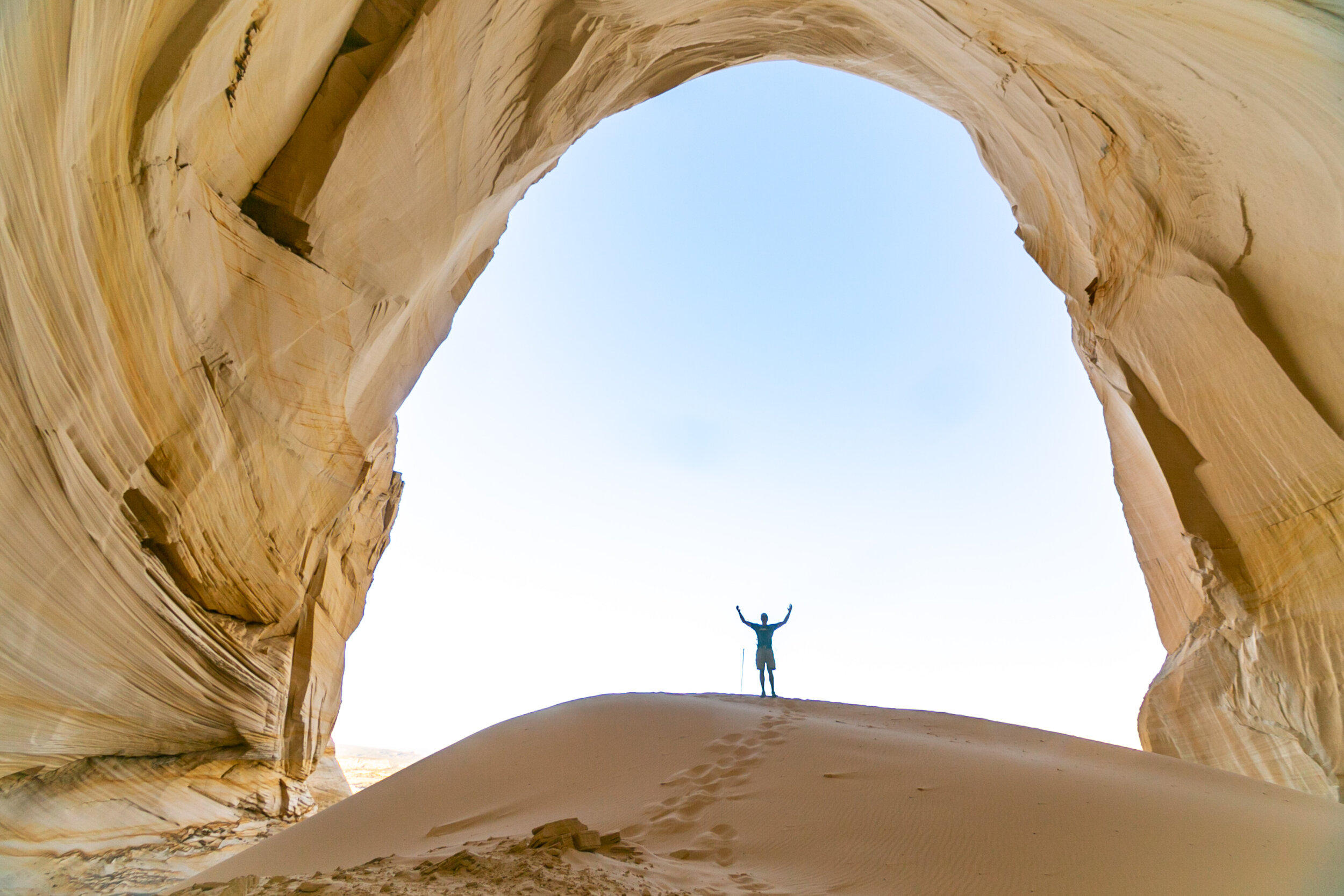
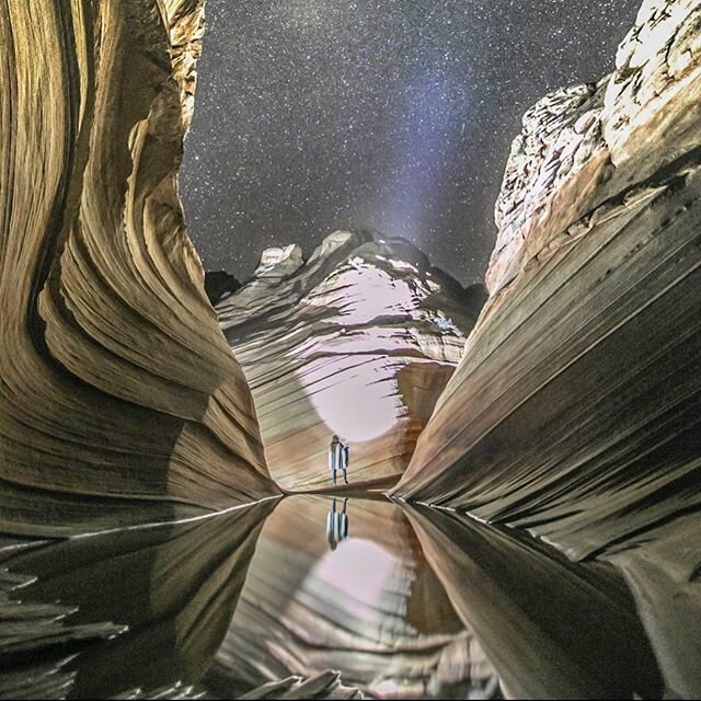
You save money. You set your own schedule. You can camp overnight for free (existing campsites only; pack out everything including human waste) and shoot the Milky Way without coordinating with anyone. The dark skies out there are extraordinary - Bortle Class 2, essentially zero light pollution, the kind of darkness where the galaxy throws shadows. If you're an experienced photographer with your own 4WD rig, a solo overnight at White Pocket might be the single best astrophotography opportunity in the American Southwest.

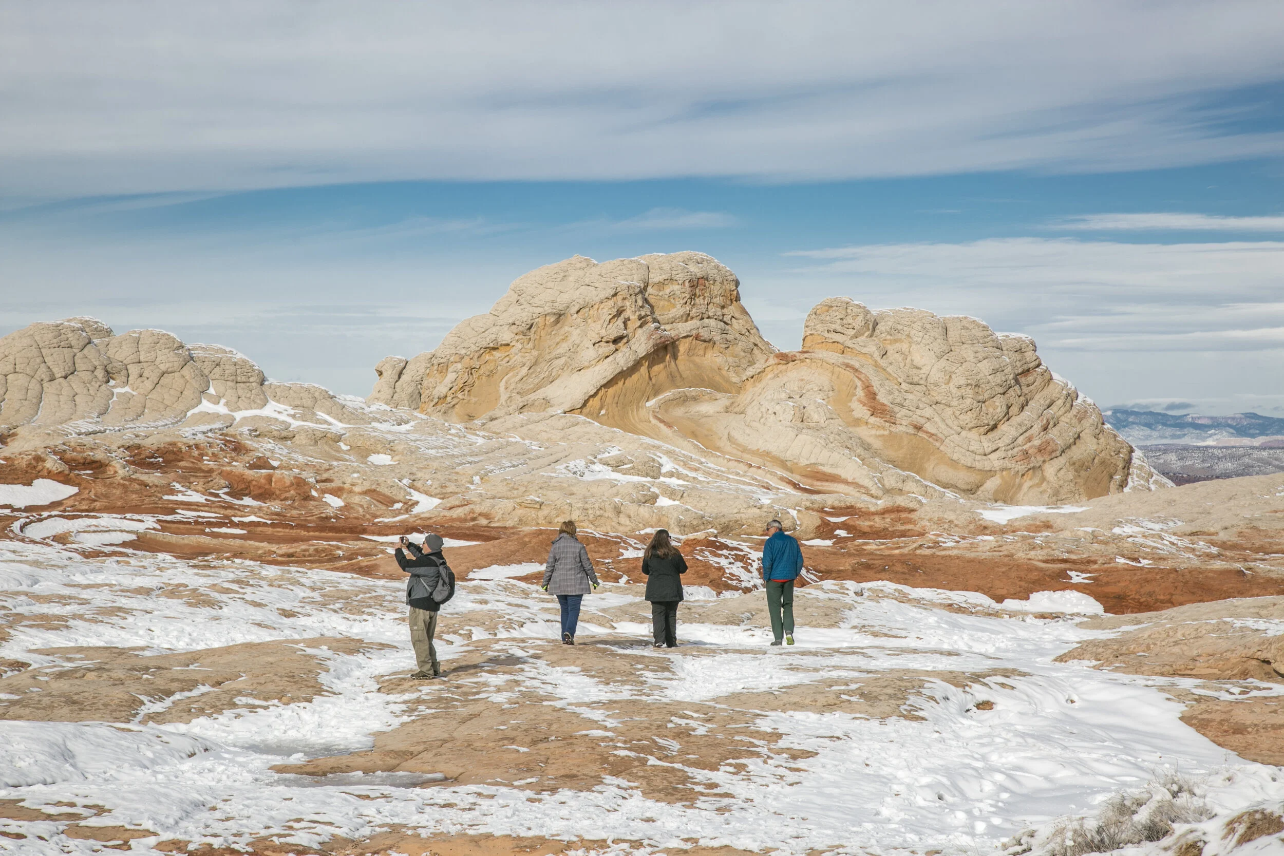
There's also something to be said for solitude. On a midweek visit in the off-season, you might have the entire 20-acre formation to yourself. No trail, no designated route, no markers. You walk out onto the rock and go wherever curiosity takes you. That kind of unstructured exploration is increasingly rare in the public lands of the Southwest, where even "off the beaten path" destinations are starting to feel managed. White Pocket, for now, still feels genuinely free.

The case for NOT going alone

I'll be transparent: you already know that Paul and I run Dreamland Safari Tours; what you wouldn’t know without me telling you is that White Pocket is one of our most popular trips. So take what follows with appropriate skepticism. But here's what I've observed over years of running these trips:

Most people underexplore it. Without a guide, the average visitor parks, walks onto the first visible formation, takes photos for 45 minutes to an hour, and leaves. They've seen maybe 10% of what's there. Our guides know where the hidden alcoves are, where the best "brain rock" concentrations sit, where the iron oxide striations are most vivid, where to stand at different times of day for the best light. This isn't gatekeeping - it's just pattern recognition built over years. White Pocket is deceptively large and its best features aren't always the most obvious ones.

The drive is stressful if you're not used to it. Sand driving requires a specific skill set and a specific mindset. If you're white-knuckling the steering wheel for 90 minutes in each direction, you arrive at White Pocket already tired and anxious. I've seen this more times than I can count - on my own trips and in stories our guides bring back daily. The people who drove themselves are often checking the time by noon, worrying about the drive back, calculating how much daylight they have left. The people who rode with us are relaxed. They spent the drive looking out the window at the Vermilion Cliffs. They have all day. It's a different experience, and not in a subtle way.

The geology is better with context. This one's subjective, but I believe it. The formations at White Pocket are stunning on their own, but they become genuinely fascinating when someone can explain the iron oxide story, point out the Liesegang bands, show you where the cross-bedding shifts direction and what that implies about 190-million-year-old wind patterns. Our guides are naturalists, not script-readers. They geek out about this stuff because they actually care about it.

When to go

Spring (March through May) and fall (September through November) are the best windows. Summer brings monsoon storms that turn the access roads to impassable mud - and temperatures above 100°F on exposed slickrock with no shade. Winter can work if you don't mind cold; the formations photograph beautifully with low-angle winter light and you'll have the place almost entirely to yourself.

For photography: golden hour (sunrise and sunset) and the two hours surrounding them produce the best light on the formations. Midday sun washes out the subtle color variations in the rock. If you're doing an overnight - whether self-supported or on one of our overnight camping trips - you get both bookend light sessions plus the night sky. It's the reason we started running overnights in the first place; Paul and I camped out there to celebrate our wedding anniversary years ago and realized that a single day visit, however good, only tells half the story.

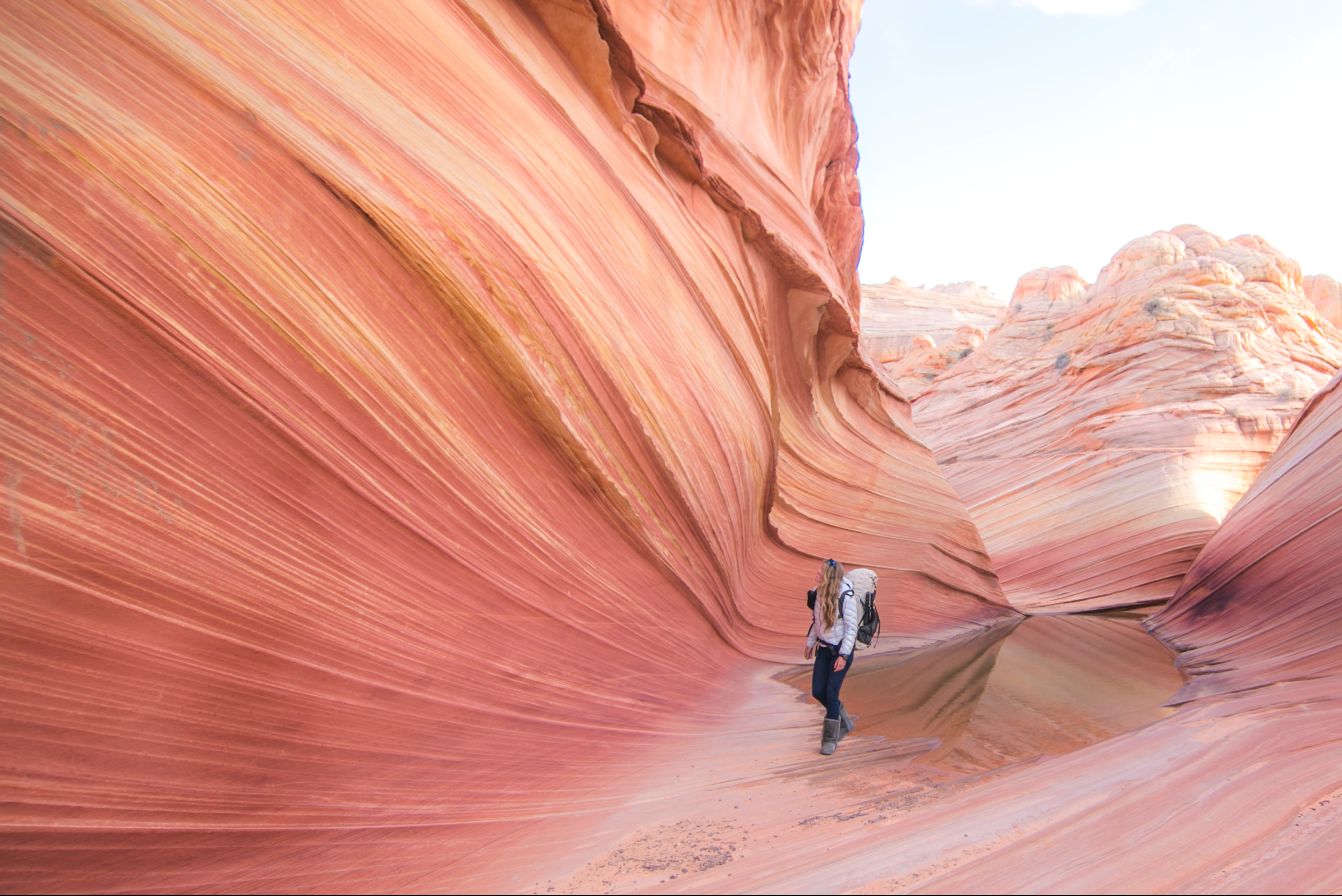
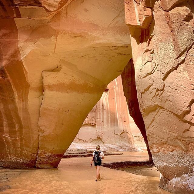
The honest comparison: White Pocket vs. the Wave

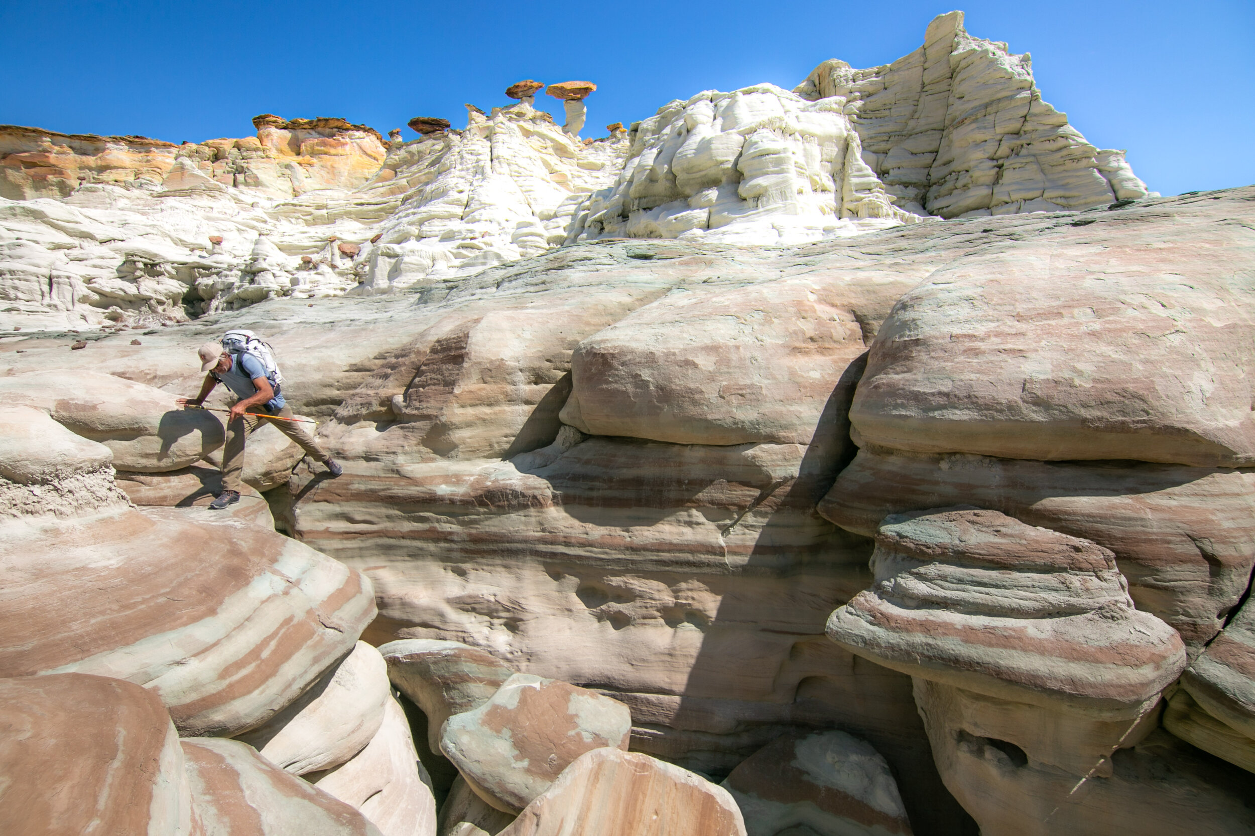
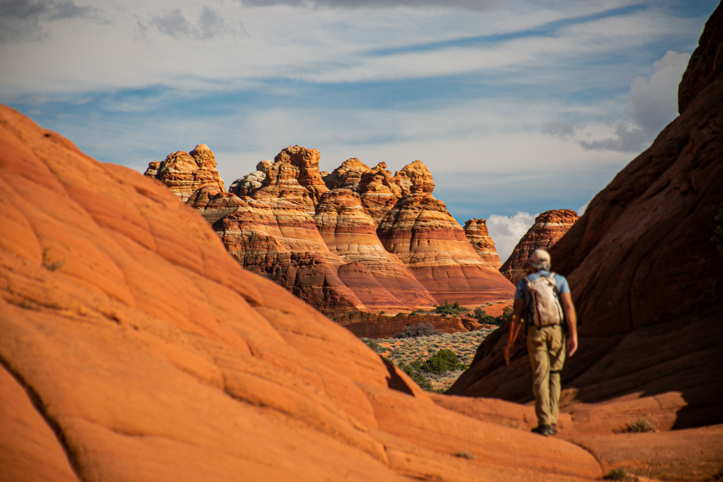
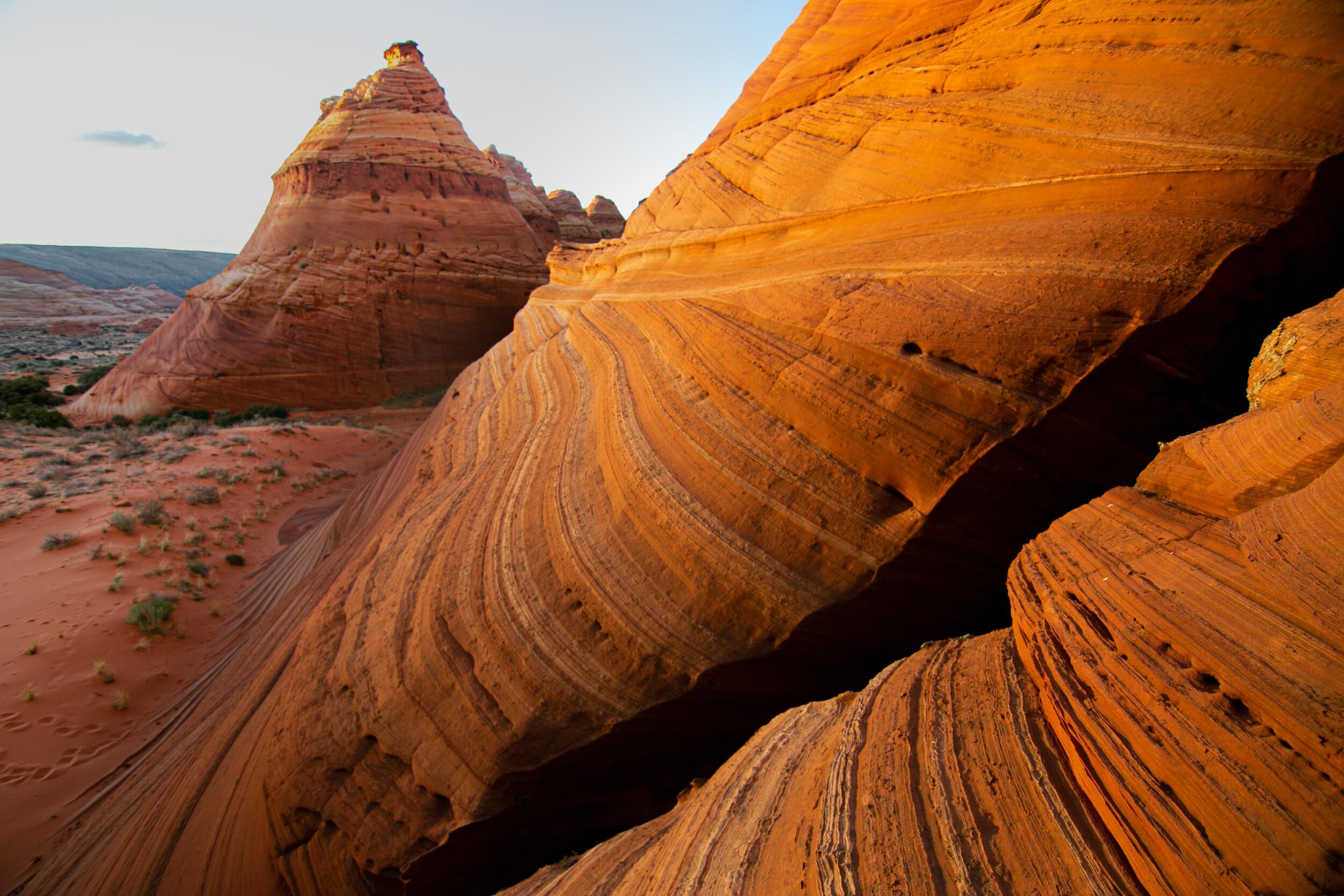
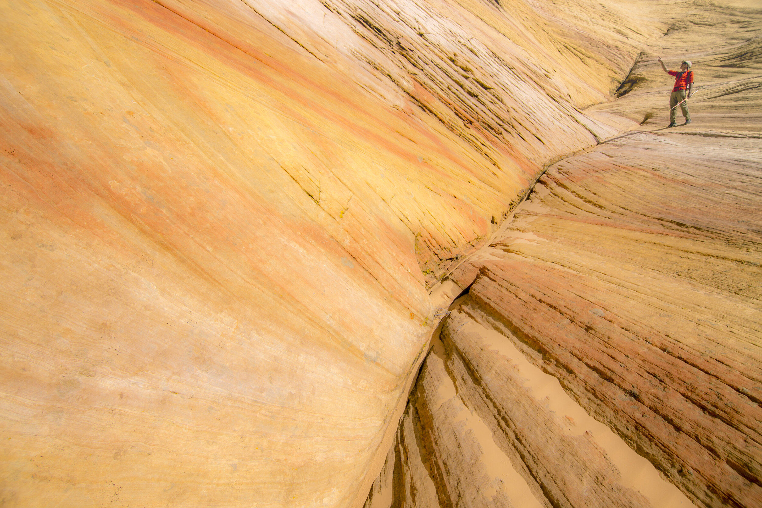
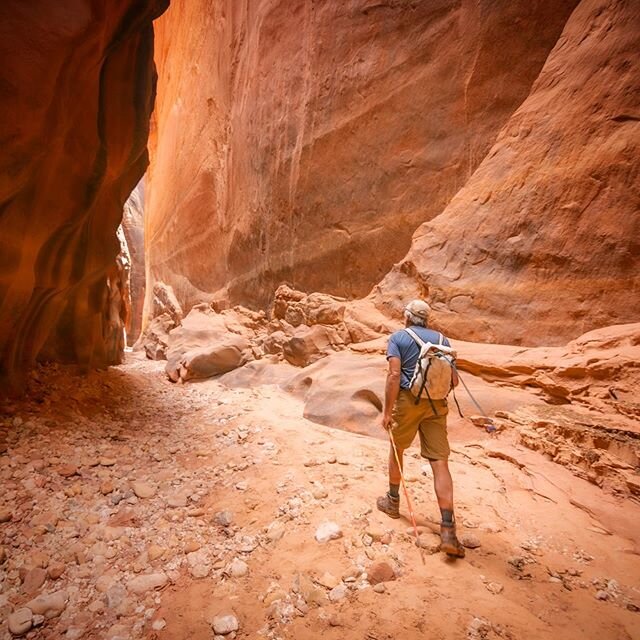
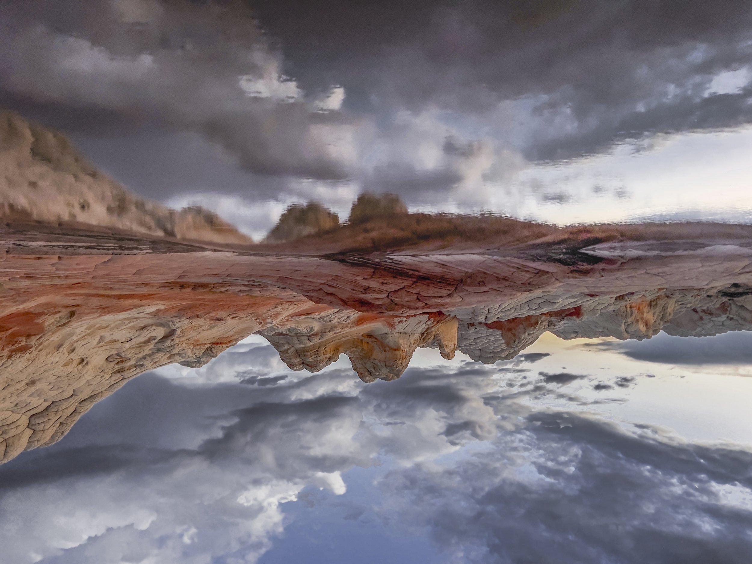
This is White Pocket, but might as well be The Wave!

Everyone asks. Here's how I think about it:

The Wave at Coyote Buttes North is iconic for a reason - it's visually singular, instantly recognizable, and the permit system (a daily lottery limiting visitors to 64 per day) creates genuine scarcity and exclusivity. If you win the lottery, go. It's a 6.5-mile round-trip hike through beautiful terrain to reach a formation that's about an acre in size. The Wave itself is extraordinary. The hike to get there is part of the experience.

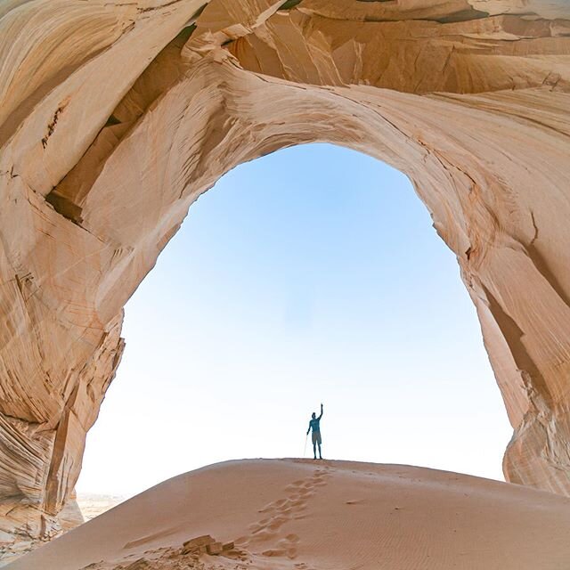
White Pocket covers roughly 20 acres - twenty times the area - with a greater variety of formations, colors, and textures. There's no permit required and no lottery. The trade-off is access: instead of a hike, you have a long 4WD drive. Instead of a single iconic formation, you have an entire landscape to explore without trails or markers.

My honest take: if you can only do one, the Wave has the edge for the pure "I can't believe this is real" single-image moment. If you want to actually spend time in a surreal landscape - wander for hours, find your own favorite formation, eat lunch sitting on 190-million-year-old rock - White Pocket is the better experience. They're close enough geographically that you can do both on separate days from Kanab, and I'd recommend exactly that if your schedule allows.

What to bring (self-guided)

A true 4WD vehicle with high clearance. A detailed map from the BLM office or Kanab Visitor Center. A GPS device - not just your phone, which will have no service. A tire pressure gauge and portable air compressor (you'll want to air down to 18-20 PSI for the sand and re-inflate before hitting pavement). More water than you think you need; a gallon per person is the minimum for a day trip. Sun protection - there is no shade at White Pocket. Sturdy shoes with good grip on slickrock. A satellite communicator like a Garmin inReach if you have one; if you don't, at least tell someone your plan and expected return time.

Do not attempt the drive if rain is in the forecast or has fallen recently. The clay and sand mixture becomes genuinely impassable when wet, and getting unstuck will cost you dearly - in dollars, in time, and in dignity.

A closing thought

Paul and I camped at White Pocket for our wedding anniversary. We didn’t choose a resort, or any of the national parks that are in close proximity of Kanab - instead, we decided to spend our anniversary on the slickrock, under the Milky Way, with a camp stove and a bottle of wine and no one else for miles. It's also the first place we take people. Whenever a friend or family member visits Kanab for the first time and asks what they should see, White Pocket is the answer before the question is finished. Not the Grand Canyon, not Zion, not any of the places with entrance fees and visitor centers and gift shops. White Pocket.

I think about why that is sometimes, and I think it's the scale. The Grand Canyon overwhelms you into silence - which is its own gift - but White Pocket invites you to look closely. To get down on your hands and knees and study a Moqui marble with wonder. To notice that the iron streaks change color depending on whether the surface is wet or dry. To find the one small alcove or flower-shaped rock formation that you missed the last 30 times.

The big landscapes get the magazine covers; White Pocket gets our anniversary.

Comment

How to finish (but not win) your first ITI 350

1 Comment

How to finish (but not win) your first ITI 350

Written from the perspective of a slow poke with a spotless finishing record.

PSA: if you love figuring stuff out on your own: don't read this - you'll walk away annoyed. That said, if you're the type of person who loves to do very, very hard things (like, say, the Iditarod Trail Invitational) with some semblance of expert guidance and the ability to do research instead of learning big lessons the hard way, this article is for you.

Why should you care about what I have to say?

Really, you shouldn't. In the end, every story from the Iditarod Trail Invitational is anecdata with an n of 1, and there are veterans who have amassed many more miles and finishes on the trail than my five completed missions.

But here's why I think my perspectives may be worth something, to some: I have five finishes out of five starts; I've done the 350 in all three disciplines - ski, foot, and bike; I successfully skied to Nome as part of the first ITI Nome ski finisher cohort, as a 1000-mile rookie in a year that brought pretty difficult conditions (2024). And - most important of all - I am decidedly not a super athlete.

I don't have crazy speed or endurance or the ability to push for 72 hours without sleep. The idea of running in snowshoes makes me nauseous. The idea of running any mile of the ITI course, honestly, makes me break out in a sweat. When it comes to bodily abilities, I'm a pretty average human among ultra racers. And I’ve gone into every single one of my ITI attempts with a meaningfully smaller training base than most other athletes (follow me on Strava if you don’t believe that statement.)

Which means the advice below isn't contingent on being exceptional; it just works.

A note on scope before we get into the thick of it: I'm primarily a ski and foot athlete, and my insights are most useful in those disciplines. That said, if you're biking and not racing for time, it's my riotous opinion that the bike is hands down the easiest way to reach McGrath... unless, of course, the trail disappears under several feet of snow, at which point it becomes a very expensive and very poorly performing rolling sled. For those circumstances, I’ve got no advice to offer.

So, without further ado: if you're on foot or skis with a physically and mentally strong finish in McGrath in your sights - rather than the podium - here's what you actually need to do.

1. Don't focus on going fast. Focus on sleeping.

I hear objections every time I say this: “I can't sleep during races // I don't have time to sleep // I want to be out the door early.”

To all of these I'll offer the same reframe - you sleep in regular life, and the ITI is, from a certain angle, just a very long vacation through Alaska's interior, so don’t think of it as a race but think of it as a vacation that happens to have a bedtime. On day five or six, somewhere past the Farewell Lakes, with your legs operating on whatever energy you can still scrape together at that point, your body will understand this in a way that's harder to access when you're fresh and well-rested and very confident about your race plan.

The competitive brain is extremely good at constructing reasons why the body's signals don't apply to you, specifically, in this race, given everything you've trained for. But the competitive brain, in my experience, is wrong about this with some regularity.

2. Sleep early, sleep often.

When your pace drops, it's not a sign that you're weak - it's a sign that something isn't working. Some causes are external and mostly immovable: bad trail, tough terrain, bad weather. For those, you adapt: right tools for the moment, appropriate layers, patience. But the more common culprits are internal and fixable right now, in this moment - sleep deprivation, calorie deficit, dehydration, any combination of the three. Pace collapses almost always trace back to one of these, and the fix is almost never to push through it. The fix is to stop.

The math on this is worth actually doing: grinding through 10 hours at 1.5 mph (which is a realistic proxy for SZP — Standard Zombie Pace) covers 15 miles; sleeping 4 of those hours and moving the remaining 6 at a restored 2.5 mph also covers 15 miles - and you arrive at that 15-mile mark in a condition where the next 10 hours don't look exactly the same as the last ones did.

I have played this game a lot over the years, and never more so than in 2026 — I slept six hours at Butterfly and, for a little while, was vying for Red Lantern honors. By the time I arrived at Yentna on Monday, I was in the thick of the field… except that some other foot folks at Yentna hadn’t yet slept at all, whereas I had banked six solid hours and was feeling great.

3. Be maniacal about your kit weight.

Stoked with good trail and light kit. In 2026 I weighed in at ~44 lbs fully loaded with food and water, one of my heavier setups; if I hadn’t packed at the very last minute, I would have been able to eliminate another 2-3 lbs.

If you're hauling more than 45-50 lbs for a McGrath run, you're doing it wrong - and I say this not as a slight but as an assessment of cause and effect. The reasoning that I hear is almost always some version of I want to be safe so I’m bringing extra gear mixed with I'm strong, so I can tolerate the extra weight, when the correct reasoning is I'm smart, so I'll figure out how to get the weight down without compromising my safety.

These approaches are not equivalent and they don't produce equivalent results. Having skied and hiked the trail with just a backpack, just a sled, and with a pack-sled combination, I have what I think is a reasonably calibrated perspective on how much sled & pack weight matters - how it compounds over miles, how it changes the feel of your body and feet somewhere around the 200-mile mark, how much of your will to continue on it quietly consumes without you noticing until it's already gone. Bikes probably follow the same logic, though I have less standing to claim authority on the wheeled side.

4. Eat. More than you want to, as much as you can.

There will be moments on the trail - usually starting on the Yentna River and definitely once you push into the Alaska Range, when everything hurts and your appetite has packed up and left for somewhere warmer - where eating feels like a chore and skipping a meal seems like the kind of minor concession that won't matter. It matters. You are burning far more than you can possibly replace, and every calorie deficit you run today will show up tomorrow as a pace collapse that feels inexplicable right up until you trace it back to the meals you didn't finish. My approach, for what it's worth: eat at every opportunity (starting at Butterfly!), eat more than seems reasonable for a person sitting still in a checkpoint, and eat right up to - but not across - the boundary of nausea. That boundary is real and it's worth learning where yours is. But operate near it.

5. Drink. And think harder about this than you want to.

At 5% body weight loss from dehydration, work capacity drops by roughly 30% - that figure comes from exercise physiology research (Armstrong et al., among others) and while the methodology debates are ongoing, nobody serious is arguing the effect isn't real. On a race where your average moving speed is 2.5 mph, where everyone else's average moving speed is also 2.5 mph, and where finish times come down to hours of difference accumulated over the course of a week or more - a 30% capacity hit is not a rounding error, it's an entirely different race.

The problem with the ITI is that the hydration logistics are genuinely challenging: water is heavy, containers freeze, and there are long stretches without reliable water access. My strategy is to compensate at the checkpoints rather than fight the in-between - load up thoroughly at every structure you pass through, carry enough for the stretch ahead and not much more. I do not carry a stove, but I am intentional with my hydration. Through the Burn I ran two liters with one 1-liter refill at Sullivan Creek, and that was fine - but only because I'd made a real effort in Rohn beforehand and was keeping Nikolai in mind the whole way through. Know your sources before you're thirsty.

6. Don't trust tracks in the snow.

Procure a GPS track, know how to read it, and check it at every junction - not most junctions, not the junctions that look ambiguous, but every junction. The trail has accumulated more than a century's worth of options for going the wrong direction, and your confidence that you're heading the right way is not, in itself, evidence that you are. I pride myself in my navigation, and I’ve done the trail five times… yet even I made three nav errors in 2026 because I was getting complacent and over-confident that I should now be able to navigate fully by sight rather than by checking my GPS.

7. Fret over three areas when it comes to temperature: your feet, your hands, your face.

Yes, you need to keep your core warm in order to have a shot at having warm extremities - but that’s the easy part. (If you’re worried about how to keep your core warm, you’re not ready for this race yet!) That’s why I want to focus on feet, hands and face - starting with the feet, because I feel strongly about this.

Most foot athletes are, in my view, dramatically undercutting their safety margin by choosing uninsulated GoreTex running shoes, and I understand the logic - light, breathable, proven over hundreds or even thousands of training miles. It works when conditions are reasonable and you're moving fast enough for your metabolism to keep you warm. But what about day three of -40°F in the interior, after the Alaska Range has done everything the Alaska Range does to a person, when your pace has dropped to 2 mph because you're simply too depleted to move faster and you are, by that point, past the kind of tired where you can will your metabolism to compensate? The uninsulated shoes stop being a performance tool and become a problem of a different category entirely. My recommendation: choose a boot that's warm enough to allow you to move slowly - because at some point on the 350, you will be moving slowly. My setup is the LOWA Renegade Evo Ice with a single mid-weight alpaca wool sock; that combination took me to Nome in 2024 and to McGrath in 2026, over 1300 miles of some of the coldest trail on earth, without a single moment of genuine concern about my feet. I’d argue that, for a race that has frostbitten better athletes than me, that outcome speaks for itself.

For your hands and face… just don’t get complacent. Warmer gear doesn’t always lead to less frostbite risk - remember you are optimizing for moisture management first, and warmth second. Case in point: I crossed the Alaska Range in 2026 with nothing but thin Seirus Heatwave liner gloves and lightweight Yama Pogies; I didn’t even have to use handwarmers (though I did put my poles away for long stretches at a time so I had the option of putting my hands into my jacket pockets).

Another pro tip for a piece of gear that I trialed during the 2026 Rainy Pass crossing for the first time: Tempest Optics heated goggles proved to be worth their weight in gold.

8. Get smart on weather data, and use it.

Know where to find forecasts and current conditions for each section of the route before you need them - not after you're committed and already standing in whatever's coming. (If you’re not sure where to start for nuanced backcountry forecasts, wind speeds etc, ITI vet Jonathan Chriest is a professional metereologist and hosted a free webinar on this very topic.)

The worse the forecast, the more tips 1 and 2 apply; the Alaska winter doesn't negotiate and has no particular interest in your timeline, and the less well-slept and well-fed you are the more prone you are to making mistakes and getting yourself into trouble. Your job is to have enough information, early enough, to make a reasonable decision about when to push and when to be patient. Getting that call wrong on a benign stretch of trail is uncomfortable. Getting it wrong in the Alaska Range, in wind, at the wrong temperature, is a different category of problem.

9. Fix it now.

Not at the next checkpoint, not once you get to the trees, not in a few miles when maybe it'll resolve on its own. Now. The logic of I'll just get to the corner and then deal with it feels like discipline - it feels, in the moment, like being tough - but it is almost always false economy, and the trail has a way of making this very clear by the time you arrive at that corner. Fixing a hot spot costs 5 minutes and essentially nothing in performance. The same hot spot, four hours later, has become something that costs you days. For anything that might involve cold injury - cheeks burning, hands having lost sensation to a dangerous level, toes freezing - "now" means right now, before the next step. For everything else, as soon as you can stop without creating a cold exposure problem in the process. There is no version of this race where waiting made a small problem smaller.

10. Have a plan. Hold it loosely.

You will start with a plan - a daily mileage target, a checkpoint schedule and, after reading this article, hopefully a sleep strategy you've thought through carefully and are quietly proud of. That plan is useful. It gives you a framework for the first day or two, and a reference point for everything after, which is when the trail will begin systematically dismantling it. Conditions change; your body doesn't perform the way it did in training; the weather has opinions. I believe that the athletes who struggle most are usually the ones gripping the original plan after the plan has stopped applying - those who are behind schedule and responding to that by pushing when pushing is the wrong call. What the trail actually asks of you is continuous adjustment: listening to your body, reading the conditions, recalibrating what "a good day" looks like given what's in front of you right now rather than what you mapped out at home. The plan is a starting point; the trail is the conversation.

There’s another element that factors in here: race your own race and don’t get sucked into the false sense of safety that comes from being part of a pack. Traveling in groups can be a nice morale boost and combat monotony, but outside of those two factors it makes everything harder - optimizing your pacing, layer adjustments, sleep schedule, etc etc. I understand the desire of having folks in your proximity but I do not believe that traveling in a pack is a success strategy (I wrote about Sarah’s and my 2021 experience here). If you do want to coordinate with other racers, I would recommend a leapfrogging strategy and checkpoint socials rather than true trail companionship.

And then there's the ultimate factor - the thing that isn't in any packing list and can't be borrowed from someone else's race report. Somewhere out there, probably not at a moment that announces itself as significant, you will have to decide that you are going to finish.

This is not the decision you made at the start line; that one's easy, and it doesn't really count. The one you make later, when the math has stopped adding up and everything hurts and the trail has made a fairly persuasive case for why stopping would be completely reasonable and is, in fact, the rational thing to do (spoiler alert: the rational thing is to never attempt a race like this in the first place). That decision to finish is the race. The nine tips above will get your body to that decision in the best possible condition. What you do with it is yours.


Casey B, a fellow 350 racer said to me this year somewhere in the middle of the Happy Steps: I hope you're finding what you came out here looking for. I've been turning that over ever since, because it's exactly right and also somewhat impossible to answer. The ITI is an entirely elective, entirely irrational pursuit - it costs money, it costs time, it has, in some years, cost people fingers and toes and more than that. It is hard to explain to anyone who didn't already want to do it. But if you do want to do it - if something in you has been tugged toward Alaska and the cold and the particular silence of crunching snow at 3am when no one is around for miles - then the things that will get you to McGrath are simpler than it seems: calories, sleep, water, boots that are warm enough, a GPS track you actually check, and the willingness to adjust when the trail asks you to. The rest of it - what you came out here looking for - the trail will handle that part on its own schedule, in its own way, whether you're ready for it or not.

1 Comment

5 Things I Wish I Had Known Before Planning An Expedition To Baffin Island

Comment

5 Things I Wish I Had Known Before Planning An Expedition To Baffin Island

Baffin Island. If you’re not a climber, arctic adventurer, or Northerner, you might be scratching your head: where on earth is that?

If you are a climber, you know that Baffin Island is, well… Baffin Island. Granite domes, towering sea cliffs, big rivers and even bigger glaciers: the land of giants.

The heart of the Weasel Valley: Auyuittuq National Park, Baffin Island (Nunavut, Canada)

I don’t remember when I first learned about Baffin Island. I do remember that, as soon as I saw those photos of mystical ice, rock, and solitude, I knew that I had to go. Years later, I met my now-husband Paul, who regaled me with his wild tale of adventure and survival in Baffin’s Sam Ford Fjord that almost cost him his life in 1995. Fast forward another decade, and Paul and I turned my long-held dreams of visiting Baffin into a summer expedition to celebrate our respective 40th and 65th birthdays. Without much discussion we zeroed in on Auyuittuq National Park and the Weasel Valley, arguably the epicenter of established (and exploratory) rock climbs in Baffin Island.

Approaching Mount Asgard and Loki

We spent three weeks in the backcountry, savoring our presence and humanity amidst the stark beauty of the arctic.  Our time in the Weasel Valley was over before we knew it; as we exited the park, we both knew that we could easily have stayed for another three weeks.  Our adventures, and what happened in those three weeks, is the topic of another story, but in the meantime I want to capture some of my travel planning & logistics insights before they slip from memory. 

Here is what, in retrospect, I wish I had known about traveling to and in Baffin Island before we planned our expedition. 

  1. Auyuittug National Park and the Akshuyak Pass Traverse is a bucket list item for passionate hikers.  Even though the area is incredible remote, the park’s short summer season and its bucket list status means that high-season travel equals a high likelihood of encounters with other groups including large guided groups. On most days, we only saw two or three other people; but we also had a day where we were dodging three different large hiking and climbing groups that totaled a whopping 24 people. Peter, one of the two local outfitters in Pangnirtung and a former park ranger, estimated that some 300 visitors came to the Weasel Valley in the 2025 season the majority of whom hiked the Akshuyak Pass Traverse during the late July - mid August window.

  2. To approach Auyuittuq and the Weasel Valley you’ll need to either fly to Pangnirtung - the hamlet at the mouth of the fjord south of the park, best for the Weasel Valley, Thor, Asgard & Summit Lake - or Qik(iqtarjuaq) on the north side of the park. Qik provides access to the Owl and June Valleys and is the traditional starting point of the Akshuyak Pass traverse. To get to either of those small hamlets, you’ll first need to fly to Iqaluit, the capital of the province of Nunavut, which, in turn, is typically accessed from Ottawa. Lodging in all of the Northern communities is extremely limited and everything, from rooms to groceries to restaurant meals, if available, is very expensive - which makes perfect sense, given that all goods have to arrive by air. This also applies to Iqaluit, which we found to be even more expensive than Pangirtung.

  3. Summer boat access to the park is dictated by spring breakup, the period at which travel on the sea ice by snow machine is no longer possible but the water isn’t yet open enough for travel by boat. Breakup can run its course as early as June or as late as the end of July. In 2025, the first day of Weasel Valley boat access from Pangnirtung was July 7. Hiking from Pangnirtung to the southern border of Akshuyak National Park looks plausible but would add a minimum of 20 miles (likely 3+ full days of hiking) to any trip, and take you to the east side of the Weasel River which is the less popular side of the Weasel Valley though it would provide direct access to prize peaks like Ulu and Mount Thor.

  4. Everything in the Weasel Valley is a lot bigger than it looks. Mount Thor, at first glance, inspires comparisons to Half Dome - yet it is almost a full two miles wide at its base, and twice (!!) as tall as its Yosemite ‘baby brother.’ At the same time, what looks like a comparatively small moraine, may actually have an elevation gain of 1,000ft or more; facing a 2,000ft+ ascent through moraine hell (or, as I ended up dubbing it: more-anal activity) to gain a glacier basin is not unusual.

  5. The small Northern communities of Pangnirtung and Qikiqtarjuaq are frequently weathered in, which means that flights in and out are subject to weather cancellations. From conversations with locals in Pangnirtung we learned that Northerners know this and follow two simple travel rules: one, always book directly with Canadian North; two, don’t plan anything for the first six days following your intended return date.  Yep, you read that right: give yourself an entire week’s grace period.

    We unfortunately did not follow this strategy: having booked tickets from Las Vegas to Iqaluit on booking.com and a separate roundtrip from Iqaluit to Pangnirtung directly with Canadian North meant that we had to buy all new - VERY expensive and late - tickets when our cancelled return flights from Pangnirtung made us miss the booking.com return leg from Iqaluit to Las Vegas.  Our original itinerary had us arriving back home on a Monday; instead, the Pangnirtung —> Iqaluit cancellation led to us having to spend five additional nights in Pangnirtung, Iqaluit and Ottawa. We did not make it back until the following Saturday (surprise: the locals were right with their guidance of budgeting a six day travel grace period), and had to spend >$2,500 per person for our new return flights.  Lodging & food expenses for the additional week on the road easily surpassed another $1,000 per person due to the high cost of living in the North.

What’s my takeaway? Baffin Island, specifically the Weasel Valley, may be a little bit more “on the map” than I had originally anticipated — but that doesn’t make traveling here any less of an adventure.  I have no doubt that I will be back one day, possibly at an earlier time of the year to experience more cold and solitude, and possibly with a visit to less sought-after and *even* more remote areas than Auyuittuq’s Weasel Valley. 

Auyuittuq National Park IS remote and you’ll encounter few other visitors - but 90%+ of all those who do visit the park spend their time in the Weasel Valley.

Comment

A Chair at the Table of my Better Self

1 Comment

A Chair at the Table of my Better Self

I gingerly place my feet on the ground and shift my weight onto my right leg.  A polite ache flares across the outside arch—an amiable three out of ten this morning, and that’s without chemical diplomacy. Earlier this week that same spot was a constant sulking six or seven, even under a gram of naproxen.

“Earlier this week” is when I had just wrapped up a forty-three-mile, all-night wander through the Superstition Mountains - just one line in a two-week, 500-mile poem strung along the Arizona Trail. Why? First, because I love hiking and being outside. Second, because I was trying to break the speed record for the fastest unsupported completion of the entire 800 mile Arizona Trail. 

I’m no stranger to endurance efforts. I’ve set speed records around the Annapurna Circuit, on Aconcagua, and in the Grand Canyon, amongst other places. In 2024 I became the first woman to complete the 1000 Mile Iditarod Trail Invitational in Alaska on cross-country skis. I spent the better part of a decade earning my chops as an ultra runner with 100 miles finishes at races like Western States and the Ouray 100, and I earn my living as a mountaineering and backpacking guide living in close proximity to the Arizona Trail’s northern terminus.  So it seemed only natural for me that I’d want to try my hand at a speed record on the trail, and, in fact, this wasn’t my first rodeo: I’ve tried twice before. 

My first attempt, in the fall of 2023, was a supported effort — I had crew, pacers, no need to carry anything other than a light layer and some snacks and water, and I was trying to go FAST; 50-miles-a-day type of fast.  That worked for a couple of days, until it didn’t: I sustained a stress fracture on Day 4, and eventually admitted defeat and stopped running (or rather, hobbling) on Day 7 after 309 miles. 

My second attempt came in the fall of 2024; this time I was emboldened by my success on the Iditarod Trail and inspired by legendary speed hiker Heather Anderson (Anish) who had just nabbed the outright unsupported record at 24 days 1 hour and 12 minutes, so I decided to try the unsupported style.  That meant I would carry all my food and gear for the entire length of the trail: 800 miles with no resupplies, save for water refills from natural sources and public spigots. Anish’s record translates to right around 33 miles per day; I was optimistic that I could develop a strategy to cover more ground each day than that, even loaded with gear and food for 800 miles. 

How did that attempt go? My pace and fuel strategy were on par, but my head wasn’t in it - at all.  When I saw the lights of Flagstaff after 200+ miles and a cold, dark, lonely week on the trail, the only thing I wanted to do was go home; so that’s what I did. (You can read more about that decision here). 

I wasn’t sure at the time if I’d ever want to try again, but weeks passed, my fortieth birthday drew closer, and the trail’s siren call kept slipping into conversations that I had with myself.  So I decided to make time for a third attempt as a birthday present: spring instead of fall, warm sun instead of frost, longer daylight, less premeditated storytelling around it all. Yet even as I carefully packed my gear and once again prepared food for 800 miles, I couldn’t tell whether I was chasing closure or genuine desire.

But for fifteen days and nights the trail and I traveled well together. My kit weight shrank with every meal, my pace held steady, and, most precious: I felt unrushed and present. My solar panel went on strike within the first few days which quickly meant no earbuds, no podcasts, no music. Instead, time in my head and with memories that I rarely get to see, with my dead parents and the long-lost peace of loving childhood moments, set to the backdrop of birdcall, footsteps and the whisper of the wind. Somewhere south of Pine, though, a few unseasonably rainy days translated into damp and dirty socks which, paired with a long and rocky downhill, brewed mild trench foot and eventually a deep blister that then turned ugly. By the time infection started whispering threats, I tried everything I could - from rest to minor surgery to medication - but I finally had to bow my head and hiked out, catching the ride home I’d hoped not to need.

Which brings me back to this morning’s tentative step on my healing injury: a reminder and a souvenir. 

I returned home with a surprise gift wrapped inside the low-grade disappointment having learned, beyond doubt, that I wanted to be out there and that I still can and want to do hard things. I was strong, I was moving well, but more importantly I was at peace and where I was supposed to be—fully present in a way that I find hard to hold on to in daily life. The Arizona Trail welcomed me with open arms this time, offering a chair at the table of my better self. I hiked for days without being distracted by my phone or songs or podcasts, and I felt myself returning closer to the best version of myself with every mile I walked.  

My biggest regret is not that I didn’t manage to break the speed record or even complete the trail. Instead, it’s that a seemingly small carelessness - dirty socks in warm wet weather with big downhill miles - spiraled into a soft tissue injury that cut short my immersion in that sweet bliss of presence and alignment that the trail gave me for my birthday. 

Here’s the irony: three exits in three tries, yet I believe more than ever that I can break the unsupported record, all while realizing fully well that confidence without evidence grows thinner with repetition - and so does my credibility.  

But the speed record also isn’t really what I am after; it’s the mindful presence and alignment that I mentioned earlier. Why try for a speed record at all then? Because what I really crave is that sanctity of the convergence of effort, uncertainty, and accountability where the mind goes quiet. A speed attempt is simply the most direct doorway I’ve found.

So: has the Arizona Trail already given me everything I came for, or do I have unfinished business?

All I can say is ‘Yes’.

With big adventures like this one on the Arizona Trail, I am raising funds to help create transformative outdoor opportunities for women and girls and support get OTHER women into the outdoors. If you enjoyed reading this article, please make a donation here.

1 Comment

What’s the meaning of it all?

Comment

What’s the meaning of it all?

Very Long Distances, Fastest Known Times, Difficult Pursuits, Speed Records and Firsts and Fastests.  That’s what I’ve dabbled in for the better part of the last decade, and I’ve done some rad stuff.

When I was on the brink of thirty, I had it all: an MBA from Harvard Business School; a fast-paced, high-impact job at Bain & Company; the sizable paycheck that came with it; a beautiful apartment, nice things, a partner in the same line of work; and the ability to travel all over the world not just for work, but also for play.

All I wanted back then was to not be glued to a screen and be outside instead. I wanted to experience epic adventures that would be worth telling stories about.  I wanted to go farther, faster, higher, more remote. And I did. I quit my life and moved into a $3,000 Chevy Astro van to ignore money and status and achievement and make adventure primary. 

100 Mile Races. Big wall climbs on Yosemite’s El Capitan. Speed records in the Rockies, the Himalayas and the Andes. The first woman to complete the 1000 Mile Iditarod Trail Invitational on skis. 

The tag line of my website said - #purejoy. In retrospect, I wonder if it should have said: #puregoals. 

I thought I was running from status and achievement. I told myself that I was seeking immersion in adventure so that I could slow down and leave behind the burnout that my time as a strategy consultant had catalyzed. But that’s not the story. 

I have learned that I can do hard things, and that doing hard things in and of itself is meaningless.

Ten years later, what I want has changed yet not at all.  Today I’m on the brink of forty, and still all I want is to not be glued to a screen and be outside instead. I still want to experience epic adventures, adventures that are worth remembering. I still want to go farther and more remote; the ‘faster, higher’ bits don’t matter quite as much now, for me at least. 

Yes, I have successfully completed some unlikely missions that live in the record books - and I have withdrawn from just as many, because they felt trivial and empty. I have learned that I can do hard things, and that doing hard things in and of itself is meaningless.  What creates meaning, for me, is community, discovery and growth. I seek purpose, connection, and novelty - not just difficulty and competency.

What role does adventure play in your life?

————-

Adventure has changed my life, and through adventure I have touched the lives of many others. Through story telling, yes - but also as an advocate, an expedition leader, a business owner, as a guide, an employer and a mentor. I believe in the power of adventure to catalyze growth and joy, which benefit not just the adventurer but also those around her.  When we play outside, we get better.

Comment

I pulled the plug: my Arizona Trail speed record attempt is over

16 Comments

I pulled the plug: my Arizona Trail speed record attempt is over

I came off the trail in Flagstaff, at Mile 208.5 - almost a hundred miles earlier than last year.

What went wrong?

Nothing.

This is the difficult truth: I had no reason to drop out.

I made it across the Grand Canyon, and through the high country of the San Francisco Peaks with their early snow. Despite taking a nero (nearly zero) day to recover from the difficulty of climbing out of the Grand Canyon with heavy weight, I was a mere two miles behind record schedule - and on track to be comfortably ahead of record pace within just one more day of walking. Yes, a lot can happen over 590 miles and two additional weeks of trail time, but the nature of an Unsupported speed record suggests that you should get faster over the course of the attempt rather than slower.  That’s because your initially insane food weight diminishes with every passing day, eventually leaving you with nothing more than a lightweight backpack. As long as you find a way to not break yourself, your energy levels, or your gear, during the first half of an unsupported long-distance hike, the miles towards the end become lighter and more manageable.

How did my energy management fare? I had been sleeping plentifully, and mostly well. My food plan was on point - I ate each day what I was supposed to, all 4,500 calories of it, never bonked, and never went to bed hungry. I haven’t yet had a chance to weigh myself but I think I didn’t lose a single pound in this 200 mile week; the ultimate testament to fueling appropriately.

So what went wrong?

Did my gear break? No - with a few minor issues everything worked beautifully.

Did my feet hurt? Yes, but not any worse than in other long adventure; when I skied the Iditarod last year, my heels turned numb with nerve damage starting at Mile 150. I skied another 800 miles on those feet, all the way to Nome. It took two months for the feeling to come back.

Did my weight carrying strategy not live up to its promise? Scared of what carrying 60+ pounds for big miles each day would do to my hips (and to my energy levels), I ran a big experiment by putting wheels behind me and dragging, rather than carrying, most of what I needed for this Unsupported speed record attempt. It worked beautifully. As I already knew from skiing some 1300 miles in Alaska with a sled over the years, pulling a load behind you is much less energy consuming than carrying it on your back as long as you’re in the flats. Add hills, and any pulled item feels like an anchor five times heavier than it truly is. This is what my experience here was, too: pulling the cart worked beautifully in the flats, even on rough trail. The uphills - like climbing up the Kaibab Plateau, or going across the San Francisco Peaks - made me work for it, but my energy expenditure was still WAY lower than heaving all 67 pounds of kit up the South Kaibab trail in the Grand Canyon where wheels are prohibited. So, yes, the system worked. Better than expected even, allowing me to go hands free on the cart across burly boulders, and running so beautifully and effortlessly that I at times I found myself breaking into an easy jog on mellow trail all while “carrying” still right around 60 pounds!

So why did I drop out?

One simple answer.

My heart wasn’t in it. I didn’t feel the magic of the trail. I wanted to stop each day not because I was exhausted and couldn’t go any further, but because I was bored. (My 18 hour portage across the Grand Canyon was the notable exception to that statement - each step was a struggle on the climb out of the canyon.)

Three weeks is a long time to spend away from home and your loved ones. I was missing mine direly each day, much more so than on other adventures, and I felt lonely and sad much of the week that I spent walking the first 200 miles of the trail. These feelings inevitably intensified during darkness, of which there was a lot: with the sun setting at 5:20pm, and my days usually ending between 10pm and midnight, I had lots of nighttime hiking. I am not scared of the night, nor am I scared of being alone - I’ve had plenty of both during past adventures. This time was different. I was sad.

I often get asked how I managed to push through 30 days on the Iditarod Trail and find the mental fortitude to not give up. My answer was this: I was present, in the moment, and when I thought about what I would do with the time I could “get back” from dropping out early… I realized I didn’t want that time back. I wanted to be on the Iditarod Trail, immersed in the adventure, experiencing the growth. I only started to feel a bit over it all in Alaska on Day 26, once I was within shooting distance of the finish, and knew with some confidence that I had a reasonable chance of actually doing the thing.

My time on the Arizona Trail was the exact opposite. Yes, I walked into it excited for the adventure and hoping that the version of myself who left the trail would be different, more capable and reflected, than the version who stood at the Northern Terminus on November 11 ready to start. Once I was walking on the trail, though, my head was swirling with so many thoughts that took me farther and farther away from wanting to be there.

The long hours of self-imposed aloneness so close to home: the AZT starts an hour from where Paul and I live in Kanab. The first 200 miles had me feeling like I was camping in the backyard of my family home on a cold dark night, longingly looking at the warm glow of the living room window lights yet barred from going in.

The memories of last year’s Supported (and aborted due to injury) attempt, where I had an amazing group of crew and pacers and friends watch out for me and accompany every step of the journey. The beauty of that experience, and its social component; such a stark contrast to this unsupported attempt.

The fact that I was excited to see the Southern portion of the trail, but that I was going to pass through 1/3rd of it in darkness without actually getting to see the landscape I was traversing.

The utter arbitrariness of the Unsupported handicap, in general and per Fastest Known Time rules. You may charge your electronics at public outlets, and throw your trash away, but apparently not sleep in a designated campground. And why did I decide to carry all my food from the start again, when there are resupply options along the way… just to prove I can?

And, the conversations around gender equity that my AZT fundraiser stirred. “What the heck is gender equity in the outdoors?” and “Women are doing rad things outdoors, we have gender equity already.” The reactions that my fundraiser announcement drove on Facebook made me realize just how far removed my immersion in this topic is from the mainstream conversation, and how much better I have to get at articulating why it all matters.

The work that I need and want to be doing right now is not to walk 35-40 miles a day so that I can pat myself on the back at the end of the trail and say “I did it”. Folks are right: there are women out there doing rad stuff; I am one of them; so is AZT unsupported record holder and ground breaking speed hiker Heather Anderson.

What I want and need to be doing right now is not to prove once more that I can do rad things; it’s to put words and logic and a call to action to the topic of what role gender plays in outdoor adventure, and how outdoor adventure is a catalyst for gender equity that reaches far, far beyond the trails, the mountains, or the seas.

So, yes: when I was skiing the Iditarod Trail I knew that I was where I wanted and needed to be, and that there was nothing else I wanted to be doing instead. Here, on this second Arizona Trail speed attempt of mine, I have come to realize the opposite: there are a hundred things (and two or three among them that are truly meaningful) that I’d rather be doing with my time. Instead of spending two more weeks on the trail in pursuit of yet another arbitrary accomplishment, I WANT that lifetime back - to spend with Paul, and to do work that matters.

Thank you for following along, and thank you for your support of the fundraising campaign for gender equity in outdoor adventure. I may not have walked the Arizona Trail to its finish, yet I don’t consider this a dropping out - I am withdrawing from this speed record attempt so I can choose to walk a different path, towards a destination that bears more significance to me, and to many others, than the Arizona Trail’s Southern Terminus.

16 Comments

Practical Advice: the R2R2R-Alt

3 Comments

Practical Advice: the R2R2R-Alt

The Grand Canyon’s Rim-to-Rim-to-Rim (R2R2R or R^3) has turned into a trail runner’s rite of passage: dozens if not hundreds of R^3 hopefuls descend upon the corridor trails every spring and fall weekend. This 42-ish mile double-crossing of the big ditch is hardly a big deal anymore. Many locals consider the Rim-to-Rim-to-Rim simply an enjoyable jaunt in the park; Germany native and Santa Fe resident Gerd Nunner celebrated the completion of his 100th Rim-to-Rim-to-Rim in 2018, at the age of 65.

March 2013, before my first-ever R2R2R. So many things I had to learn… (and still do)

I myself have a long history of being infatuated with the Grand Canyon, and I remember well when I ran my first R^3 ten years ago: it was momentous. I set out on the Rim-to-Rim-to-Rim in early March, when the North Rim was buried under several feet of snow and there was no car access to the North Kaibab trailhead. This was my first non-race ultra run. It was my first big “backcountry” mission, the first time I set out on unknown trails, and the first time I dared to attempt by foot something that was beyond the reach of any vehicle.

I remember running into Gerd, the aforementioned 100x (or more) finisher of the Rim-to-Rim-to-Rim, with whom I bonded over our shared German heritage and love for the canyon. Gerd was already on his return journey to the South Rim when I was still climbing up towards the snowbound elevations of the North Rim; he insisted that I borrow his microspikes to navigate some treacherous iced up sections.

Well - that was in 2013 when I had barely started to develop my identity as an endurance athlete. Now, in 2023, I am a professional adventure athlete and co-own a premier hiking and backpacking guide service in Kanab, some 65 miles north of the boundary of Grand Canyon National Park. I have hiked, run, scrambled and rafted and guided 100s of miles in the Grand Canyon, and while I still think that the corridor trails are a magical playground for Grand Canyon first-timers I am now much more interested in the utter solitude and remoteness that the canyon has to offer once you venture beyond the crowds of the corridor.

After 80 “fast” miles on the Tuckup with Ashly Winchester

That’s why, in late 2021, I completed a single-push effort on the Tuckup Trail with my friend Ashly (read more here or watch the short movie).

It’s also why, in late 2020, I set out on the Rim-to-Rim-to-Rim’s obscure cousin with my friends Christin Randall and Lexi Miller: together, the three of us became the first women to post an official time on the so called R2R2R-alt, which is a wild and remote double-crossing of the Grand Canyon along the North and South Bass trails the trailheads of which are many dirt-road miles west of the popular and easily-accessible corridor trails. The kicker for the R2R2R-alt though is this: there is no bridge across the Colorado River, which means that you have to boat or swim the river twice in order to complete this double crossing.

Swimming the Colorado River at the bottom of the Grand Canyon is a big deal for a few reasons.

  1. You can’t just get in and out of the river anywhere - most of this section of the Colorado is guarded by steep cliffs, so you have to get it right (which is complicated by a strong current)

  2. The water is extremely cold and bound to trigger a cold shock response

  3. You are swimming the Colorado in between two major rapids

Those are the reasons why I initially had second thoughts about going for the Rim-to-Rim-to-Rim alt, and why I was glad for the company of Christin and Lexi (and her pack raft) for our initial attempt. Yet after Christin, Lexi and I safely completed our R^3-alt in a little over 22 hours in 2020, I knew that I was going to return at some point without company and without the psychological security of Lexi’s pack raft. It’s what brought me back to Swamp Point, the jumping off point for the Bass trails on the North Rim, in late October 2023.

Christin, Lexi and I during our team FKT on the Rim-to-Rim-to-Rim alt. Christin and I swam, Lexi pack rafted (and helped majorly with shuttling our gear and serving as spotter).

When I returned for the R^3-alt by myself I had a few elements going against me. I was utterly untrained; I had an extremely short window to squeeze in a good adventure between work obligations; and the temperatures were forecasted to plummet. Superficially, cold weather may seem like a good thing for this particular canyon route knowing that heat is a major and very dangerous obstacle in the inner canyon - but in this case, there was a NOAA freeze warning issued even for the low elevations of the Colorado River; and the idea of swimming brutally cold water in below-freezing air temperatures certainly gave me pause.

On the upside I had some elements going in my favor: I was (somewhat) familiar with the route; I had done the swim before. And, thanks to regular cold immersion at home, I was a lot more prepared for cold water than I had been during our first attempt. I also came in with a different strategy: where before we were hell-bent on having daylight for our swims across the Colorado, I was now a lot more comfortable with the idea of being in the water in the dark. That simple mindset shift allowed me to start down North Bass trail much later in the morning (6:00am in 2023 vs 2:15am in 2020), which saved a lot of nighttime navigation trouble in rough terrain.

With my new strategy, despite moving very slowly and taking alllll the time to smell the roses and take lots of pictures, I was able to lower then women’s speed record on the R^3-alt by over two hours.

The first time Christin, Lexi and I completed the R2R2R-alt, I told Runner’s World that I wouldn’t be shocked if someone were to die on it. That statement still holds true, but as the R2R2R-alt gains traction in the endurance world I want to share what I know to help demystify the river crossing for those adventurers who are capable of attempting this route - in the hopes of helping to introduce an element of understanding into what is a high-consequence endeavor. As such, here are my detailed recommendations about how to approach the river crossing.

The River Crossing: Step-By-Step Instructions

To swim across the Colorado River safely, you need to be cognizent of three different factors: temperature, river access, and gear.

1) Water Temperature

The water of the Colorado River at the bottom of the Grand Canyon is extremely cold. Why? Because the river is fed by dam release from Glen Canyon Dam at the downstream end of Lake Powell, meaning whatever water “enters” the river comes straight from the dark, cold depths of Lake Powell above Glen Canyon damn. Usually, the water temperature of the dam discharge ranges between 45 and 60 degrees. The lower the water level in the lake, the easier it is for the sun to warm the water - which is why, in October 2023 (when I completed my Rim-to-Rim-to-Rim alt), the dam discharge temperature was hovering around 60 degrees - a good 5-10 degrees warmer than during our previous run in 2020. The significance of this temperature variability cannot be underestimated.

With water in the 50 or 60 degree range, the cold isn’t merely a question of discomfort; instead, it will trigger the body’s involuntary cold shock response which, if not anticipated and managed properly, can cause drowning. I myself experienced cold shock during my first swim in 2020, despite wearing a full 3mm wetsuit. I wasn’t ready for it, and it was incredibly scary.

In my mind the water temperature is the single biggest risk factor for the river crossing. How do you address this risk? One, time your adventure such that you are not swimming at the coldest time of the year. Two, train for cold water: I found a practice of cold showers to be helpful; Wim Hof breathing surely would be beneficial as well. Three, anticipate cold shock and know how to work through it.

Dam release temperatures over time. This USGS site has all the dam release data you might want (water temperature, flow rate etc).

To monitor water temperatures at Glen Canyon dam, use this USGS link. Note that the data shows water temperatures at the dam varying seasonally by as much as 25 degrees (with a low of 45 degrees and a high temperature of 70 degrees). Timing your adventure to avoid the months with the coldest water temperature, i.e. springtime, is wise.

A word on flow: my primary concern before my first lap on the R^3-alt was the river’s flow rate. I assumed that it would be beneficial to time your river crossing with the lowest possible flow, translating to the least amount of current. I have since come to believe that, barring a major flood event, temperatures are a lot more important than flow rates. Regardless - check the USGS gauges to understand flow rates prior to embarking on this adventure, and, once you reach the river, trust your senses: don’t commit to the swim if the river is higher and faster than your confidence level!

2) River access - GPs coordinates

Prime swim route for a north-south-north R^3-alt. If starting the R^3-alt from the South you may have trouble locating the Bass Cable access from above.

Within the context of the Rim-to-Rim-to-Rim alt, the Colorado River is guarded by steep cliffs on both its north and south shores. Getting in and out of the river is one challenge; getting from river level to the trail is another challenge. The major beaches that are visible on satellite imagery are located right below Bass Rapid and right above Shinumo Rapid, which may be convenient for boaters but less than ideal for swimmers.

Having completed this swim twice now, I believe that these access points on the north side of the river are prime:

  • North side launch gully: 36.23434, -112.33992

  • North side exit beach: 36.23702, -112.34230

On the south side, I use the gully of the Bass cables located at 36.23500, -112.34162 as both entry and exit. This south side access point is a little tougher to get to than its counterparts of the North side, and it may be difficult to locate if you are doing this route starting from South Bass trailhead. If you are swimming across from the North, the old Bass cable infrastructure is an obvious visual marker at river level for where to aim for.

South Bass river access scramble. There may be another south side access location that is easier to get to without forcing you into white water or major detours from the trail, but I haven’t found it.

Spot the old Bass Cables on the right-hand side of the shot? This is what I am for when swimming from the North side.

Gear

After two slow but successful R^3-alts I feel like I finally know what kit is appropriate for this adventure. Here’s what I would recommend in addition to your standard 42-mile remote ultra trail setup - which of course needs to be conditions-appropriate and, in my opinion, should include a lightweight emergency bivy, some form of water purification, and GPS communication.

Part of my R^3-alt gear kit. Fins: A+, though next time I’d bring an over-the-shoe model. Swim cap/goggles: not needed if swimming with fins & flotation. Swim buoy/dry bag: too small!

  • Kick fins that you can wear over your trail shoes - this will make a huge difference in the amount of energy you have to expend to get through the current. Being able to keep your shoes on with the fins saves time and makes the entry/exit that much easier. Look for fins made for float tube fishing (Amazon, ~$50).

  • A lightweight, large (35l+) dry bag big enough for all your gear except for the fins and your trail shoes. I used a 20l New Wave swim buoy in the past, but found it too small to fit everything I would have liked in there. Ideally, you should be able to get to the river, pull on the kick fins, drop your running pack, poles, and any excess clothing into the dry bag, and get going.

  • Some form of leash to attach the dry bag to your body. Just imagine what were to happen if the dry bag were to get away from you in the river. Pro tip: the dry bag pulls double duty as a powerful flotation device, but that only works if a) it truly is 100% waterproof and b) it is secured to your person.

  • Other considerations:

    • Poles are a must on this type of adventure. I love my collapsible and lightweight LEKI Ultra Trail poles. That said, a word of caution: don’t expose your collapsible poles directly to the Colorado. The sediment carried by the river, even when it’s running clear, is enough to clog the joints of a collapsible pole - I had to learn the hard way. Make sure to pack your poles inside your dry bag!

    • Wetsuit yes or no? Having done the swim with and without a suit, and knowing what I know now about cold shock, I don’t think that a wetsuit is necessary. In my opinion, preparing for your body’s cold response, and knowing how to work through it, is more powerful than adding a layer of neoprene - particularly if you bring a pair of fins coupled with a swim buoy or dry bag for flotation which radically reduces the physical effort you have to expend to make it across the river. The swim itself is very short - probaby no more than 2 minutes. If the air temperature is hot, swim in your clothing; it’ll help cool you down on the far side. If the air temperature is cold, strip naked and waterproof your clothing so you have something warm and dry to change into after the swim.

    • Water capacity. This one is hugely conditions dependent. In late October 2020 we carried 3 liters of water each, and struggled with dehydration and borderline heat exhaustion on the 15 mile dry roundtrip from the river to South Bass trailhead and back. We also didn’t find any reliable water sources on North Bass once we had exited Shinumo Creek. On Halloween 2023 I equally carried 3 liters but found that I didn’t even need that much - between cold temperatures and producing springs high up on North Bass, I easily could have gotten away with less. This is where your personal judgment and experience is crucial. Just don’t get it wrong, and remember that heat is one of the leading causes of death for Grand Canyon adventurers.

These are the pieces of advice that I would have enjoyed having access to before embarking on the R2R2R-alt for the first time. Of course there is a lot more to the route: trailhead access, route finding, start times, etc etc. Those more “run-of-the-mill” elements, though, are what I consider to be the meat of any big backcountry adventure, and they are what make off-the-beaten path ultra missions so engaging and appealing. In other words: get creative, and have fun working out your own strategy. Make good decision, be safe, and have a blast. If there are specific questions that you’d like advice on, don’t hesitate to drop a comment or reach out to me directly - I’m happy to help.

3 Comments

Complete Arizona Trail Fastest Known Time Attempt Gallery

Comment

Complete Arizona Trail Fastest Known Time Attempt Gallery

Comment

300 Miles in Seven Days: Bailing from the Arizona Trail

1 Comment

300 Miles in Seven Days: Bailing from the Arizona Trail

It is November 28 and I am sitting on the couch, foot elevated, nursing a suspected stress fracture in my shin. 

According to Strava I logged 49 running miles in September and 56 miles in October which translates to a measly 12-14 miles per week.  To make those statistics even bleaker, my 56 Strava miles in October included my 20-hour solo speed record on the Rim-to-Rim-to-Rim alt which in and of itself accounted for a little over 40 (injury-free) miles.  So, taking out the R2R2R-alt, the story is pretty clear: I have not been running much. 

Where did the stress fracture come from, then?  The story goes like this… I wasn’t really running in October, or September, or most of the year, and then decided that it’d be fun to try for a speed record on the 800-mile Arizona Trail. 

The current Fastest Known Time (FKT) was set by Helen Galerakis in 2019 at 17 days and 11 hours, a time that translates to just slightly slower than 50 miles a day. That was my mark to beat. Trying for a 2-week, 50-miles-a-day speed record with minimal to no specific training?  What could possibly go wrong. I’m being facetious of course: I have enough experience to know that there are many things that could and likely will go wrong, and yet I decide to go for it. 

Day 1 | Mile 0

At 6:30am on November 18 I touch the monument at the northern terminus of the Arizona Trail, just about an hour from where I live in Southern Utah, and start running. My plan is ambitious:  I want to average 51-52 miles per day to finish the entirety of the trail in 15 to 16 days.  

Day one goes swimmingly - I may not have been training for ultras recently, but I spend a lot of time on my feet and am deeply familiar with extreme endurance efforts.  I complete the first 49.5 miles of the Arizona Trail with 4000 feet of climbing in just over 14 hours, and feel great at the end of it.  My reward: eight hours of solid sleep in our van with my husband Paul and Dasher the husky. One day done, 49.5 miles down. Structural integrity: A. Energy level: A.

Fresh and in great spirits on Day 1

Day 2 | Mile 49.5

The alarm on Day 2 comes early, and while Paul makes me breakfast I am mentally readying myself for what is bound to be a hard day: 55 miles from here to Tusayan, which means I have to cross the Grand Canyon.  This is also my second big, long day in a row, and it’s where I am mentally expecting for the rubber to meet the road. I am moderating my pace and closely watching for any signs of overuse in my feet, knees, hips and legs.  I am delighted to find that I feel strong and healthy, even while having to battle through an unexpected snow storm: contrary to the weather forecast, which predicted improving weather today vis-a-vis the prior blustery day, I am spending the first 26 miles of the day putting first tracks down in a nasty blizzard with up to 4” of snow accumulation while crossing the Kaibab Plateau at an elevation of around 9,000ft above sea level. I may not be fast on this second day on the Arizona Trail, but I still make it to my crew intercept in Tusayan by 1:15am, after 55 miles and more than 12,000ft of vertical change. Contrary to my own expectations I feel energized, excited, strong, and motivated to push on. Two days done, 104.8 miles down. Structural integrity: A. Energy level: B+.

Day 3 | Mile 104.8

And so the story continues. In my mind I am now home free: since I was able to avoid injury going through the Grand Canyon, surely I must now be getting stronger and will be able to keep chipping away at the Arizona Trail at record speed. Then my energy levels and pace dip on Day 3 despite easier conditions and terrain, but in some ways that’s to be expected after those first 100+ miles across the Kaibab and the Grand Canyon - and I still manage to put down 52 miles for the day, reaching camp sometime around one o’clock in the morning.  Three days done, 156.4 miles down.  Structural integrity: A. Energy level: B-.

Bonk correction exercise on Day 3 - this 20 minute post-lunch power nap worked wonders (they always do).

Day 4 | Mile 156.4

On Day 4 I decide to allow myself a “short” 33 mile day to catch up on sleep and give my energy levels a chance to restore themselves. It’s somewhere on this shorter day that my troubles start.  In addition to power hiking long stretches I am still jogging here and there, yet by the time I meet my crew intercept at 8pm I feel shin pain on most downhill sections.  I have had encounters with overuse issues in the past - IT band problems, bum ankles, Morton’s Neuroma, you name it - yet this is a new-to-me sort of pain. Not having experienced this particular issue before my first thought is ‘shin splints’. A bit of googling quickly suggests that these are not shin splints, yet I still ask my crew to help me tape the leg for shin splints; a bad idea that quickly makes things worse. Next hypothesis: peroneal tendonitis. “Pain above the ankle” - that checks out. Six days done, 189.1 miles down. Structural integrity: B. Energy level: A-.

Day 5 | Mile 189.1

After a good night’s rest in Flagstaff I get back on the trail more or less on time and put down the 47 miles that were on the docket for this day. Despite easy terrain and perfect conditions my pace is slowing, and not because of lacking fitness but because of a leg that simply won’t work the way I want it to - even though my crew and I have pulled out all the stops: taping, NSAIDs, acetaminophen, supplemented by massage and compression at rest. I am in pain limping into camp long after 2am. Five days done, 237.7 miles down. Structural integrity: C. Energy level: B.

Day 6 | Mile 237.7

At daybreak of Day 6, Thanksgiving Day, I grudgingly wake up after a short four hours of sleep. Simply getting off my cot and limping over to a nearby tree to use a cat hole is a challenge, and yet I go through the motions of getting ready for the day’s miles - thanks to my all-star crew, without whom I’d have no chance.

Crew gallery - thanks everyone for your help!!

Enjoying horizontal time after Paul’s suggestion to take a zero day.

I set out on the trail at 8:25am and almost immediately call home to my husband Paul who is back at work in Southern Utah.  I have gotten into the habit of chatting with Paul multiple times each day as cell signal allows, sharing progress updates and strategy adjustments or simply asking for a few words of encouragement to help keep my spirits up.  This morning I tell him that I am planning to stretch out today’s 57 mile-day into two days, to allow for more good rest and a chance for my shin to improve with lower mileage.  My brain is in trail mode and not willing to comprehend that two almost-30-mile days can’t be considered restful by any stretch of the imagination.  Paul on the other hand detects the flaw in my logic right away; he tells me to turn around and take a zero day today, with the hope of getting ahead of my issues and putting down the full 57 miles the next day.  After a minute of thinking through the implications of this idea I gladly agree and promptly return to camp some ten minutes away. Six days done, 237.7 miles down. Structural integrity: B-. Energy level: A-.

Day 7 | Mile 237.7 encore

Day 7 - I know that today is a litmus test. I now need to cover 57 miles to reach the day’s goal and then execute the rest of the trail flawlessly averaging 50+ miles a day, to still have a chance at the speed record. After a full day rest I hit the trail at 4:30am, wanting to allow myself plenty of time for the day’s mileage.  To turn a very long day into few words: I manage to complete my mileage goal but don’t reach that evening’s crew intercept point until almost 2:30am. 22 hours for 57 easy miles - that does not bode well. To make things worse, I have been trudging through another snow storm… and as I lose elevation for the last few miles of the day, the moisture is turning the trail into unbearable mud that incessantly accumulates on my shoes to the tune of several pounds per foot.  Where my shin issues felt somewhat manageable for most of the day relying on tape and ibuprofen, the mud clumps in the final three hours of the night turn the pain level up by about 300% and make me question my life choices. Seven days done, 294.0 miles down. Structural integrity: C-. Energy level: B+.

Day 8 | Mile 294

Day 8 is a “short” 44 miles to Pine. I am still not willing to admit defeat, and am grasping for straws hoping that I can manage my shin well enough to allow for steady progress at moderate speeds. Thanks to my crew I now have a beefy ankle brace that promises some relief - here’s a prime example of trail brain at work: why shouldn’t you be able to fix shin pain with an ankle brace! I set out on the trail shortly after 7am and, to my surprise, make reasonably quick work of the initial five miles to my first crew intercept of the day. The next five miles to another crew intercept also go reasonably well.  My spirits are lifting: my injury management strategy is working.  

Left foot: as intended. Right foot, grasping for straws.

Next comes a thirteen mile section to yet another crew intercept. I am caught off guard by a relatively steep climb, something that I haven’t had much of since climbing out of the Grand Canyon on the evening of Day 2.  Following the steep climb is a gentle descent which does not feel great on my shin.  Following the gentle descent is a steep descent into a deep ravine cut by East Clear Creek, and it is this descent that drives home to me that I have met my match.  Even though I am using my trekking poles as crutches and limp down the hill at a snail’s pace, I am fighting back tears of pain and more than once can’t suppress a yell when I hit a bigger step-down. I know what this means: the gentle topography of the Arizona Trail’s northern part is over, and whatever my injury is - it is too severe for me to legitimately consider pushing into the rugged southern part of the trail with its many steep descents. 

The straw (descent) that broke the camel’s back for this go-around.

If that in and of itself wasn’t reason enough for me to admit defeat, or the fact that I am starting to genuinely worry about doing permanent damage, my pace has now slowed to less than 2 miles per hour which means I would have to be moving non-stop for 25 hours each day to hit the mileage required for the speed record that I am chasing. It doesn’t take a Harvard MBA to know those numbers simply do not work. 

I share my predicament with Paul (who has since driven down from Southern Utah to provide in-person support) and let him know via GPS communicator that I think I’m done. In best crew chief fashion he encourages me to continue on, but quickly understands just how bad things are - and rather than making me finish the 13 mile stretch to the next planned intercept, he finds a vehicle access spot only some two miles or so down trail from me, saving me the need to suffer through an almost 3000 foot descent off the Mogollon Rim to link up with my crew.  I rendezvous with Paul, Tana and Mel shortly after 2pm and while I’m not officially calling off the attempt just yet (because: principles!), I know in my heart that I am done - for this go around anyway. 7.5 days done, 309.2 miles down. Structural integrity: F. Energy level: A-.

Mile 309.2 - still in good spirits and with ample energy reserves, but too much pain to continue on.


So what are my lessons learned? There are many. You’ll be able to find a blog post about them over at lowaboots.com soon. (l will share the link here once it becomes available). In the meantime, thanks for reading!

A huge thanks to Paul, Tana, Mel, Amy and Ali who all invested days of their life into supporting me on this adventure; to Michelle, Mike, and Ryan who were tangibly involved in putting together support; and to my enthusiastic ultra friends who were hoping to join for miles later in the adventure but never got to.

1 Comment

The Iditarod Trail Invitational, Round 2: Make Good Choices

1 Comment

The Iditarod Trail Invitational, Round 2: Make Good Choices

Racing on the Iditarod Trail as part of the Iditarod Trail Invitational (ITI) is a magical, transformative adventure. It’s also hard to capture in images; particularly if you’re traveling solo and moving at night a lot - but there’s so much rich experience out there, it’d be a shame to not tell those stories. So below you’ll find a little mini series; an account for each day of the trail, trying to bring to life just WHY this winter race is so incredible. But before you dive into the play-by-play, take a look at this short clip.

——————————————

Day 1. Race Start to Butterfly Lake: 25.4 miles, 1300ft of ascent.
8 hours 59 minutes, 2840 calories burned. ~280 miles to go.

5k or 500km - race starts are frenzied. The ITI is no different: dozens of bikers, skiers and footraces are all going through final gear adjustments, getting ready to set out for 350 or 1000 miles on the Iditarod Trail. They say hello to old and new friends, and have last-minute course discussions: racers choose their own route from checkpoint to checkpoint, with a myriad of different options available near the start; some of them more waterlogged than others.

At 2pm the gun goes off, and everyone is on the move. After last year's experience, l am determined to not partner up with anyone for multi-day stretches - but it is wonderful to see Sarah and spend many miles in her proximity; both at the start, and throughout the race until the very finish in McGrath, more than 300 miles from here.

The distance to the first checkpoint is about a marathon. The weather has been warm and stormy. That means we expect overflow: standing water on top of the ice of solidly frozen over lakes and rivers. It means potentially getting your feet wet or even worse… falling in and getting submerged. Get wet, drop dead. Overflow is bad. Yet to my delight, the night prior to the start of the race brought cold temperatures and re-froze a lot of the overflow. We can get across our frozen lakes and rivers without the risk of getting soaked. In the early miles there are a few dog teams on Iditarod training runs, which means that we dive off the hardpacked trail to let them pass, then it's smooth sailing to checkpoint #1.

The sun sets shortly after 6pm; I reach Butterfly Lake just before 11pm, after hours of solitary night-time skiing. There's a warming cabin, hot soup and friendly volunteers around a big warm fire - heaven. Day 1 is done.

Day 2. Butterfly Lake to Yentna: 30.1 miles, 580ft of ascent.
12 hours 10 minutes, 3690 calories burned.

The first night, first checkpoint of the ITI is a bit of an odd one. You’ve only been going for half a day; the checkpoint seems decadently early and, because the field hasn’t yet a chance to really spread out, it tends to be a hubbub of activity. Last year I spent a lot of time at Butterfly because my feet were killing me. This year, there’s no foot pain; I merely grab some soup and a short nap in the warming cabin. By 1am I am on the move again, headed for Checkpoint #2: Yentna Roadhouse.

I have to cover 30 miles to get to Yentna, crossing the Susitna River along the way. I’m intimidated - the Su is notorious for overflow and open water - but I end up getting across the river during the coldest hours of the night, shortly before dawn, without ever seeing water. From here on out it’s easy skiing on the Yentna where I arrive around lunch time. In theory, it is much too early to call it a day, yet after close to zero sleep the prior night I have a plan: nap, eat, nap again, and keep resting at the Yentna Roadhouse to my heart’s content.

I like the vibe at Yentna - it’s a storied Iditarod trail stop, and to me it epitomizes the spirit of the Alaskan roadhouse: it doesn’t have one commercial iota in its rafters. If you want to sleep in the main house, you pay for a bed in one of the many upstairs rooms - the family’s children’s rooms. Rooms are always shared; sometimes beds are shared, too. Frequently you have to wait for a bed to free up before you get to claim your spot. There is no indoor plumbing, but there are lots of dogs, a cat, and always a warm fire.

I know things will get hard soon enough. I’m in no rush to leave Yentna, so I stay until well after dark.

Day 3. Yentna to Shell Lake: 46.2 miles, 925ft of ascent.
20 hours 50 minutes, 4270 calories burned.

I have no real race plan other than to move forward. And that’s what I do, leaving the warmth and comfort of Yentna Roadhouse at 10:45pm in the evening after an almost-ten-hour rest. While the prior night had gotten cold, down to the single digits, current temperatures are in the twenties — it's balmy. I strap on my skis, and promptly wipe out as I navigate back down to the river. Skiing with a sled is dangerous.

Once I’m safely back on the river, it’s just a matter of putting one foot in front of the other. Conditions are favorable; I am making good progress - right up until I round a turn and almost collide with a moose on the trail. OK, maybe that’s an exaggeration, but it sure felt too close for comfort. Alone in the night I am acutely aware of how small and weak I am. As I backtrack, the moose is coming towards me. It isn’t charging but it sure isn’t happy to see me either. I fumble with the clips of my sled, wanting to not be encumbered if the moose decides to charge. The hairs on my neck standing up, I turn around and start skiing vigorously back towards where I came from. The moose decides to stay put.

Even though the last thing I want to do is to chance another encounter, I know that my only path to safety is forward. This stretch along the Yentna River is notorious for moose, and I won’t feel better about where I am until the sun comes up or I reach the next checkpoint - whichever one comes first. So I gingerly put down new tracks on the far side of the river, skiing with bated breath across more moose tracks and fresh moose poop and a hint of open water.

I make it to Bentalit, 20 miles upriver, without further incidents just before the sun rises. The reward: a quick nap, and a surprise (and free!) hot shower. The miles after Bentalit are uneventful; more, smooth river interrupted by a bit of overflow and a few sunny miles in Sarah’s company. A quick stop at Skwentna, then a mellow afternoon ski to Shell Lake Lodge just in time for dinner. Day 3 is in the books.

Day 4. Shell Lake to the Happy Steps: 30.2 miles, 1550ft of ascent.
11 hours 35 minutes, 2300 calories burned.

With Sarah & Keith at Shell Lake Lodge

A good night’s sleep makes all the difference; and sleep I do at Shell Lake Lodge. I would have feasted on a burger, too, if the racer just ahead of me hadn’t cleaned out the kitchen with a double order. It’s all good — I did the same last year, at Yentna roadhouse, by ordering an 8-egg omelette. My breakfast was the last the roadhouse cooked that day.

From Shell, it’s a mostly flat 20-mile stretch to the next checkpoint at Finger Lake. I spend the day in the proximity of Sarah as well as Lars, another skier, but ultimately go at my own pace.

Thanks to a cell phone tower high up on a hill above Shell Lake we have signal, and I take advantage of just that by FaceTiming with Paul. In the afternoon the temperatures reach into the forties; I’m out in shirtsleeves, and eventually have to take my skis off because the snow is turning into cement glue.

Sticky snow — waxing didn’t help

I am taking good care to stop, rest and eat regularly. At the moment it all is feeling easy, almost too easy. Yes I’m tired from big miles every day.. but all within reason. The conditions are mellow, the pace manageable. I am enjoying myself. This year, the ITI actually feels like a vacation.

I reach Finger Lake before 4pm, and decide to rest and fuel up before the next big push. From here, we head up to Rainy Pass - straight into the Alaska Range. I spend three hours at the checkpoint and get moving again right as it is getting dark. The colder temperatures make for better skiing conditions, and I soon find myself on a cat track in prime conditions; I am flying along. I pass Lars sleeping by the side of the trail. It is snowing hard now. After I turn off the cat track towards the dreaded Happy Steps — a series of steep drops onto the confluence of the Happy and the Skwentna Rivers, the trail gets worse and worse. It is approaching midnight. I decide to stop and bivy. The snow is coming down; this is where I am grateful for the lightweight tent I brought along. I get set up, crawl in, and quickly fall asleep.

Day 5. Happy Steps to Rainy Pass: 17.9 miles, 2080ft of ascent.
8 hours 35 minutes, 1340 calories burned.

Here’s the thing about traveling with a tent: once you’ve got it set up you have little motivation to meter your rest. I end up sleeping for almost seven blissful hours. When I wake up the trail is buried under several inches of fresh snow. I pack up and get going.

Seven hours of sleep make for a fresh morning

The descent down the Happy Steps is mostly uneventful, even though none of it is skiable and I have my hands full wrestling my sled. In the beginning, I try to ride my sled only to realize that steep hills and fresh powder equals face shots. I cannot afford to get drenched, so I quickly abandon any additional attempts to sled.

I’m only 17 miles from the next checkpoint, but the terrain is more difficult now: hills, climbs, and more hills. I put my head down and slowly grind out the miles. Somehow, magically, the closer I get to Puntilla the friendlier the trail becomes. Fast, flat sections trade off with sleddable downhills that have me hollering with joy. I get more and more confident, sledding those steep narrow downs that would have been impossible on cross-country skis.

It’s all fun and games until I cockily sled down a steep drop that ends in a blind turn. As I zoom around the turn I discover that there’s no friendly runout here, but another steep drop followed by another blind turn. This calls for an emergency ejection. As I deliberately flip over my sled, my skis and poles jam squarely across the trail. I come to a hard stop on top of my gear. For a second, I hold my breath - did I break or tear anything, gear or tendons? My left knee is in an unnatural position, but seems unhurt. I gingerly get up; everything’s OK.

The bunk house at Puntilla

From here I cruise to Puntilla, the most luxurious of all checkpoints. Dinners at Puntilla are the stuff of legends. The lodge has an amazing bunk house which we racers get to sleep in. There are eight of us at Puntilla, and we make it a point to take full advantage of all there is to be enjoyed.

Day 6. Rainy Pass to Rohn: 33.3 miles, 2420ft of ascent.
13 hours 15 minutes, 2830 calories burned.

Puntilla felt like a celebration. It’s the halfway point of the ITI350, miles from the closest road; unless you are one of us long-distance winter ultra crazies, the only way to get up there is by dog sled, snow machine, or bush plane. It’s a tight community. That’s why I am sad to move on, even after an almost 18 hour layover.

Alas — the Alaska Range is calling and I must go. I leave Puntilla leisurely at 10am after a hearty breakfast. The crossing of the Alaska Range is a big day of more than 30 miles, yet I am confident that I will be able to travel efficiently. Except for a bit of wind the weather is good.

I am on fast, hard trail making smooth progress when I hear a crack. On my next pole plant I lose my balance because my right ski pole is suddenly eight inches shorter than expected. I curse under my breath; a broken ski pole halfway through the race is the last thing I need.

Frustrated, I navigate to the closest bush and try to splint the pole with branches, duct tape, and GearTies. No dice; the splint isn’t rigid enough. I tentatively continue skiing towards Rainy Pass, mulling over my options, when all a sudden there’s another crack — now my other pole has broken in the exact same spot. I realize that this can’t be a random event. Yesterday’s sledding crash pops into my mind; I had landed on my ski poles then. Oh well… at least my poles are even at this point. I manage to reposition the powder baskets onto the broken stumps; the only thing I’m missing at this point is 8 inches, and metal tips.

The rest of my long day to Rohn is uneventful, though I learn that skiing downhill with a sled on cambered trails isn’t fun. There are plenty of tumbles, followed by some open water, followed by hours of solitary skiing in the dark - including on glare ice, which makes me sorely miss my metal pole tips. And yet, despite the challenges, I arrive at the checkpoint after “only” thirteen hours on the move. The wall tent is stuffed full of sleeping racers, so I bed down outside below a tree.

Day 7. Rohn into the Farewell Burn: 42.0 miles, 2170ft of ascent.
17 hours 30 minutes, 4400 calories burned.

I made it across the Alaska Range! From here on out, every mile is new terrain for me: in last year’s COVID-edition of the ITI, the course turned around at Rohn and headed back east. This year, we are following the classic Iditarod Trail into the Alaskan Interior, across the Farewell Burn, towards the native village of Nikolai and on to the finish line in McGrath.

It’s almost eighty miles from Rohn to the next checkpoint in Nikolai, and I have heard conflicting reports about this stretch. It’s called the Burn because a massive, million and a half acre fire raged through here in 1978; according to some ITI veterans it’s nasty. Others say that this is the home stretch and not so bad. I’m about to find out that both statements are equally true.

Waders in ski bindings on the Kuskokwim

I depart from Rohn before daybreak, to get across the Kuskokwim River while it is frozen. The Kuskokwim is a big river crossing that has had other racers wading through thigh-deep overflow this year; as I cross in the early morning, it is frozen to the point where I don’t even have to get my feet wet.

Once on the other side of the river I quickly learn three things about the Burn:
There is a lot of ice.
Where there isn’t ice, there is a lot of dry tundra.
Where there isn’t ice or tundra, there are the world’s worst moguls.

Unfortunately none of those conditions are skiable. I end up carrying my skis for 42 full miles. Thank god for my LOWA Tibet boots which allow me to hike comfortably; I can't imagine doing this in stiff ski boots.

See the big dipper? So bright even the iPhone can see it.

Darkness catches me some 30 miles into my hike; I continue on. Eventually I catch up to the gaggle of racers ahead of me including Sarah, Keith and a few others. They’ve found a great bivy spot and made a bonfire. I join them by the fire for a few minutes but then keep going - it is too early for me to rest. I put down another eight miles in the dark before I decide to bivy in the trees right by the side of the trail. As I go to sleep tired and contentedly, the big dipper is perfectly overhead.

Day 8. Farewell Burn to Nikolai: 29.9 miles, 200ft of ascent.
11 hours 45 minutes, 2100 calories burned.

The Burn goes on forever. As I wake up from my bivy, I am dreaming about fewer moguls and more skiable terrain — but I am not holding out hope. Prepared for a slow grind to Nikolai I rise at daybreak and get on my way. All I have to do today is to cover the 30ish miles to the next checkpoint.

I’ve only been moving for half an hour or so when I hear a snow machine behind me. That can only mean one thing: Adrien. Adrien is one of the ITI’s core volunteers, and he has a knack for showing up with trail magic right where it’s needed the most. Last year, he Tyvek-taped my broken ski binding at Mile 200 while I was sleeping at his checkpoint. This year, he has made a habit of having a big bag of chocolates on the dash of his snow machine.

I pull off the trail to let Adrien pass, in exchange for two big handfuls of Reeses cups and some friendly banter. He assures me that the terrain will get easier towards Nikolai and that Sullivan Creek isn’t far from where we are. That’s great news: I am running low on water.

Once Adrien moves on, I do the same — just at a fraction of his speed. Even so the miles to pass quickly and I soon find myself skiing across the Sullivan Creek Bridge. I take a break to fill up with water. There are iodine pills in my pocket to treat the water, but my under-slept and over-cocky ITI brain decides I shouldn’t have to use them; it’s Alaska, after all! And, if I were to get sick from water-borne disease… it won’t hit me until way after the finish of the race anyway.**

From here to Nikolai the trail is mostly skiable, with the exception of a bit of open water right past the bridge, and a few more moguls. Either way: I’m having fun, with perfect sunshine and gorgeous views of Denali and Foraker in the distance. It’s hard to believe that tomorrow will be my last day on the trail.

**Spoiler alert: I did get sick from the water, exactly a week after drinking from Sullivan Creek, and then managed to pass my Alaskan parasite on to Paul. 10/10 not recommended.

Day 9. Nikolai to the Finish:

This is it - the very last section of the ITI 350. All that is left between me and the finish are roughly 50 miles of flat river trail. I have 2.5 days left until the cutoff. This almost feels to easy - a far cry from the desperate race against the clock that Sarah and I were caught up in last year.

To make things a bit more interesting I leave Nikolai at 2am. The reward is a spectacular display of Northern Lights - magic, ephemeral green curtains dancing in the dark for hours. For a while I switch of my headlamp and just watch the light show. This is beautiful.

Eventually the cold catches up with me; I have to go.

As I stride into the night I take stock of the last week and a half. What a privilege it is to travel through this country; to have the opportunity and time to be so fully present and alive. I am grateful - grateful for this life, and grateful for my body’s ability to carry me through far out terrain in harsh conditions. And I already know: this will not have been the last big cold adventure in my life. I also know that these miles in this year’s conditions were well within my limits. I’m ready to go and take it up a notch.

1 Comment

The Monsters in My Mind (II)

2 Comments

The Monsters in My Mind (II)

(this is the continuation of 2021 ITI race report The Monsters in My Mind)

Mile 303

I am done. I know I only have an hour or two to dawn but it might as well be years away. My brain is shutting down, my body barely moving. This third consecutive night of sleepless motion is catching up with me. I falter: I am falling asleep while walking. Sarah’s feet are numb, and she is not OK, but she is moving now. I’m not. I drop my pack and curl up on the hard-packed trail. ‘I have to sleep.’ Sarah, ten feet ahead, does not object; silently, she stops with me and gets her stove out to make water, coffee, for the both of us. 

This is the pre-dawn witching hour of Day 8 out here, on the Iditarod Trail. We are in the middle of barren tundra in an endless snowed-in white expanse on the remote overland route between Shell Lake and Yentna Station. There is no definition to the landscape, and we’re stopped right by the trail with no protection from the elements or speeding snowmobilers. As I rapidly drift into exhausted sleep, my last half-conscious thought goes to the reflective tape that a fellow racer donated to my ski poles back in Anchorage: a safeguard against being run over in just this situation.

I wake up an hour or two later, groggy and depleted. Sarah hasn’t slept. She’s in her sleeping bag but she has been up this whole time to melt snow for water, and brew up coffee to help me get back on the trail. Sarah did take off her cold, wet shoes, to try and save her feet. I see the shoes outside her sleeping bag; they’re frozen — and we are less than fifty miles from the finish, with a little over thirty hours until the cutoff. My foggy brain is slowly waking up and starts making sense of where we are and what is happening. ‘Sarah, your shoes are frozen. WTF. You can’t continue on.’ I’m peeling out of my sleeping bag, making motions to get ready for another push. Sarah moves about in her own sleeping bag and surfaces a bottle of water - my bottle, that she protected in her bag to keep it from freezing while I was sleeping - and a thermos with hot coffee; both are worth their weight in gold right now. She hands them to me before sinking deeper into her bag; without shoes, there will be no forward push for Sarah.

At this point, we both know that Sarah won’t be finishing the race. From start to finish, Sarah put our camaraderie and joint experience ahead of the realities of her own personal race strategy — yet I am in no position to repay her generosity and sacrifice. After more than three hundred miles, the race 90% finished, we have no joint path forward. The clock is ticking, and my choices are straightforward: stay with Sarah and drop out together; or get up and go, solo, to try and beat the cut off.

I choose to leave, guilty, sad, and angry. I’m angry at myself, for failing Sarah. I’m angry at Sarah, for prioritizing water and coffee - for me - over protecting her own shoes from freezing. But I’m mostly angry at myself, for being a terrible race partner and even worse friend to Sarah, who has been nothing but gentle, funny, kind, and so incredibly supportive to me. A flash of guilt stabs me in the chest: I am about to abandon a friend that I spent the entirety of the last six days with, sleepless nights and groggy days and all - and I’m abandoning her in the far-out middle of nowhere, Alaska, in single digit temperatures, confined to her sleeping bag for lack of footwear, beyond exhaustion, with no battery power left for her personal communication device. Yet that’s exactly what I do, after giving her my lightweight down booties as a feeble final gesture of support.

We didn’t start this race together; in fact, a week ago we didn’t even know each other. That doesn’t make my decision to push on and finish the race feel any less like a betrayal, even though it is the rational choice: I know that, in the short term, Sarah is safe in her trailside bivy. I know that my presence won’t help change her situation at this point, and me pushing on may help secure an evacuation even faster than if we both stayed put. But the reason for why I want to continue on has nothing to do with helping Sarah, and everything with me wanting to finish that darn race. I’m doing the very thing that Sarah has refused for the past week: I’m putting my own race above our joint experience and camaraderie, and I loathe myself for it. Yet - I go.

Shattered, I leave Sarah in the snow with a promise to send help. I am nine miles from the Yentna Roadhouse. Day is breaking tiredly and gloomily.

The next miles all blend together. I move glacially, one foot in front of the other, still carrying my skies. 40 pounds on my back, and no snowshoes for flotation; foot racers in the ITI typically pull a sled to distribute weight, AND they carry snowshoes. I have neither; thank god for hard packed trail. I realize that I am at the mercy of the elements: my only chance at finishing is if the trail stays frozen.

A sound rips through the snowy gleam: a snow machine! The machine is the first I have seen in the better part of a day, and following the same direction of travel as myself. Here is Sarah’s salvation - I am relieved.

The snow machine comes and goes while I have miles to go. I lose track of time and effort; all I know is that it’s hard. Every step is hard; every miles feels like forever. Every nap is just too short, each snack too small. Yentna Roadhouse comes and goes. Snow squalls come and go. Darkness comes — and stays. It catches me as I am approaching the crossing of the Su, the same Susitna River that was a veritable pit of bottomless snow and overflow when we had to cross it early in the race. I know I need to get across that river on skis, and I need to do it before my last remaining bits of energy wane. I rip open a Starbucks Via; there is no hot water or time to make a brew, so I dump the coffee granules straight on my tongue.

I get across the Su, my torn ski binding tenuously re-attached with duct tape. It’ll hold for a few hundred yards, and that is all I need: flotation to make it through the deepest spots. On the far side of the Su, my plan is to keep moving - but I can’t. The temporary coffee boost wears off; I’m fading fast. I spot another racer’s dug out bivy spot and gratefully make camp in the abandoned pit. The clock may be ticking, but I can’t keep pushing without sleep. It is snowing heavily now, and warm.

I wake up 30 minutes later, drenched. My hands are wet. My bag is wet. My clothes are wet. Everything is wet. At first I am tired enough that I try to ignore the discomfort and steal another wink of sleep, but I quickly realize what serious predicament I’m in. I’m wet. In these types of endeavors, the cold is often not the biggest threat - it’s moisture. Get wet, drop dead. I’m twenty miles from the finish, and soaked. The snow is coming down heavily, and burying the trail. This isn’t good. Adrenaline starts cursing through my veins. Yes, this race has been hard — but in some ways it’s also been remarkably smooth and easy until now Ski, eat, sleep, repeat. It’s been cold, but I haven’t felt at risk. Now I do, twenty miles from home.

It’s hard work trying to make forward progress on the buried trail. I warm up quickly, though I am acutely aware of how precarious my situation is: I only have so much steam left to keep moving, and only so much fuel to keep the engine fired up. With how wet I am, I can’t dig in; I can’t slow down. I have to make it.

Another witching hour on the trail. In the early morning hours I have to cross Cow Lake - another notoriously deep spot, with drifts and buried trail and no clear markers. Another spot for me to pray my duct tape binding may have another mile on it. I don my skis and lose the trail almost immediately. I start weaving back and forth across the swamp; the snow is impossibly deep here - even with my skis I’m sinking in above my knees. An hour passes. Without my duct tape binding, I’d be up to my waist on every step. Please don’t give out on me. Soon I see another headlamp in the dark; another racer, desperately trying to find a way through the snow drifted depths of Cow Lake. Together yet separately we finally clear the massive pit and negotiate a route into the forest.

And then… daylight. This is it: Wednesday morning; the race cutoff is at 2pm. I’ve got seven hours and thirteen miles to go. In another world, I’d laugh at those statistics but ten days into the race I’m not sure that I will make it. Actually, strike that: I’m sure that I won’t make it. So sure, in fact, that I start crying on the trail, with tears of frustration. I pushed so hard, I came so far - and now I’m going to time out? I check in with my husband Paul, who is watching via GPS from Utah. My watch is dead, so I don’t have an easy way to measure forward progress. Paul keeps texting me with mileages, insisting I can make it. ‘Go go go’ is what he says.

I keep going. At 11am I see a snow machine headed my way. I am tempted to flag it down and ask for a ride: there is no way I’ll make it. The rider seems to read my mind; he slows up as he comes towards me, and flips his visor up: ‘Yeeeeeah - you got this!!’ His cheer surprises me, until I realize he’s a race volunteer. ‘I think I’m going to miss it, won’t I? I’m too far out.’ I search his face for reassurance which I promptly get: ‘No way — you’re almost on the ice road. Keep motoring, you’re going to make it!’

I’m still wet and tired, but now I’m determined too. I keep marching onwards, skis mounted on my backpack. The promise of the ice road keeps me going - smooth, fast travel for the final five miles to the finish.

My gloves and clothes are soaked. I’ve been wearing a trash bag to help keep me warm since that disastrous bivy; the bag is torn to shreds. My pink cross country poles are magnitudes too tall to use on foot. My duct tape binding failed completely right after Cow Lake; the naked ski keeps slipping off my pack. I’m a mess. But I’m on the final stretch. I am crying again, even though my frustration has evaporated.

The finish is at Big Lake, amidst lake houses and recreation traffic. There is cell coverage here; I FaceTime Paul who has been glued to his screen, watching my dot march on towards the finish. And then…. I finish. 25 minutes under the 10 day cutoff, 350 miles through Alaska; with one broken binding; an amazing new friendship, and a wrecked one too.

But as I cross the finish line I already know: I will be back. There are lessons here that I have yet to learn.

2 Comments

Tuckin' Up the Tuckup: Welcome to the Magic Trail

12 Comments

Tuckin' Up the Tuckup: Welcome to the Magic Trail

Pursuing a Fastest Known Time on the Tuckup Trail

Some adventures are more involved than others. The Tuckup happens to fall on the ‘more involved’ end of the spectrum; traversing the entire route tests not just your endurance and navigation skills but also your willingness to suffer.

Thankfully Ashly Winchester and I possess plenty of the latter, as well as some degree of the former.

What is the Tuckup, you may ask? It is a remote, rugged trail on the Esplanade level of the Grand Canyon — on the very remote and hard-to-access west end of the already quite remote and hard-to-access North Rim, to be specific. How long is it? Great question: nobody knows. The National Park Service tear sheet estimates that the trail is roughly 60 miles from east to west. It also cautions that “Mileages are very difficult/impossible to gage, because the terrain is so convoluted, and routes vary.” Copy that.

Ashly and I decided to set out on the Tuckup because of our shared love of long, hard routes and remote speed missions. As an added bonus the Grand Canyon is now my backyard and, thanks to my day job as co-owner of Dreamland Safari Tours, I am in a position to judge conditions & access to the Tuckup’s remote trailheads.

A well-meant word of advice from the GCNP backcountry team, which we of course ignored.

And so, on the first of November, we headed out towards 150 Mile Trailhead - the eastern terminus for the Tuckup. The few in-the-know folks that I had talked to about our plans all voiced the same opinion: that we were in for a beatdown, and an adventure where 20 miles feel like 100. Undeterred, Ashly and I readied our gear for what we figured would be a 60-80 mile route that shouldn’t take us much longer than 36 hours, at a conservative pace. After all, the trail is almost flat — how hard could it be?

Two of Dreamland’s finest, Andrea and Orion, volunteered to give us a ride to the eastern terminus. We were prepared for the fact that we might not be able to get to the trailhead on account of washed out roads after recent monsoon flooding. Turns out we were right, but not because of road conditions: our truck encountered worrisome transmission issues right at the National Park boundary, causing A&O to head back to Kanab while Ashly and I decided to use the remaining six road miles as a warm up. We started the approach hike to the trailhead at 3pm.

Truck down, time to start the human-powered part of our project.

A little less than two hours later we had reached the trailhead (where four other vehicles were parked, so the road clearly was passable) and were ready to get going for real. We took a bit of a break to refresh our feet and legs, and started our watches for the Tuckup Fastest Known Time attempt at 5:15pm. The trail led us down an abrupt, steep descent into the canyon and soon we found ourselves in the land of canyon time and canyon miles, where normal chronology does not apply.

First glimpses of the Esplanade far, far below us.

We quickly find out that even a conservative 2 miles-an-hour pace is stiff here on the east side of the Tuckup, and night-time navigation is near impossible - even with a bomber GPS track. There is barely any trail; cactus, century plants and other pricklies abound. The Esplanade itself may be largely flat, but there is a maze of side canyons and arroyos to navigate. To borrow another adventurer’s apt description: traversing the Esplanade feels like being trapped in a fractal.

Traversing the Esplanade feels like being trapped in a fractal
— Larry Scritchfield

Our initial plan had been to push through the night, put down as many miles as possible, and set ourselves up for a 36 hour finish — 48 hours tops, if things were to be slow. Yet a few hours after dark we have barely covered ten miles, and the terrain is getting harder not easier. I spend a lot of time in the lead, and continuously have to rely on my headlamp’s high beam to try and make sense of the maze of canyon end runs and precipitous drops that we are facing. While I love my Nite Ize headlamps, I know fully well that I haven’t brought enough battery power to sustain high beam use for what is now going to be a minimum of two full nights. At the same time both Ashly and I quickly realize that onsighting a fast time on this “trail” is going to be impossible, so we decide to change tack.

Sunset was pretty; navigating in the dark was not.

Drawing lessons from my multi-day experience on the Iditarod Trail, I suggest that we sleep early and plentifully - a minimum of three+ hours vs the 30-60 minutes that so often characterize hard FKT pushes. We bed down over an hour before midnight; I set my alarm for 2am. Tired and reluctant to leave our respective sleeping bags, we end up snoozing and watching shooting stars from the warmth of our sleep setups until after 4am.

Day 2 is our make or break: Ashly and I know that we need to find water today, or else bail at the halfway point of the route. Water on the Tuckup is available only from a few springs of mixed water quality or productivity, and — a much better option — potholes that will hold water after rain. It had rained just about week prior to the start of our attempt, so we are hopeful; but while we have seen traces of pothole water the first evening we also encounter a lot of dried up sources. The water that we did see early on was so shallow and close to evaporation that the only way to harvest it would have been with a sponge. We know we are coming up hard against the end of this particular rain water window: for every one pothole that does hold water, we probably walk past 1000+ empty ones.

To Ashly’s and my great relief we do find water not just in Cork Spring (which is barely running and very bitter tasting), but also in the occasional pothole along the way. By the time we reach our halfway point and sole possible bailout option just below Schmutz Trailhead, it is clear: while water isn’t abundant, it’ll be enough to get us through. We’re moving atrociously slow, but don’t have to bail for fear of dehydration.

Ashly contemplating one of our lucky potholes. Over the course of 80+ miles we found ~six distinct spots where there was a tiny bit of pothole water to be had.

So we keep on keeping on. Our hopes of faster daytime progress dissipate as the hours tick by. We barely cover 25 miles, despite moving from 4:30am until after dark. It is hard to say what exactly makes this trail so hard, but hard it is. Finding and collecting water takes up precious time. Climbing from the Esplanade level into the Hermit Formation and sometimes seemingly as high as the Coconino Sandstone in order to end-run side canyons takes up precious time. Finding shaded spots to escape the sun and cool down our core temperatures takes up precious time. Dancing two-step with a thousand cacti takes up precious time. Everything takes time; the hours fly by, yet the miles are barely passing.

Night two, day three: more of the same. Ashly and I have a serious talk about bailing at the halfway point, but with water in the picture we decide that we just don’t have a reason to not complete the route. It may take us twice as long as we expected, but we do have what we need to get it done.

It’s hard, it’s slow, and yet there is a consistent theme for our journey above and beyond aches and difficulty: joy, and laughter. We both find humor in the most absurd of situations. We start calling the Tuckup “Trail” the Magic Trail - first, because it does feel like magic when we find our first actual trail segments; later, because the trail proves time and again that it knows how to put on a disappearing act that would put serious magicians to shame. Thanks, Tuckup.

Magic Trail: don’t be deceived by this picture. Most of the Tuckup looks nothing like this.

By the time Day 3 rolls around I am starting to harbor serious concerns about missing the bus. The bus, in this case, is Maddi & Robert — another two of Dreamland’s extraordinary guides who have agreed to take a personal camping trip to Toroweap (one of Dreamland’s off-road tour destinations) in order to be there when we finish, and give us a ride back to Kanab. The catch is this: Toroweap closes its gates for the night half an hour after sunset, which at this time of year is around 7:30pm. I am keenly aware that, should we finish our adventure too late in the day on Thursday, none of us will make it home for work on Friday.

Ashly and I push hard, moving until long after dark and getting back up long before daybreak in order to get through the miles that separate us from Toroweap. The kicker is this: as the crow flies, Toroweap is only ~4-5 miles from our final bivy spot. Factor in the fractal hell of end-running end runs, and we still have a good 15-20 miles to cover to get from where we sleep our final sleep back to the Western trailhead.

After 75+ miles, we’re finally back on my home turf — the final three miles to Toroweap come with amazing views like this one: 3,000ft straight down to the Colorado River.

And then, on Day 4 (speaking of calendar days… looking at elapsed time, we’re still sub 70 hours), we finally do find easy footing and the semblance of real trail. As the National Park tear sheet accurately states: “The trail [from Toroweap] begins deceptively easily.” We make good time and we finally get to enjoy the views that Toroweap is famous for: a sheer 3,000ft drop straight down to the Colorado River. Rather than missing the bus, Ashly and I beat our revised-and-revised-again finish time estimate by over half an hour, finishing all 80 brutal miles of the Tuckup Trail in 69 hours and 21 minutes.

Made it!

It’s hard to put in words what this adventure meant to me and Ashly, but I will say this: the Esplanade of the Grand Canyon feels more remote and inescapable than anything else I have experienced in the lower 48 to date. The Tuckup is a formidable adventure, and it depends on endurance, skill, and good conditions. To anyone who may plan to repeat this route as a fast-push effort I will say this: make good choices, and be ready for the consequences. It is possible, but it requires planning as well as flexibility.

Tactical considerations: gear, water, and more

What would we do differently if we were to do it again? How could you do this route faster? Here are a few things that come to mind immediately:

  • The temperatures were still too hot. Later in the fall/winter would bring cooler days, though it also comes with potentially more difficult road access and even shorter days. An early spring trip would likely be prime: longer days, still cool temps, and possibly full potholes from winter moisture.

  • Start time, aka respect the trail. We started down from 150 Mile Trailhead at 5:15pm, thinking all we needed was to get down to the Esplanade and have a bit of daylight to get used to Esplanade level navigation. Far from it — east-side navigation is tough and near impossible in the dark. If I were to do this again, I’d plan to sleep at the trail head and then head out about an hour before first light. Day #1 should be as much daytime navigation as possible to get through some of the roughest sections.

  • Water capacity. Ashly and I each carried 4-4.5 liters of water, and we essentially kept our capacity filled to the brim at all times. The only time we needed the entire capacity was for the stretch from Big Point to Toroweap, though we found a bit of pothole water even in there. Now… pothole water isn’t to be counted on, and wouldn’t have been there had we been any farther removed from the last rain. That said, I’d venture to say that it IS possible to do the Tuckup on spring water only if you’re willing to drink mineral-rich water — I’d want to have 6 liters of carrying capacity though to be on the safe side.

  • Gear. Our gear generally worked out great, though next time I would forgo running tights in favor of long hiking pants and also consider adding running gaiters. I’d add tweezers to my first-aid kit (cactus!), and plan for plenty of battery power or solar charging ability to support headlamp high beam use for any and all night-time travel. Beyond that, here’s what Ashly and I each brought:

    • Fastpack — mine was the trusty Ultimate Direction Fastpack 40 that I also used on the Grand Canyon R2R2R-alt

    • Running poles — absolutely indispensable for this terrain; Ashly and I both used LEKI poles, mine are the ridiculously lightweight Micro Trail model

    • 3 quarter length foam pad

    • Ultra lightweight sleeping bag — a 20 degree Sierra Designs quilt for me, and a 40 degree bag coupled with a SOL emergency bivy for Ashly

    • Headlamp(s)

    • 4 liters of water capacity

    • Water filter + iodine tabs for backup (yes my water filter did clog!)

    • 8000 calories: in my case: lots of GU chews, stroop wafels, gels and Roctane drink mix, as well as a bit of beef jerky

    • Comfortable, lightweight yet sturdy trail shoes — my model of choice are the LOWA Maddox Lo

    • GPS communicator — for the obvious reasons: safety, crew communication, and FKT verification.

  • GPS track. We had a GPS track that I pawned from Gaia, and it was great 85% of the time. The other 15% seemed like it led us to no-mans-land that hadn’t seen a visitor in years (thinking particularly about end-runs near Toroweap, where I suspect we followed an obscure, out-of-use route that was way higher up than necessary). It’d be ideal to obtain a GPS track from someone with recent, solid experience on the Tuckup.

Stats

To sum it all up, Ashly and I spent 69 hours and 21 minutes on the route (plus 6 miles / 2hrs of approach hike before the real start). According to Ashly’s GPS watch, we covered ~81 miles and roughly 13,000ft of ascent. Our packs weighed about 22lbs at the beginning of our adventure, and we each came home with only a few hundred calories to spare. We saw precisely 0 people in between the two trailheads, though we did follow footsteps for a while that couldn’t have been older than a day or two.

The Tuckup is an amazing route, and I will highly recommend it for any intrepid adventurer who prizes self-sufficiency and is OK with slow, hard terrain. I know I’ll come back - just not for another FKT. My next go around on the Tuckup is going to be SLOW with all the time in the world for side trips and explorations.

12 Comments

The Monsters In My Mind

1 Comment

The Monsters In My Mind

Mile 255

The Northern lights are dancing overhead, an ephemeral green on the northeastern horizon.  My breath is strong, regular, and I am moving. I feel no remnants of the arrhythmia that I sensed going across the pass two days ago, deep in the Alaska range. It is 2:30 in the morning on a moonless night. I am strong, capable, and confident. Tired, yes of course, but in a way that I can manage.  

IMG_2354.jpg

We had just seen Nicolas Petit, who would go on to finish 6th in the Iditarod Trail Sled Dog Race.  Traveling in the opposite direction, Nicolas and his dogs flew by us soundless in the night - a flurry of broadly grinning faces and shoed paws silently hammering on snow; swift and relentless forward motion towards the next checkpoint, the one we just had left from an hour ago, another five miles deeper in the night. For the first time since I started the race eight days ago I feel quietly confident and pleased. There are only 100 miles left to go, and I am now on foot rather than on skis. After a week of dilly-dallying and using the race’s early days to build the cardio shape that I had no time to develop at home, I am clearly chasing cutoffs.  Yes, it is going to be tight but if the trail stays firm I now know that I can do this. We can do this.  

Then, a yelp. Sarah is a few paces behind me; at first I keep moving without looking back.  We have been traveling together since last Wednesday, five days and four nights ago, even though she is on foot and I am skiing.  During a 350 mile race, missteps are bound to happen: Sarah has seen me wipe out on my skis at least a dozen times, and I have seen her punch through soft snow more than once.  We didn’t know each other prior to crossing paths at Shell Lake, just over one hundred miles into this race - yet after going back and forth across the Alaska Range twice together it feels like we’ve been friends for a lifetime.  We often don’t need to turn or break stride to watch out for one another; just a slight downward throttle to the leader’s pace allows us to stick together yet still maintain efficiency of movement.

This time is different.  A glance over my shoulder reveals Sarah crumpled on the snow, her leg at an uncomfortable angle. She isn’t moving.  ‘Sunny, I need a minute.’ This is different, and it isn’t good. 

Sarah is gentle, kind, and tough as nails - a trained Army medic and fire fighter, Alaska resident, mom, and race director of the Resurrection Pass 100M and 50M Ultras. Ever since we started traveling together, Sarah was the one setting the pace and pulling us along.  Day after day and mile after mile she’d coax me along and wait for me, sometimes stalling sleeplessly at checkpoints while I was blissfully slumbering, to celebrate a shared experience instead of chasing the perfect race. 

IMG_2622.jpg

But right now, Sarah isn’t in a good place.  Punching through soft snow on the side of the trail, she has twisted and sprained her knee - aggravating a vengeful prior injury. I run through a mental inventory of our situation: we are in the middle of a cold Alaskan night, with five more hours until sunrise. The beauty of the northern lights does nothing to alleviate the unforgiving temperatures. Stalling without a plan is not an option; in the deep of this Alaskan winter night, a human’s choices are simple: move, make a fire, or seek shelter. Without metabolic warmth from movement, hypothermia and worse are just around the corner. I worry.  These are Sarah’s options: Forward to stay warm and in the race.  Backwards to safety and that dreaded Did Not Finish. Or dig in right where we are — which will invariably mean timing out from the Iditarod as well. A race is just a race, but we’ve come so far and given so much to be here.  Where is the line of how much is too much?

“In the deep of this Alaskan winter night, a human’s choices are simple: move, make a fire, or seek shelter.”

I want to be a friend to Sarah and show compassion for her pain.  Instead, I tell her to get up.  ‘Sarah, listen: you have to move, or drop out. There is no in between. If you can walk, walk. If you can’t, you’re done.’

After painful minutes and a quick trail-side fire, Sarah decides that forward is the way. She buckles down and wills her knee back into service. I am the one to lead now. More sled dog teams are effortlessly running past us in the silent night, headed towards the safety of the checkpoint that we are moving further and further away from.  It is Monday morning and the clock is ticking. 60 hours for one hundred miles. I know that I can do this — I am not injured.  But Sarah… what about Sarah?

Mile 270

The sun is giving us new life - it always does.  The early morning hours are the hardest in all endurance races: during the pre-dawn witching hour, your brain plays tricks on you. You have been on the move forever.  Your body is depleted, and what’s even worse: your brain has lost its ability to steer your actions.  In those pre-dawn hours, your body may still function but your mind is being shaped by its dark and desperate surroundings, by the enormousness of the undertaking that you are seeking out so voluntarily. It’s why I had a simple rule for myself during this adventure: I wouldn’t ever contemplate quitting in the night or until after I had slept. Every day, my goal was simple: get to a spot where I could rest.  That could be a checkpoint or a cabin, or my sleeping bag on snow. Sleep, breathe, eat, assess. If after sleep and food I’d still feel like I could not continue on, then a DNF would merit contemplation. 

How close did I come to quitting? Closer than I’d like, but never that close. Early in the race I was fighting foot pain demons.  Pace wasn’t a concern — my Morton’s neuroma was.  I had hoped that skiing in soft boots would alleviate some of the constant struggle that running has become. Sadly, I was wrong. After a few miles on my feet each day I’d feel the old familiar searing pain. There was a text to Paul, my husband, on day 2: ‘It’ll be really hard for me to not drop out.  It’s not the skiing or the endurance, but the pain.’ 

Then I found a way. When sit-down breaks every other mile no longer were enough, tape and homemade Z-Rest insoles helped me cope. What at first had felt like grasping at straws soon became my miracle. Every passing hour without worsening pain confirmed that I would manage. 

Did I want to quit? Sometimes in the early days, yes. It all seemed too far, too hard, too impossible.  Sarah helped - tremendously.  Her good cheer and strength took me straight to Rohn, the far point of the race. Along the way I saw the stragglers; those who’d taken a wrong turn or suffered frostbite after getting wet.  The ones who decided to drop out on account of mechanicals and broken electronics, tiredness, and pain. And I saw those who decided to drop out and then continued anyway. The ones who stayed. I became the one who stayed. 

There’s a perversion to extreme experience. Over time, you learn that it’s OK: It’s OK to hurt. It’s OK to be tired. It’s OK to fall asleep while walking. It’s OK to puke, and it’s OK to hallucinate. Sometimes it’s OK to not feel your fingers. Every night and every morning I took stock: I was hurting, and I wanted sleep. I was sore and stiff and sometimes incoherent - and that’s OK. Every time I woke up from a bit of fitful sleep a miracle would happen: taking stock of my condition, I had to concede that I had no real reason to drop out. So I didn’t. 

Until I did have a reason to drop out. On Day 8 my binding breaks: I’m now a skier without skis, carrying more than 40 pounds on my back. But I have soft boots and strength and stamina. The trail is firm, and hiking is my jam. Why not. Another text to home: ‘Walking now. I’ll most likely walk it in.  No reason to drop for a mechanical or what do you think?  Pack is heavy and I don’t have snowshoes but I do know how to hike…’

Yes, the sun is giving us new life.  Dawn means light and energy, and we are now at a junction: go left and there is warmth and food and sleep at Shell Lake Lodge a few miles out.  Go right and we are committing to the 40-mile, relentless overland stretch to Yentna Station, the last checkpoint before the finish.  All in all we are just eighty miles from the finish line. I know I will go right, but Sarah is now at a crossroads - literally. 

We actually said our goodbyes earlier, when it was still dark and cold.  Sarah, battling her injured knee; me, struggling to stay warm at our slowed-down pace.  We said goodbye, and hugged, and I briskly hike off into the night.  Twenty minutes later, Sarah has managed to keep pace despite the pain.  We retract our goodbyes. 

Now, at this crossroads in the bright morning sun, Sarah wants to drop. She’s had one or two prior moments of wanting, of needing, to drop out — and didn’t. This junction is her exit ramp; we both know that it is not a good idea to force another eighty miles and two nights in the open on a busted knee, exhaustion, and light footwear that is no longer waterproof. But she has worked so hard to get through that last night against the odds, and the finish is so close now. 270 miles behind us, eighty yet to go. Where is that line of how much is too much? 

I want to be a friend to Sarah. Rationally I know that she’s already pushed beyond the line. But I also I know that often times endurance racing is mind over matter, and what we racers need the most is someone to shoot down our reasons for quitting. I feel guilty, too: if Sarah hadn’t waited up for me last week, early in the race, she wouldn’t be so close to timing out.  She’d have time to head to Shell Lake lodge, rest, warm up, and then head back out to still finish. As it is, the decision is clear: Left - Shell Lake and DNF.  Right - overland route and a chance of finishing. I lobby for Sarah to continue on.

Mile 295

IMG_3006.jpg

The junction is a distant memory.  The bonfire, the friendly snow machiners we encountered, the optimism that we still can do this — it all happened earlier today but feels like flashbacks from a different life. After deciding to commit we made great progress along the overnight route.  I come up with a crazy plan: the mad dash for Yentna.  Rather than metering our energy, I convince Sarah that we should dig deep and put down a 10-hour 50km effort.  Get to Yentna just before the witching hour, warm up and sleep indoors, and continue to the finish yet with time to spare. I motor on ahead. 

Sarah pulls along, bad knee and freezing feet and all.  She is fighting hard, but that is what she does: she is a fighter.  It all works swimmingly while there is light; nightfall changes the game, as it always does. As the night gets darker, our gap gets wider. We are on a vast open swamp.  I see headlamps far off in the distance - Amber, maybe, the other woman skier. Russ, a foot racer that Sarah knows.  I keep moving forward.  Every now and then I turn around to check for Sarah’s headlamp behind me, yelling encouragement and what I think is tough love back at her. I keep moving. If I slow down, we’ll both be done - or so I tell myself. 

The next time I turn to look over my shoulder I don’t see a headlamp anymore.  Where is Sarah?  Just minutes ago she was a few dozen yards behind me.  Now her light is nowhere to be seen.  I wait.  I can feel warmth leaving my body by the second. 

I yell, expletives mixed in. ‘Sarah, f**’ing move. You can’t afford to stall!!’ What that really meant is: ‘I cannot afford to stall.’ 

No response. I wait and shine my light into the darkness. Nothing, even though I know that we’re in wide open country and I should be able to see Sarah’s headlamp from half a mile away. We have another eighteen miles to the warmth of Yentna Station. 

The trail dips into a small grove of trees not far from where I stopped. I decide to make for the windbreak and dig a bivy - the very thing I didn’t want to do, but I also don’t want to abandon Sarah.  I find a spot not too far off the trail, with a small dead tree conveniently ready to be burned. I don’t want to make a fire, not again, but having the option does add an element of safety.  Better safe than sorry. 

Ten minutes later and still no sign of Sarah.  I head back onto the trail and holler. I curse. I worry. My brain is flooded with neurologic waste, accumulated from eight hard days on the trail and the last forty-eight hours with close to zero sleep. My judgement is poor, my filters non-existent. I shout more expletives into the dark. ‘Sarah, you have to f**’ing walk! You are wasting time!! Get the f**k to where I am, there’s a bivy. F***’ing move it!!’ No response. And, more disconcerting: still no sign of Sarah’s headlamp. 

I hem and haw, deciding if I should backtrack into the night and look for my companion. I have dropped my 40lbs pack at the bivy and am not inclined to spend precious energy carrying it for bonus miles — but the idea of heading into the Alaskan dark with nothing but my headlamp, in this state of mind, seems like the perfect setup for an outdoor tragedy. I decide to wait another minute before setting out.  Then I see her light.

‘Sarah, f***k.’ I am relieved and make it known with more four-letter bombs. ‘What on earth are you doing?  Get over here, I dug a bivy. This is f**’ing dumb.’ I won’t learn until some hours later that Sarah had passed out on the trail, while pushing past the possible trying to keep pace.

Sarah limps to where I am, dejected, quiet. I am dejected, too, but I show it differently.  I scold and patronize and curse. Exhaustedly we both settle into our sleeping bags, Sarah under a barrage of Sunny’s swearing. She does not retort. Sleep comes quickly, as does the alarm just 90 minutes later.  

IMG_3023.jpg

As I rouse us from our survival nap, Sarah finally speaks up in a small voice. ‘Sunny. Can I ask you for something. Can you please make a fire.’ I should know that Sarah, strong and self-sufficient and gentle as she is, would never make requests like this without an absolutely forcing reason. I should know that, and I do know that, but I don’t want to face it. I grunt, I curse, I question and I patronize. Sarah’s feet are too numb and frozen for her to be OK.  I make a fire, yes, but not without berating Sarah.  At this point I’m not a friend; I am the monster that I have been fighting in my mind.

With a Garmin GPS and one sparse bar of cell signal Sarah admits defeat and calls for help at 1:15am. Yentna Station answers our call.  Jean, the roadhouse host some eighteen miles away, asks if there’s threat to life or limb.  There isn’t, or at least not likely. ‘Wait for morning and get yourselves to Yentna.’ is the advice she gives. Sarah and I try the race officials next; no response. I am running out of fuel for the fire, and Sarah’s batteries are dead.  That means my GPS is now our connection to the world.  I say we need to go, and so we go.  

Ninety minutes later I am done. I know I only have an hour or two to dawn but it might as well be years away. My brain is shutting down, my body barely moving. This third night of sleepless motion is catching up with me. I am falling asleep while walking. I falter. Sarah’s feet are numb, and she is not OK, but she is moving now. I’m not. I drop my pack and curl up on the trail. ‘I have to sleep.’ Sarah stays with me and gets her stove out to make water, coffee, for the both of us. 

Want to hear the rest of the story?  It’s Right here.

1 Comment

ITI350: Welcome to the Iditarod Trail

22 Comments

ITI350: Welcome to the Iditarod Trail

Show time! The Iditarod Trail Invitational starts today, and it is hard for me to describe what anticipation and nerves I have been feeling over the last 72 hours. Not since my first ever ultra marathon in Madagascar 10 years ago have I felt this intensely unclear about what I am about to experience. Exhilarating and slightly terrifying all at the same time. The racers & crew of the ITI that I have met so far are all beyond compare - but that’ll be a story for a different time. Now, to get on the bus and out towards Knik to start this adventure!!

You can follow (and message) me on my GPS tracker: www.sunnystroeer.com/gps

If you’d like to dot-follow on the official race website, you may do so here: https://www.iditarodtrailinvitational.com/tracking

My goal for this adventure is simple: to learn, to be safe, and to push my comfort zone into a new direction that is entirely unknown to me. I expect to be out there for the whole 10 days and will have to conserve battery life so will be away from my electronics — but please do keep me company by sending messages if you’re so inclined!

See you on the other side….

IMG_2118.JPG


22 Comments

Into the Cold

4 Comments

Into the Cold

A week from today, I’ll be in Alaska. A week from tomorrow, I’ll have moved through most of my first day out on the Iditarod trail - on skis, in the cold, completely out of my element. If all goes to plan, I’ll have 25+ miles behind me, and 300+ miles still to go. Crazy.

I have never competed in a winter race. I have never attempted a race this long. My fitness is nowhere near where it should be. Oh, and… I am not a skier. Yet here I am. I have no business toeing the line in the Iditarod Trail Invitational, and yet I can’t wait to be in Alaska with this precious gift of ten days of unadulterated focus.

This will be my fourth visit to Alaska, but my first ever attempt at a winter ultra.

This will be my fourth visit to Alaska, but my first ever attempt at a winter ultra.

So much has happened in the last year — COVID, moving to Kanab, my dad’s death, Paul’s and my delicate dance with overwhelm as I personally try to straddle three (if not more) different identities as co-owner of Dreamland, founder & owner of AWExpeditions, and professional athlete. With everything that 2020 brought, the idea of being in the moment, and having a singular purpose for ten days while I attempt to make it through the ITI350, is pure bliss. Do I worry about frostbite, about being found out as an imposter, or about having to abort the race on account of being too slow? Of course. And that’s OK. I’d be worried if I didn’t worry.

Here’s to hoping for another glimpse of the northern lights.

Here’s to hoping for another glimpse of the northern lights.

Earlier this week, I took some of my cold weather gear up to 10,000ft. I slept out in a snow storm. I held my pee because I didn’t want to peel out of my sleeping bag. I learned to appreciate the value of vapor barrier liners and KT tape. I thoroughly dislike the cold, and I am dreading all the moments in the ITI when I will have to get out of my warm bag in subzero temperatures… but the thought of being on the trail and having no task other than to ski and eat and sleep and stay warm sounds like utopia. With all the uncertainty and speculation and anxiety that comes with being a complete rookie - a rookie in the ITI, a rookie in the cold, a rookie at the distance, and a rookie on skis… I can’t wait to be out there. I can’t wait to be - just be.

You’ll be able to track me and exchange messages with me at www.sunnystroeer.com/gps once the race starts on February 28. If all goes according to plan, I’ll be back in Utah on March 11. Let’s do this!

4 Comments

Five Years Of Freedom: The Rearview Mirror

1 Comment

Five Years Of Freedom: The Rearview Mirror

I have been meaning to write this for years. In one way or another, I have always known that I needed to share a reflection on life since I left behind my corporate career - not for others, but for myself.

Today is the day. It is 11:25pm as I sit in my home office in Kanab, Utah. Darkness surrounds me, my husband of two years is sleeping just across the hall. The fan is going, the windows open; a cricket makes its presence known. I can feel the presence of towering red sandstone cliffs beyond my sphere of visual perception. Zion is but a few dozen miles to the North West. The Grand Canyon is an hour to the South. I am home.

Five years ago, on the evening of my 30th birthday, I wasn’t far from where I am today. I lived in Houston at the time, but I chose to spend my birthday in the one place that shaped the path I followed: the Grand Canyon.

r3 birthday.jpg

And what have I done since.

I quit my job without much money in the bank.

I moved into a $3000 van.

I fell in love with Paul.

I rope soloed a big wall in Zion, less than two hours from my now-home.

I climbed El Capitan. Once, twice, three times in as many years.

I summited Kilimanjaro with my mom.

I adventured in the Dolomites with my dad.

I spent four Austral summers on Aconcagua, setting two records in the process.

I started AWExpeditions.

I became a sponsored athlete.

I traveled to Nepal, three times, and became the fastest woman to run around Annapurna.

I won the Ouray 100 Miler.

I raised money to create $25,000 worth of scholarships for women in high altitude climbing.

I published photography in National Geographic, Outside Magazine and others.

I convinced Paul to quit his job.

I got married.

I hiked 685 miles along the Hayduke trail in a month.

I went on the most incredible multisport adventures with friends who changed my life.

I built out a bigger van.

I climbed in Chamonix.

I crushed a 100k men’s mountain course record in China.

I failed on Nolan’s 14.

I spent life-affirming time with Paul on Kusum Kanguru.

I bought an 9-employee desert guiding business.

Full circle. This is me. I spent close to five years blissfully exploring - exhausting the little savings that I had, maxing out credit cards, making ends meet with whatever freelance athlete work I found. Today, I am back where I was five years ago: near the North Rim of the Grand Canyon, contemplating my life, thinking about what my contribution is in this wild world and how to best enjoy the days I have in this great life.

I live. I love. I work. I run. I climb. And I want more of it all. This is the beginning.

VRRT.jpg

1 Comment

Starting a new life in the time of COVID

1 Comment

Starting a new life in the time of COVID

If you’ve been following along on social media, you know why I haven’t posted on the blog in a while: it’s been a wild ride. Between closing on the acquisition of our new Utah guide business Dreamland Safari Tours on March 6, having to suspend all operations less than two weeks later, running a big crowdfunding campaign, directing the 2020 Summit Scholarship program for AWExpeditions amidst a pandemic, and of course moving to a new town days before social distancing measures went into effect for the first time - this spring has packed a punch. And then, to top it all off and completely unexpectedly (ha…), Paul turned 60! What was intended as a big friends & family celebration in Paul’s old stomping grounds in California turned into a local camping date for just the two of us.

At this point, I am happy to report that life is beginning to feel a bit more manageable again: We are now optimistic that Dreamland will make it through the storm. We are slowly starting to reopen for business (come visit). As social distancing recommendations are beginning to relax a bit here in Utah, we are starting to connect with our new local community. And we’re getting out to explore our new backyard, which is nothing short of phenomenal. Just take a look at these shots from some of our recent outings below.

For what its worth: we are permitted to run guided tours to all of these spots through Dreamland!

With COVID impacts starting to ease a bit where we are — our county is officially going to a yellow or ‘low’ threat level tomorrow — and public lands opening up all around us, I am excited to get out and start pursuing some bigger missions again. The big speed record goal for this spring is establishing a women’s time on the R2R2R-alt in the Grand Canyon with my friend Christin Healey but that will have to wait until the Grand Canyon re-opens backcountry access. In the meantime, I’m planning to test the legs and tackle the beautiful Buckskin-Paria route from Wire Pass to Lees Ferry as a solo mission this weekend. It’s about 44 miles or so, and you’ll be able to follow along on live GPS at www.sunnystroeer.com/gps once I start running near mid-day on Saturday. Please note that GPS readings may be wildly inaccurate during the initial section through Buckskin Gulch - this is the deepest, longest slot canyon in the US and no GPS device does well down there.

It feels like forever since I’ve been out on a big run. I can’t wait to stretch the legs a little and see how 44 miles will feel after a few weeks of mostly short runs with long, slow desert exploration missions sprinkled in. If all goes well, I hope that I’ll be able to complete the route in about 11-12 hours… but no matter what, it’ll be a great gauge to see just how much fitness I still need to gain back prior to an attempt on the Grand Canyon FKT!

In the meantime I’ll leave you with a short video not from Buckskin Gulch but from a much smaller, gentler slot canyon a few miles from our front door here in Kanab which we frequently guide for Dreamland. Come visit when you can, will you?

1 Comment

We're expecting...

2 Comments

We're expecting...

… big adventure in our future. I’m excited to say that Paul and I have some news to share today!

I’ve been quiet here on the blog over the last two months, and there’s a reason for it. Besides pursuing personal running and climbing projects, spending the better part of January & February in Argentina guiding two successful trips for AWExpeditions and working feverishly to expand AWE’s Summit Scholarship program, Paul and I have also been preparing for a big change to our personal lives.

Without further ado - here’s the meat of it.

 
Sunny and Paul announce their next chapter as they relocate to Kanab, Utah, after buying Dreamland Safari Tours - one of SW Utah's premier guiding outfits fo...
 

After almost eighteen months of nomad vanlife adventures, Paul and I are starting a new chapter as the new owners of Dreamland Safari Tours in Kanab, Utah. The ink is is barely dry (we signed the purchase agreement on Friday) but we have been working on this deal for almost three months now and are incredibly excited about our new home base out in the middle of the most beautiful desert locations that the Southwest has to offer. Kanab is smack in between Zion, Bryce, and the Grand Canyon - no more than 90 minutes driving from each - and it’s a lot less crowded than Moab or Springdale. With Dreamland, we now manage a fleet of ten Suburban 4x4s and work with a staff of more than half a dozen awesome desert guides who know famous Kanab-area destinations like the Wave like the back of their hands, but also love to take you far off the beaten path to locals-only spots. Come visit and let us take you on an adventure!

You’ll be seeing a lot more desert photos & videos from me going forward, but this new business doesn’t mean that we’re settling down; it just means that we have a permanent address and a place to live again. Paul and I still have a big craving for adventure, and I will not just continue to pursue FKTs and mountain sufferfests but also guide high-altitude climbs for AWExpeditions as it were.

In the meantime, I am incredibly excited to have a place as beautiful as Kanab as my new playground (did I mention that there’s world-class single track desert running less than two blocks from our new front door?) and I very much hope to see many of you here. Check out the gallery below to get an idea of some of the places that we can take our guests to - and that’s just the beginning. Paul and I have a lot of plans for longer guided trips that’ll include more backpacking, canyoneering, climbing and trail running. Make sure to follow Dreamland on Instagram @dreamlandsafari or like us on Facebook to stay up-to-date!


Follow Dreamland on Instagram at @dreamlandsafari for a regular dose of desert dreaming.


2 Comments

Hold on Tight: the Grand Canyon R^3-Alt

1 Comment

Hold on Tight: the Grand Canyon R^3-Alt

I’ve had a love affair with the Grand Canyon ever since I first saw it at the tender age of 12. It all started with a short sunset visit to the South Rim. A year later, this visit was followed by a mule trip down to Phantom Ranch and back, and later, after I had graduated from college, an overnight hike to Indian Gardens with my then-boyfriend. After I finished grad school, I started getting into the longer distance: first a day-hike to the bottom of the Grand Canyon and back and, soon thereafter, my first rim-to-rim-to-rim (R2R2R or R^3).

Today, I have multiple R^3 under my belt as well as hundreds of trail miles below the rim of the Grand Canyon - many of them far beyond the corridor trails. And still my love affair with the Grand Canyon goes on.

Swimming the Colorado = COLD. Pictured here… my friend Emma Murray during a week-long escapade below the rim in the spring of 2018.

This week, I’m hoping to tackle a new project in the Grand Canyon that’s got a little extra spice: the R^3-alt. If we’re friends on Instagram you have already heard me talk about it, but I’ll say it one more time: this is NOT the Rim-to-Rim-to-Rim. Though similar in name, and in elevation profile, the R^3-alt is a completely different beast than the marquee Rim-to-Rim-to-Rim.

The trails of the R^3-alt are wild and rugged. They are infrequently travelled, hard to get to (33 miles on a dirt road, oh yes!), and much less developed than the corridor trails. The real kicker, though, is this: at the bottom of the big ditch there is no bridge across the Colorado. So, how exactly does the R^3-alt work then? Easy: you have to swim the river - twice.

I’ve been intrigued by the R^3-alt ever since I first heard about. It’s an adventure route of the purest kind, and I can’t wait to go play on it together with the excellent Christin Healey as my partner. If we can get to the trailhead that is: after recent early-season rain & snow on the South Rim, there is no guarantee that we can even get to the start of our intended canyon adventure. But hey - we might as well try.

If you want to follow along, we’ll have the GPS active while we’re out there at http://www.sunnystroeer.com/gps. Cross your fingers for passable roads so we can get to the trailhead!

1 Comment

An Attempt on a New Route on Kusum Kanguru

1 Comment

An Attempt on a New Route on Kusum Kanguru

By PAUL GAGNER

My headlamp beam shows the rocky trail heading down, down, down. I’m tired. The kind of tired where if I wasn’t disciplined I could just sit down and sleep in the middle of the trail. Instead I continue to barely shuffle one foot in front of the other. Down, down, down.

Sunny and I had started the day at a tea house at 10,900’ above Lukla in Nepal. We’re both carrying heavy packs: me, just under 60 pounds. Sunny, just over 70 pounds. We crossed a 15,150’ pass around midday that gave us access to the Hinku Valley, but the pass traverses the mountain side going up and down ridge after ridge. Sunny had gone ahead and told me she would meet me at a tea house at 12,200’, but I’m now at just under 12,000’. Where could she be? Where’s the tea house? Discipline.

Crossing 15,150ft Zatr La pass

Several days later we find ourselves slogging up a different hill. This time we’re above the last tea house and heading to where we’ll make our base camp. Sunny was here three years ago to try this route with a Sherpa friend, but they didn’t really have the gear for it and so they retreated.

This year Sunny and I co-led a group to Everest basecamp and then a climb of 20,305’ Island Peak. We’re feeling reasonably acclimated and rested and after dropping our clients off in Kathmandu we head back in to the Himalaya for round two.

I’m relying on Sunny’s recollections for where to go and where to place our camps. Basecamp turns out to be in a nice spot next to a lake at 15,500’. The next day we move up to camp 1, which requires scrambling up a loose 4th class gully to where we rope up for an easy 5th class pitch. A bit higher is camp 1 below a cliff and on a rocky platform at 17,200’. Speaking for myself, I’m pretty tired from carrying a heavy pack and from the altitude. Regardless, the weather is nice so I set up the tent while Sunny finds water.

Basecamp

A bit of climbing to get to Camp I

Moving to high camp the next day was interesting as we have to traverse under glacial cliffs, and around the side to access the top of the glacier. After roping up we weave our way over and around huge boulders, crevasses and ridges in the snow, finally finding a safe spot to set up camp between several large crevasses at just over 18,000’. We’re far enough out from the cliffs to be protected from all but the most catastrophic avalanches and rockfall.

Picking a route around the ice fall

Above us is the crux of the route. A 1,000’ ramp and couloir system that will take us to the ridge, which is where we will join the normal route. We’re both wiped out though from a week of hard effort so we decide to take a rest day.

The next day we finally get to rope up on some alpine terrain. The ramp is much dryer then when Sunny was here three years ago. It’s mostly rock where three years ago there was ice. In places there’s 4-5 inches of snice (a combination of snow and ice) covering the rock.

I’m relishing climbing up high in the alpine. The weather is nice. There are more cracks and places for gear than I anticipated. And we’re on a new route in the Himalaya. After a rope length I build an anchor with a good piton and nut and bring Sunny up.

I try going straight left and up a corner on the next pitch, but quickly determine that the corner lacks gear, and ice, so I come back towards the belay and climb straight up. The climbing is steeper then the first pitch and is mostly snice over rock, and not much gear. After 50 feet I get in a knifeblade before a steeper section of blocks and ice. Higher I spy a large flake near the top of the ramp. It looks like I can sling it to make an anchor, so I head up and left.

After building an anchor with another pin and a #6 Metolius Ultralight cam I look up. My heart sinks. 50 feet above me is a 40 foot vertical cliff with two narrow ribbons of ice. There’s a crack on the right, but above the crack looms a bunch of microwave size boulders, waiting to continue their downward dance with gravity.

Sun & snice near 19,000ft

Looking down at my rack, which now consists of no pins, 6 nuts, and 4 cams, I realize that my efforts to lighten our packs for the hike in was probably too aggressive. I’d taken a lot of pieces off as I went from the US to Kathmandu to Lukla to Tangnag. Now I was going to pay the price. Not only did we still have 4 or so pitches to climb to the ridge, we didn’t have enough gear to safely climb this obstacle, or others we might encounter higher in the gully. We wouldn’t even have enough gear for anchors to get down.

At that point it was obvious that the only direction for us was down, so I set the rap anchor up to rappel and with one last look up started down.

Climbing in general, but certainly in the greater ranges of the world, requires a lot of things to come together to be successful. Weather, health, route, right gear, partners - all have to align to reach the summit and get back down safely.

Am I bummed that we didn’t reach the summit of Kusum Kanguru? You bet. But was it a grand and memorable adventure with my wife? Absolutely. Will we be back? Hmm, never say never....

Headed home from high camp. Will we be back? Who knows…

Headed home from high camp. Will we be back? Who knows…

1 Comment